

View Information About HSR Ratings
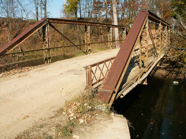
This bridge was an impressive pony truss, with a length over 80 feet, making it among the longest pony truss spans in Michigan. It included a fairly large top chord for a pin-connected truss bridge, due to its decent length, and its built-up beams added complexity and beauty to the bridge including v-lacing under the top chord and on the vertical members. Lattice guardrails remained on this bridge. This bridge was actually open to traffic with a three ton weight limit. It could easily have been rehabilitated to support far more weight. The deck was a rare concrete jack-arch deck, consisting of concrete poured between steel deck stringers with arched corrugated steel spanning between the stringers to act as a base for the concrete to set upon. Faint traces of silvery-grey paint remained on parts of the bridge. Steel on the bridge was from the Cambria Steel mills, as the markings indicated. Eye-bars on the bottom chord were of the loop-forged variety. The bridge was composed of five panels. The structure had experienced some rusting in the bottom connections, and pack rust was pushing up parts of the cover plate for the top chord. These issues could easily have been corrected inexpensively through rehabilitation. This bridge crossed the river in a small river valley but with a reasonably steep drop-off on the north side.
This bridge carried "traffic" on a dead-end road that served a single house. The listed Average Daily Traffic was listed as 15, likely an exaggeration unless the owners of the house drive back and forth a lot. As mentioned before, this bridge could have easily been rehabilitated to have a much higher weight limit than three tons. But how did the St. Joseph County Road Commission decide to spend tax dollars? Instead, this bridge which was listed on the National Register of Historic Places, was demolished and replaced with a two lane bridge. This bridge could have likely been rehabilitated for far less than the cost of replacement. And a two-lane bridge on a dead-end road with an ADT of 15 serving one house is clearly an excessive waste of tax dollars. You can thank flawed federal and state funding programs for encouraging the road commissions to make such wasteful decisions. The road commission likely paid very little for this new bridge, since state and/or federal sources would have forked over the majority of the money. Regardless of the source however, this is your tax dollars. Is it wise to spend so much money to obliterate history when that history could have been preserved while also saving taxpayer money?
Finally, even if the bridge was to be replaced, it is most unfortunately that the road commission did not carefully dismantle this bridge and place it into storage as nearby Indiana does with many historic bridges it replaced. This would have kept the bridge available for reuse. The bridge could have been a great structure to restore and reuse on a non-motorized trail somewhere.
![]()
![]()
![]()
This historic bridge has been demolished. This map is shown for reference purposes only.
Coordinates (Latitude, Longitude):
Search For Additional Bridge Listings:
Bridgehunter.com: View listed bridges within 0.5 miles (0.8 kilometers) of this bridge.
Bridgehunter.com: View listed bridges within 10 miles (16 kilometers) of this bridge.
Additional Maps:
Google Streetview (If Available)
GeoHack (Additional Links and Coordinates)
Apple Maps (Via DuckDuckGo Search)
Apple Maps (Apple devices only)
Android: Open Location In Your Map or GPS App
Flickr Gallery (Find Nearby Photos)
Wikimedia Commons (Find Nearby Photos)
Directions Via Sygic For Android
Directions Via Sygic For iOS and Android Dolphin Browser
USGS National Map (United States Only)
Historical USGS Topo Maps (United States Only)
Historic Aerials (United States Only)
CalTopo Maps (United States Only)

© Copyright 2003-2024, HistoricBridges.org. All Rights Reserved. Disclaimer: HistoricBridges.org is a volunteer group of private citizens. HistoricBridges.org is NOT a government agency, does not represent or work with any governmental agencies, nor is it in any way associated with any government agency or any non-profit organization. While we strive for accuracy in our factual content, HistoricBridges.org offers no guarantee of accuracy. Information is provided "as is" without warranty of any kind, either expressed or implied. Information could include technical inaccuracies or errors of omission. Opinions and commentary are the opinions of the respective HistoricBridges.org member who made them and do not necessarily represent the views of anyone else, including any outside photographers whose images may appear on the page in which the commentary appears. HistoricBridges.org does not bear any responsibility for any consequences resulting from the use of this or any other HistoricBridges.org information. Owners and users of bridges have the responsibility of correctly following all applicable laws, rules, and regulations, regardless of any HistoricBridges.org information.
![]()