

View Information About HSR Ratings
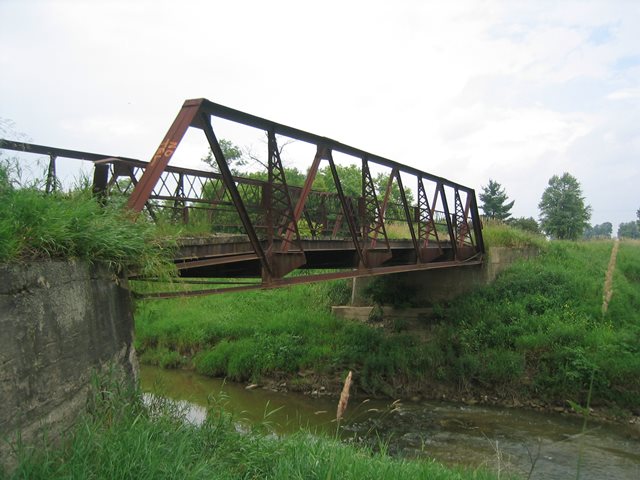
The Cash Road Bridge is a Warren pony truss with riveted connections. Michigan Historic Bridge Inventory says the bridge was built in 1910. It was similar in design to other pony truss bridges that once existed in substantial numbers in this region. Unlike many of those similar bridges that had concrete jack-arch decks, this bridge had a wooden deck. The bridge retains original guardrails, with no modern railings added. The Cash Road Bridge sat on concrete abutments prior to being moved. The bridge had a posted weight limit of ten tons. Like most bridges in the thumb area of Michigan, this bridge had rusted beyond the point of even being able to tell what it might have been painted at one time. No plaques were on the bridge.
This bridge was replaced with a new bridge. This bridge was located in an area where there were several alternative crossings within a mile. People needing to haul more then ten tons somewhere had lots of other options. This bridge could have been repaired to continue serving light-weight traffic. Cash Road did not appear to be a busy road, even by dirt road standards. With so many nearby Elk Creek crossings, it seemed only a waste of money to replace this bridge.
The only good news was that when this bridge was replaced a local landowner took the bridge with plans to eventually use it on his property. So the bridge was not sent to the scrap yard when it was replaced.

Above: Historical photo of bridge.
![]()
![]()
![]()
Coordinates (Latitude, Longitude):
Search For Additional Bridge Listings:
Bridgehunter.com: View listed bridges within 0.5 miles (0.8 kilometers) of this bridge.
Bridgehunter.com: View listed bridges within 10 miles (16 kilometers) of this bridge.
Additional Maps:
Google Streetview (If Available)
GeoHack (Additional Links and Coordinates)
Apple Maps (Via DuckDuckGo Search)
Apple Maps (Apple devices only)
Android: Open Location In Your Map or GPS App
Flickr Gallery (Find Nearby Photos)
Wikimedia Commons (Find Nearby Photos)
Directions Via Sygic For Android
Directions Via Sygic For iOS and Android Dolphin Browser
USGS National Map (United States Only)
Historical USGS Topo Maps (United States Only)
Historic Aerials (United States Only)
CalTopo Maps (United States Only)

© Copyright 2003-2024, HistoricBridges.org. All Rights Reserved. Disclaimer: HistoricBridges.org is a volunteer group of private citizens. HistoricBridges.org is NOT a government agency, does not represent or work with any governmental agencies, nor is it in any way associated with any government agency or any non-profit organization. While we strive for accuracy in our factual content, HistoricBridges.org offers no guarantee of accuracy. Information is provided "as is" without warranty of any kind, either expressed or implied. Information could include technical inaccuracies or errors of omission. Opinions and commentary are the opinions of the respective HistoricBridges.org member who made them and do not necessarily represent the views of anyone else, including any outside photographers whose images may appear on the page in which the commentary appears. HistoricBridges.org does not bear any responsibility for any consequences resulting from the use of this or any other HistoricBridges.org information. Owners and users of bridges have the responsibility of correctly following all applicable laws, rules, and regulations, regardless of any HistoricBridges.org information.
![]()