

View Information About HSR Ratings
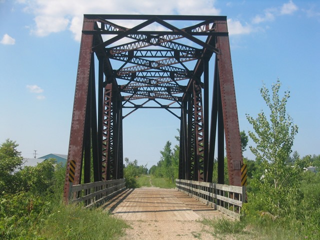
This is a warren through truss with riveted connections. It has v-lacing on a couple diagonals, the bottom chord, and on all struts and lateral bracing above the deck. One cracked plaque survives on the bridge, crediting the American Bridge Company of New York with building the bridge in 1904. The American Bridge company would have only been around for a handful of years, so this is an early example of the conglomerate company's work. The American Bridge Company was formed from a number of smaller bridge companies, including the well known Wrought Iron Bridge Company of Canton, Ohio. The American Bridge Company was a part of US Steel, and went on to build countless other bridges, including the Mackinac Bridge. This railroad bridge now serves as a snowmobile rail-trial. No repairs or repainting of the superstructure was done as part of the conversion. The wooden railings placed on the bridge have a gaudy appearance and detract from the visual qualities of the structure. Metal pole railings might have been a better option here, as they would have blended into the trusses better.
This bridge is tagged with the following special condition(s): Unorganized Photos
![]()
![]()
![]()
![]()
![]()
Coordinates (Latitude, Longitude):
Search For Additional Bridge Listings:
Bridgehunter.com: View listed bridges within 0.5 miles (0.8 kilometers) of this bridge.
Bridgehunter.com: View listed bridges within 10 miles (16 kilometers) of this bridge.
Additional Maps:
Google Streetview (If Available)
GeoHack (Additional Links and Coordinates)
Apple Maps (Via DuckDuckGo Search)
Apple Maps (Apple devices only)
Android: Open Location In Your Map or GPS App
Flickr Gallery (Find Nearby Photos)
Wikimedia Commons (Find Nearby Photos)
Directions Via Sygic For Android
Directions Via Sygic For iOS and Android Dolphin Browser
USGS National Map (United States Only)
Historical USGS Topo Maps (United States Only)
Historic Aerials (United States Only)
CalTopo Maps (United States Only)

© Copyright 2003-2024, HistoricBridges.org. All Rights Reserved. Disclaimer: HistoricBridges.org is a volunteer group of private citizens. HistoricBridges.org is NOT a government agency, does not represent or work with any governmental agencies, nor is it in any way associated with any government agency or any non-profit organization. While we strive for accuracy in our factual content, HistoricBridges.org offers no guarantee of accuracy. Information is provided "as is" without warranty of any kind, either expressed or implied. Information could include technical inaccuracies or errors of omission. Opinions and commentary are the opinions of the respective HistoricBridges.org member who made them and do not necessarily represent the views of anyone else, including any outside photographers whose images may appear on the page in which the commentary appears. HistoricBridges.org does not bear any responsibility for any consequences resulting from the use of this or any other HistoricBridges.org information. Owners and users of bridges have the responsibility of correctly following all applicable laws, rules, and regulations, regardless of any HistoricBridges.org information.
![]()