

View Information About HSR Ratings
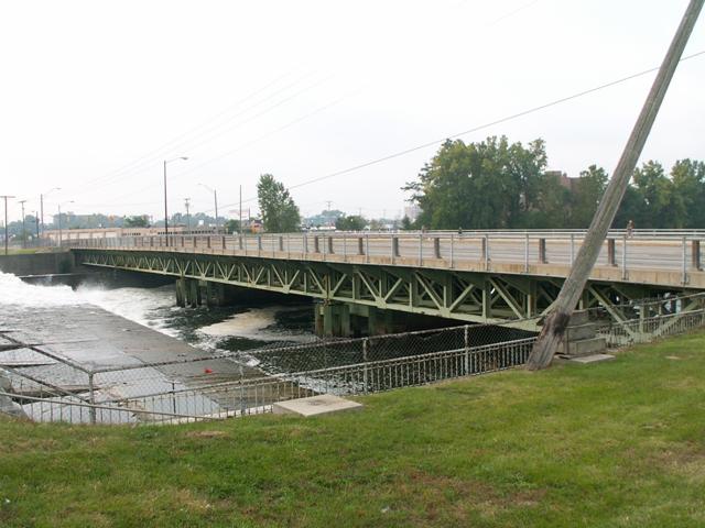
This was not the most impressive deck truss, but it was still very unusual. The bridge was built in 1918, and was widened in the 1950s with additional deck truss lines. In either 1981 or 1994, the bridge was again widened, this time with ugly concrete beams, that severely obstructed the view of the truss. This widening appears to have concealed the original 1918 trusses in the center of the bridge. Obviously, doing this was better than demolishing the entire bridge, for both historic and economical reasons, but it really hurt the look of the bridge. The truss part of this bridge was a three span warren deck truss. Piers on the bridge were steel bents. Photographs were hard to get for this bridge because the truss side was right next to a dam which is all fenced off. Now the bridge is gone forever, replaced by an ugly modern bridge. It appears that the concrete beams that had been added to the historic bridge were reused at this time, because the National Bridge Inventory today claims the bridge standing today was built in 1994 and rebuilt in 2010.
Information and Findings From DHPA Historic Bridge SurveyHistory The spanning of the St. Joseph River in Elkhart at then-named Elkhart Avenue occurred before the Civil War. A three-span wooden structure existed in 1866. In 1867, the Elkhart Hydraulic Company constructed a wooden dam above the bridge to water the canal. In December 1885, the county commissioners received petitions to construct a new bridge over the hydraulic race and to repair the adjacent Elkhart Avenue Bridge. In January, the board decided to replace old race bridge with one of iron. It also agreed to new cut-stone abutments for the race and the river bridges. In March, the Massillon Bridge Company won the contract for the iron superstructure at $1,450, and, in April, William Senich bid successfully to build the race and river stone abutments for $4,650. In August, the board learned that the piers on the river bridge were giving way and ordered their immediate replacement, too. The decision of the Indiana and Michigan Electric Company to erect between 1910 and 1913 a concrete dam for the production of electric power near the old dam site changed the equilibrium in the area. In June 1917, the city of Elkhart petitioned the commissioners for a new bridge across the river, and the board ordered the county surveyor to prepare specifications and estimates. The letting for #206--the number assigned the Elkhart Ave. Bridge--was set for August. The board received proposals from two bidders on a variety of designs. The National Concrete Company proposed to build a concrete arch structure of Luten-design for $49,000, a steel structure of county design for $81,700, and on two different Elkhart Bridge and Iron Company (EB&ICo) plans. The EB&ICo bid on the county plan plus its own two designs at figures above those of National Concrete. Instead of taking the lowest bid offered--National Concrete's Luten-design--the board accepted the concrete company proposal to build the county-plan steel bridge. Apparently surprised by the board's action, National Concrete "failed and refused to execute a contract for the construction of said bridge" in steel. In October, the board turned to its second bidder, EB&ICo. They had made a high bid on the county plan, a design that also ran into difficulty with the Indiana and Michigan Electric Company which was expected to pay for the span over the canal. Their lowest bid was for a "plain beam" structure. But the board preferred the company's "lattice girder plan" proposed at $61,800 for the county's share and at $17,400 for the electric company's part. Architectural Description As originally designed and constructed, the 389-ft., all-riveted, Warren deck-truss structure of four spans was erected with cast-steel rockers or shoes upon cast-iron bed plates upon concrete piers and abutments. The three river spans each extend 100 ft. subdivided into ten panels; the canal span reaches 87 ft. The spans carried three trusses placed about 8-ft. 4-in. apart with struts and lateral braces between them. The top chords and inclined endposts consist of a pair of 12-in. channels, growing heavier toward midspan, riveted together with a cover place above and lacing bars below. The lower chord was made from a pair of angles in the two outer panels and doubled thereafter. The webbing relies on angles with their ends riveted to gussets. Two pairs of laced angles of a single size--3x3.5 in.--provide the verticals. Two pairs of mostly-laced angles, lighter toward midspan, supply the diagonals. EB&ICo substituted stay plates for the lacing in the 4th and 7th panels. Riveted to the tops of the verticals through angles, rolled I floor-beams carried a row of I-beams stringers between each truss' top chord. Brackets extended from each end of every floor beam supported a 5-ft. sidewalk on each side of the 25-ft. concrete roadway. In 1953, the county decided to widen the deck
over the deck trusses. EB&ICo prepared plans for a fourth set of trusses
for each span, new shoes and rockers, new floor-beams and stringers, and
new concrete deck and walks. Haines and Haines, contractors, completed
the widening in 1954 to a 44-ft. roadway with 5-ft. walks. The longest
of a handful of Warren deck-truss structures remaining in Indiana--and
one of two extant representatives of an important Hoosier designer and
metal fabricator--spans this crossing of the St. Joseph River and the
canal in the core of Elkhart's 19th century industry and commerce. The
original members of the unadorned bridge--except for floor-beams, shoes,
and deck--have been incorporated into the widened structure. The Indiana
Historical Society holds the firm's original drawings for this bridge
and for its rehabilitation. Additional Description This 389', all-riveted, four-span Warren deck structure was erected upon a concrete substructure for $61,800 by the home town Elkhart Bridge and Iron Company. The Indiana and Michigan Electric Company which has a hydroelectric dam nearby contributed $18,400 to the project. Haines and Haines, contractors, widened the bridge's concrete deck in 1955 to accommodate a 41'7" roadway and a sidewalk on each side. The spans consist of four trusses of ten panels each. Two pairs of angles laced together provide the verticals and most of the diagonals (although stay plates are substituted for the lacing in the 4th and 7th panels). The top chord and endposts were fabricated from laced channels. Riveted to the verticals above the top chord and extended beyond the trusses, I floor beams support the widened deck. Statement of Significance The longest of four Warren deck structures remaining in Indiana and one of two extant representatives of a prolific home-town builder, this unadorned structure retains its original members except for the floor beams and deck. The Indiana Historical Society holds the firm's original drawings for this structure. Bridge Considered Historic By Survey: Yes |
![]()
![]()
This historic bridge has been demolished. This map is shown for reference purposes only.
Coordinates (Latitude, Longitude):
Search For Additional Bridge Listings:
Bridgehunter.com: View listed bridges within 0.5 miles (0.8 kilometers) of this bridge.
Bridgehunter.com: View listed bridges within 10 miles (16 kilometers) of this bridge.
Additional Maps:
Google Streetview (If Available)
GeoHack (Additional Links and Coordinates)
Apple Maps (Via DuckDuckGo Search)
Apple Maps (Apple devices only)
Android: Open Location In Your Map or GPS App
Flickr Gallery (Find Nearby Photos)
Wikimedia Commons (Find Nearby Photos)
Directions Via Sygic For Android
Directions Via Sygic For iOS and Android Dolphin Browser
USGS National Map (United States Only)
Historical USGS Topo Maps (United States Only)
Historic Aerials (United States Only)
CalTopo Maps (United States Only)

© Copyright 2003-2024, HistoricBridges.org. All Rights Reserved. Disclaimer: HistoricBridges.org is a volunteer group of private citizens. HistoricBridges.org is NOT a government agency, does not represent or work with any governmental agencies, nor is it in any way associated with any government agency or any non-profit organization. While we strive for accuracy in our factual content, HistoricBridges.org offers no guarantee of accuracy. Information is provided "as is" without warranty of any kind, either expressed or implied. Information could include technical inaccuracies or errors of omission. Opinions and commentary are the opinions of the respective HistoricBridges.org member who made them and do not necessarily represent the views of anyone else, including any outside photographers whose images may appear on the page in which the commentary appears. HistoricBridges.org does not bear any responsibility for any consequences resulting from the use of this or any other HistoricBridges.org information. Owners and users of bridges have the responsibility of correctly following all applicable laws, rules, and regulations, regardless of any HistoricBridges.org information.
![]()