

View Information About HSR Ratings
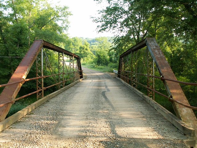
This is a beautiful little bridge tucked back on a rural road. It retains pipe railing, which may not be as visually attractive as lattice railings, but seem to be less common. Many bridges that once had pole railings may have had them removed. In some cases, the pipe uses as bridge railing was "gas pipe" that the bridge builder ordered and adapted for use a a bridge railing.
This bridge is important because it retains its historic integrity and is a good example of a pony truss built by the Penn Bridge Company, which operated out of a very small shop in Beaver Falls, Pennsylvania yet managed to build a surprising number of bridges in the region. A builder plaque is on the bridge, but is attached strangely since it is wider than the end post it is mounted and and as such extends beyond the end post on one side. Perhaps it was the only size plaque the Penn Bridge Company had on hand when the bridge was built, but it is unusual.
Information and Findings From Pennsylvania's Historic Bridge InventoryDiscussion of Bridge The 1890, pin connected, single span, 74'-long, Pratt pony truss bridge is supported on ashlar abutments with wingwalls. It is traditionally composed with built up upper chords, eye bar diagonals and lower chords, and back-to-back angles with laced web verticals. The bridge, one of three in the county fabricated by the Penn Bridge Company or its predecessor, stands out as an early, complete, and documented example of its type and design. It is historically and technologically significant. Discussion of Surrounding Area The bridge carries 1 lane of a 2 lane road over a stream in an agricultural area that lacks the cohesiveness of a potential historic district. Bridge Considered Historic By Survey: Yes |
![]()
![]()
![]()
Coordinates (Latitude, Longitude):
Search For Additional Bridge Listings:
Bridgehunter.com: View listed bridges within 0.5 miles (0.8 kilometers) of this bridge.
Bridgehunter.com: View listed bridges within 10 miles (16 kilometers) of this bridge.
Additional Maps:
Google Streetview (If Available)
GeoHack (Additional Links and Coordinates)
Apple Maps (Via DuckDuckGo Search)
Apple Maps (Apple devices only)
Android: Open Location In Your Map or GPS App
Flickr Gallery (Find Nearby Photos)
Wikimedia Commons (Find Nearby Photos)
Directions Via Sygic For Android
Directions Via Sygic For iOS and Android Dolphin Browser
USGS National Map (United States Only)
Historical USGS Topo Maps (United States Only)
Historic Aerials (United States Only)
CalTopo Maps (United States Only)

© Copyright 2003-2024, HistoricBridges.org. All Rights Reserved. Disclaimer: HistoricBridges.org is a volunteer group of private citizens. HistoricBridges.org is NOT a government agency, does not represent or work with any governmental agencies, nor is it in any way associated with any government agency or any non-profit organization. While we strive for accuracy in our factual content, HistoricBridges.org offers no guarantee of accuracy. Information is provided "as is" without warranty of any kind, either expressed or implied. Information could include technical inaccuracies or errors of omission. Opinions and commentary are the opinions of the respective HistoricBridges.org member who made them and do not necessarily represent the views of anyone else, including any outside photographers whose images may appear on the page in which the commentary appears. HistoricBridges.org does not bear any responsibility for any consequences resulting from the use of this or any other HistoricBridges.org information. Owners and users of bridges have the responsibility of correctly following all applicable laws, rules, and regulations, regardless of any HistoricBridges.org information.
![]()