

View Information About HSR Ratings
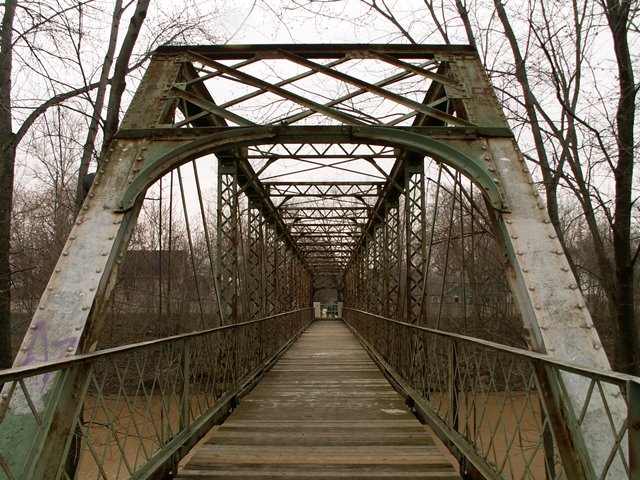
Tucked away in a residential neighborhood, is a bridge that is very unusual, and as a result has a huge amount of historic significance. What makes it significant is a combination of its function and span length. This is a turn-of-the-century pin connected Pratt through truss bridge that was built to support pedestrian traffic only. Often here in the 21st century, historic vehicular truss bridges are restored to support only pedestrian traffic, but here is a bridge that was originally built for pedestrians. Pedestrian foot bridges usually are distinguished by very lightweight members, and most surviving examples display riveted connections rather than pinned connections. In contrast, this pin-connected truss bridge has surprisingly massive members for a foot bridge. This is because the bridge has a substantial span length. At the same time, designed to support only pedestrians, the bridge is both narrow, and has very little vertical clearance, so little in fact that most people could reach up and touch the portal bracing. Additionally, the floor beams, only having to hold pedestrians, are very small! The smaller width and height dimensions of the bridge give the illusion that the bridge is extremely long. This is on top of the fact that this is a fairly long span bridge.
This bridge is an unusual and significant foot bridge. It was built by the prolific and significant King Bridge Company. It retains outstanding historic integrity including original lattice railings. This bridge should receive a very high preservation priority. Some section loss was noted in the bottom chord connections. This is a bridge that would benefit from a comprehensive rehabilitation.
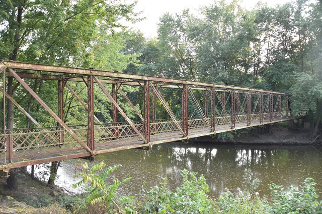
The approach spans on this bridge are supported on what appear to be simple concrete piers. However closer inspection showed an eyebar sticking out of the concrete. It is possible the substructure was originally composed of steel bents that were later encased in concrete.

Information and Findings From DHPA Historic Bridge SurveyArchitectural Description The King Bridge Company of Cleveland secured a $2,100 contract to build this major pedestrian entrance into Swinney Park in 1898. It consists of a through-truss span with five metal beam approaches to the west. The through-truss span consists of 12-foot panels. The top chord and end-posts were fabricated from pair of channels and cover plate riveted together. For the outer pair of panels on each end of the lower chord, the members consist of a pair of channels riveted together with battens; the interior members rely on a pair of eye-bars. A pair of square rods provide the hip verticals; the interior ones were made from a pair of laced 5-inch channels. The diagonals rely on a pair of rectangular eyebars, lighter toward midspan. Five of the more central panels are countered with adjustable square rods. The portal struts are latticed; interior ones are a pair of laced angles and carry knee-braces. Rolled I floor-beams are U-bolted to the pins. They carry runs of channel stringers which support the walkway. Concrete substructure. Timber deck. References Angela M. Quinn of ARCH to James L. Cooper, 22 February 1999, 3 April 2002. Other Information Not Currently Available. Bridge Considered Historic By Survey: Yes |
![]()
![]()
![]()
![]()
![]()
Coordinates (Latitude, Longitude):
Search For Additional Bridge Listings:
Bridgehunter.com: View listed bridges within 0.5 miles (0.8 kilometers) of this bridge.
Bridgehunter.com: View listed bridges within 10 miles (16 kilometers) of this bridge.
Additional Maps:
Google Streetview (If Available)
GeoHack (Additional Links and Coordinates)
Apple Maps (Via DuckDuckGo Search)
Apple Maps (Apple devices only)
Android: Open Location In Your Map or GPS App
Flickr Gallery (Find Nearby Photos)
Wikimedia Commons (Find Nearby Photos)
Directions Via Sygic For Android
Directions Via Sygic For iOS and Android Dolphin Browser
USGS National Map (United States Only)
Historical USGS Topo Maps (United States Only)
Historic Aerials (United States Only)
CalTopo Maps (United States Only)

© Copyright 2003-2024, HistoricBridges.org. All Rights Reserved. Disclaimer: HistoricBridges.org is a volunteer group of private citizens. HistoricBridges.org is NOT a government agency, does not represent or work with any governmental agencies, nor is it in any way associated with any government agency or any non-profit organization. While we strive for accuracy in our factual content, HistoricBridges.org offers no guarantee of accuracy. Information is provided "as is" without warranty of any kind, either expressed or implied. Information could include technical inaccuracies or errors of omission. Opinions and commentary are the opinions of the respective HistoricBridges.org member who made them and do not necessarily represent the views of anyone else, including any outside photographers whose images may appear on the page in which the commentary appears. HistoricBridges.org does not bear any responsibility for any consequences resulting from the use of this or any other HistoricBridges.org information. Owners and users of bridges have the responsibility of correctly following all applicable laws, rules, and regulations, regardless of any HistoricBridges.org information.
![]()