

View Information About HSR Ratings
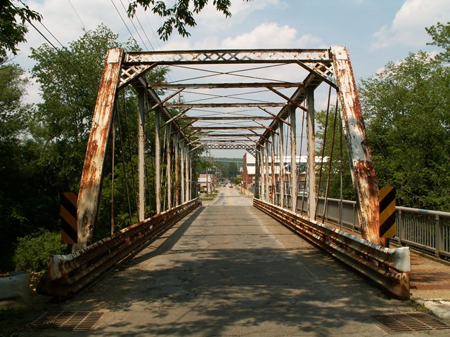
This is a nice classic pin connected Pratt through truss. Judging by the original ornate cast iron end posts that remain at the ends of the single cantilevered sidewalk, it once had ornate railings, but these have been replaced with modern railing. It does retain very tiny lattice hub-guard railing, which hide behind modern Armco guardrail. This bridge features road-ward orientation of its vertical member v-lacing which is less common. The bridge is an attractive structure on a residential street. Although the bridge had substantial deterioration, it would have been a great candidate for rehabilitation for continued light vehicular use. However, the bridge is slated for demolition and replacement.
A 2016 Titusville Herald newspaper article provided long-missing history of this bridge. It noted in 1881 it was built by Morse Bridge Company for $4000, but not opening until June 1, 1882. It noted in June 5, 1892 that a fire in the creek caused the span to collapse, but that it was repaired and re-erected in place.
Information and Findings From Pennsylvania's Historic Bridge InventoryDiscussion of Bridge The ca. 1885, pin connected, single span, 130'-long, Pratt thru truss bridge has several early and non-standard details. The floor beams are above the lower chords. The pins frame into the box-shaped verticals. There are minor welded and bolted repairs, the but the bridge is historically and technologically significant reflecting early thinking about design and connection details. Discussion of Surrounding Area The bridge carries a two-lane street and a sidewalk over Oil Creek in a residential area with late-19th through mid-20th century houses in the city of Titusville. The bridge is at a T intersection with SR 8. Bridge Considered Historic By Survey: Yes |
![]()
![]()
![]()
Coordinates (Latitude, Longitude):
Search For Additional Bridge Listings:
Bridgehunter.com: View listed bridges within 0.5 miles (0.8 kilometers) of this bridge.
Bridgehunter.com: View listed bridges within 10 miles (16 kilometers) of this bridge.
Additional Maps:
Google Streetview (If Available)
GeoHack (Additional Links and Coordinates)
Apple Maps (Via DuckDuckGo Search)
Apple Maps (Apple devices only)
Android: Open Location In Your Map or GPS App
Flickr Gallery (Find Nearby Photos)
Wikimedia Commons (Find Nearby Photos)
Directions Via Sygic For Android
Directions Via Sygic For iOS and Android Dolphin Browser
USGS National Map (United States Only)
Historical USGS Topo Maps (United States Only)
Historic Aerials (United States Only)
CalTopo Maps (United States Only)

© Copyright 2003-2024, HistoricBridges.org. All Rights Reserved. Disclaimer: HistoricBridges.org is a volunteer group of private citizens. HistoricBridges.org is NOT a government agency, does not represent or work with any governmental agencies, nor is it in any way associated with any government agency or any non-profit organization. While we strive for accuracy in our factual content, HistoricBridges.org offers no guarantee of accuracy. Information is provided "as is" without warranty of any kind, either expressed or implied. Information could include technical inaccuracies or errors of omission. Opinions and commentary are the opinions of the respective HistoricBridges.org member who made them and do not necessarily represent the views of anyone else, including any outside photographers whose images may appear on the page in which the commentary appears. HistoricBridges.org does not bear any responsibility for any consequences resulting from the use of this or any other HistoricBridges.org information. Owners and users of bridges have the responsibility of correctly following all applicable laws, rules, and regulations, regardless of any HistoricBridges.org information.
![]()