

View Information About HSR Ratings
A historical narrative by Diane Fuller, 2009
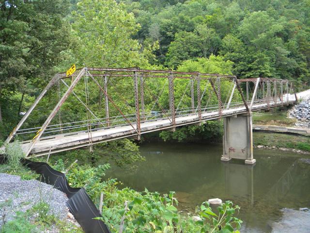
The Blackford Bridge was built in 1889 over the Clinch River,
erected by the Russell County Board of Supervisors. The board of Supervisors
chose a metal Pratt Truss, a growing trend among county officials. Designed for
crossing of rivers and streams, the fabrication was by the Groton Bridge and
Manufacturing Company, a distinctive bridge construction and design of the final
quarter of the nineteenth century. This bridge is one of the oldest remaining
metal truss bridges in the Bristol Construction District. The bridges were sold
by mail order catalog. Prior to the bridge being built David Black ran a ferry
across the river. The bridge was a gateway for farming in the Elk Garden area
and other parts of the county. The bridge linked much needed railroad access.
Farmers had to drive their livestock to the Blackford Depot to be shipped to
various parts of the country and even to England. Farmers had a choice of
driving their livestock through the river or over the bridge. The farmers in the
area also raised corn, wheat, oats, rye, and tobacco which were also shipped out
from the Blackford Depot.
The bridge played an important part in the development of industries into the
area by connecting both sides of the Clinch River. Wagons and later Model T
Fords could drive across the bridge. The coal and timber companies used trucks
to haul freight and supplies. The bridge also played an important part in
helping the Clinch Valley Barite Company. Honaker had the biggest cattle
shipping and lumber yard east of the Mississippi. The Blackford Bridge gave the
people of the surrounding areas including Tazewell and Buchanan Counties, easier
access to the Lebanon area and other parts of the state.
Henry C. Stuart played a major role in getting the bridge in Blackford. When the
bridge was built two bridge plates were installed (one) on each end of the
bridge. One side of the plate had H. C. Stuart and H. H. Dickenson -
Commissioner. The reversed side of the plates had the Groton Bridge Company's
name and the date the bridge was constructed 1889. In 1921 Henry Stuart helped
organize and served as president of the pay as-you-go roads association. He also
served as Chairman of Virginia's First State Corporation Commission. He was
Governor of Virginia from 1914-1918 during World War II. Henry's Father founded
Stuart Land and Cattle Company, which has been in operation for over 235 years
(and greatly depended on the Blackford Bridge for shipping of their livestock).
He moved to Saltville in 1861 to operate Preston Salt works and supplied salt
for the Confederate Army. Gov. Stuart's Uncle Major General J. E. B. Stuart also
played and important role in the Civil War. Stuart Land and Cattle supplied
beef, and also broke and trained horses for the Confederate Army. Gov. Stuart
became owner and operator of Stuart Land and Cattle Co. in 1893. It was the
oldest business still in operation today in Russell County and also the oldest
cattle ranch in the U. S. continually managed by the same family.
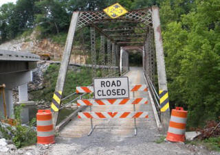
Puckett's Hole residents had no bridge until The Blackford Bridge was moved to
the Chestnut Ridge area in 1946. Residents had to use boats to cross the river
until the bridge was in place. The bridge was taken down piece by piece and
transported by ferry to its new location. It was then put into place where it is
still in use today. A new bridge has recently been constructed and the old
bridge is standing proud. It has played a major role in the completion of the
new bridge. Heavy equipment and supplies have been taken across the old bridge
to complete the new one.
Over the years it has served the public as a Historic Monument, and a local
tourist attraction in Russell County. It has served motorist, bikers, hikers and
the Honaker Redbud Festival's canoe race. It should be left for all of these
purposes and to teach the younger generations of Russell County about some of
the heritage of their ancestors. If we do not preserve our heritage it will be
lost and forgotten in time.
By: Diane Fuller
This bridge has two 113 foot spans totaling 225 feet. The bridge has 12.5 Feet (3.8 Meters) of vertical clearance. This bridge is a beautiful example of one of the standard designs created and marketed by the noteworthy bridge company, Groton Bridge Company. Distinctive characteristics of the design include the heavy verticals with lattice on both sides of the back-to-back channels, pedimented away bracing, and arch-shaped plaques, which were in storage at the time this bridge was photo-documented. Despite being relocated in 1946, the truss superstructure of the bridge, which is where the bridge's historic significance is drawn from, retains a high degree of historic integrity with the most noteworthy alteration being the alteration in some parts of the hip verticals. All other areas of the bridge appear largely unaltered. The bridge is a regionally important bridge. States south and east Virginia are have a striking lack of pin-connected truss bridges, and the bridge is also one of the only pre-1900 truss bridges in the entire southwestern finger of Virginia. As a two-span structure, it is a long, distinguished example of a once-common bridge type that is today rare. It is also a good, multi-span example of one of the Groton Bridge Company bridge designs. The Fleegle Bridge is a single-span example in Pennsylvania that exhibits the same style/design. Note that the Fleegle Bridge has decorative finials on the top of the endposts, a feature that some other Groton Bridge Company bridges of this design also exhibit. It is unclear if the Blackford Bridge might have once had these finials... the finials are notorious for either falling off or being taken, as seen in the Fleegle Bridge, which has some missing. The state of Michigan is home to perhaps the most complete and well-preserved example (Portland Bridge) of this Groton design and it also serves as an example of the potential a restored Blackford Bridge might have.
Pratt Truss Bridges in Virginia: Are They Really Common?
This bridge was in the past evaluated as non-hisstoric partially because it was considered by the evaluators to be common. This assessment of the bridge as non-historic is so absurd that it is hard to believe that anyone even bought it. They claimed this because ten years ago, there were 44 other "Pratt through truss bridges" in the state, and as such the bridge is a common structure type. Is that a lot? If all 44 were multi-span pre-1890 truss bridges and all were still here in 2009, it does indeed seem like a lot, right? Take a look at the facts and decide for yourself. According to publically available National Bridge Inventory data, in 2008 there were 13,488 bridges in the Commonwealth of Virginia. Therefore, Pratt through truss bridges compose 0.32% of all bridges in the state. Now granted, the word "common" is a relative term, but most people are not going to consider anything under 1% to be common. It gets even worse when you consider how low the density of truss bridges in the state is. Virginia has a land area of 39,594 square miles. Doing some simple division, it turns out there is one Pratt through truss bridge in Virginia per 900 square miles.
Virginia's Truss Bridge Density Compared To Other States
How does Virginia's truss bridge density measure up with other states? For this portion of the study, Historicbridges.org looked at truss bridges of any type and date, because this data is more readily available for each state, and then compared the density of truss bridges in Virginia to several states with which Historicbridges.org was familiar with, were east of the Mississippi River, and have an above average number of historic truss bridge preservation programs. Choosing states with above average bridge preservation programs was important for this because these should be states where truss bridges are either low in number and thus considered rare or were frequently evaluated as historic even if there were a lot of truss bridges in the state. The results of some extremely simple research and math follow. In Virginia, there are 152 truss bridges, which is one truss bridge for each 260 square mile unit of land area. In Indiana, there are 469 truss bridges, and the state has a land area 35867 square miles, which yields one truss bridge for each 76 square mile unit of land area, well over three times the truss density of Virginia. Further, consider that the reason truss bridges are preserved so often in Indiana is that so many truss bridges were demolished in years past that people realized truss bridges were becoming rare in the state and so preservation projects started popping up. In Indiana, a truss density three times higher than that of Virginia reaps an assessment of truss bridges as rare and worthy of preservation. New York has similar statistics as Indiana, as another state with a excellent preservation program, including one that has preserved dozens of truss bridges on the Erie Canal, which are by the way still considered historic even though there are dozens of nearly identical bridges on the canal. New York has one truss bridge for each 82 square mile unit of land area. Maryland, home of Frederick County which rehabilitated all its metal truss bridges which are considered historic, has one truss bridge for each 113 square mile unit of land area. New Jersey has one truss bridge for each 41 square mile unit of land area, which is a whopping six times the truss density of Virginia. New Jersey appears to have a good truss bridge maintenance and preservation attitude. As a final example, Massachusetts has one truss bridge for each 86 square mile unit of land area, and they preserve many of their truss bridges.
Bridge Relocation And National Register Eligibility
The Blackford Bridge was initially considered ineligible for the National Register because it was moved. For most historic buildings and structures, if the structure has been moved it loses historic significance and may even become ineligible for the National Register. However, most people involved with the National Register have come to the consensus that with metal truss bridges, the relocation of a bridge should not result in its being determined ineligible, as long as the superstructure retains historic integrity. Yes, moving a truss bridge reduces its connection to community and our understanding of the bridge and surrounding area's purpose and needs over the course of history. And yes, certainly in preservation planning, leaving a historic truss bridge in its original location where it can maintain its ties to its community and any connected history, is preferred. However despite this, the design of truss bridges, especially pin-connected bridges like the Blackford Bridtge as a "kit bridge" meant that they were easily moved, even back in the turn of the 20th Century when these bridges were the standard bridge type. Metal truss bridges have a rich history in being relocated by virtue of their bridge type. The fact that they were able to be so easily moved is indeed part of the historic significance... the historic identity... of the metal truss bridge. It also is connected to the thinking of the time when the bridge was relocated. When this bridge was relocated in 1946 it was a time where perhaps building a new steel bridge was more costly or wasteful (aside from the fact World War II which caused a steel shortage was just over). The fact that a bridge was relocated and reused in 1946 suggests the different sort of thinking than is seen today where bridges are rarely maintained and repaired, let alone relocated or reused except as historic preservation projects like that which hopefully will be executed with this bridge. Therefore, whether the bridge was moved in 1918 or in 2009, relocation generally does not retract a truss from National Register eligibility.
Historic Blackford Bridge: Worthy of Preservation
As this lengthy narrative has attempted to show, the Blackford Bridge is an important historic bridge in a state that is anything but truss-rich. Truss bridges are not common in Virginia, and among them, the Blackford Bridge is a long, impressive, important, and historically intact example, that is worthy of preservation.
![]()
![]()
Coordinates (Latitude, Longitude):
Search For Additional Bridge Listings:
Bridgehunter.com: View listed bridges within 0.5 miles (0.8 kilometers) of this bridge.
Bridgehunter.com: View listed bridges within 10 miles (16 kilometers) of this bridge.
Additional Maps:
Google Streetview (If Available)
GeoHack (Additional Links and Coordinates)
Apple Maps (Via DuckDuckGo Search)
Apple Maps (Apple devices only)
Android: Open Location In Your Map or GPS App
Flickr Gallery (Find Nearby Photos)
Wikimedia Commons (Find Nearby Photos)
Directions Via Sygic For Android
Directions Via Sygic For iOS and Android Dolphin Browser
USGS National Map (United States Only)
Historical USGS Topo Maps (United States Only)
Historic Aerials (United States Only)
CalTopo Maps (United States Only)

© Copyright 2003-2024, HistoricBridges.org. All Rights Reserved. Disclaimer: HistoricBridges.org is a volunteer group of private citizens. HistoricBridges.org is NOT a government agency, does not represent or work with any governmental agencies, nor is it in any way associated with any government agency or any non-profit organization. While we strive for accuracy in our factual content, HistoricBridges.org offers no guarantee of accuracy. Information is provided "as is" without warranty of any kind, either expressed or implied. Information could include technical inaccuracies or errors of omission. Opinions and commentary are the opinions of the respective HistoricBridges.org member who made them and do not necessarily represent the views of anyone else, including any outside photographers whose images may appear on the page in which the commentary appears. HistoricBridges.org does not bear any responsibility for any consequences resulting from the use of this or any other HistoricBridges.org information. Owners and users of bridges have the responsibility of correctly following all applicable laws, rules, and regulations, regardless of any HistoricBridges.org information.
![]()