

View Information About HSR Ratings
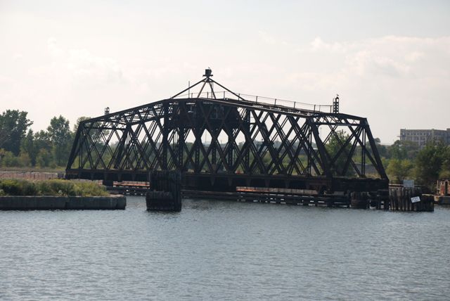
Thhis bridge was originally built 200 feet upriver ca. 1880. It was relocated here 1898 and widened. As such, the bridge is altered, but the portions that date to 1880 would be among the oldest surviving railroad swing trusses in the country. Further, 1898 alterations themselves are historic, thus the bridge remains highly significant as an important historic bridge.
Lattice trusses (sometimes called Warren Quadrangular trusses) range from uncommon to rare on a national scale, but are much more common locally in Wisconsin and particularly the Milwaukee, relatively speaking. This example is further rare on a national scale as a movable lattice truss. This is a large example, and the shape of the swing bridge follows a continuous Camelback style.
This bridge is still in use, and is difficult to access as a result. While this bridge is worthy of the full set of structural detail photos that HistoricBridges.org normally provides, due to these circumstances currently only a couple overview shots of this important bridge are available.

Above: Aerial view of bridge, August 20, 2020. Click for enlargement. Photo Credit: Doug Heim, Angelcopter, LLC
![]()
![]()
![]()

![]()
Coordinates (Latitude, Longitude):
Search For Additional Bridge Listings:
Bridgehunter.com: View listed bridges within 0.5 miles (0.8 kilometers) of this bridge.
Bridgehunter.com: View listed bridges within 10 miles (16 kilometers) of this bridge.
Additional Maps:
Google Streetview (If Available)
GeoHack (Additional Links and Coordinates)
Apple Maps (Via DuckDuckGo Search)
Apple Maps (Apple devices only)
Android: Open Location In Your Map or GPS App
Flickr Gallery (Find Nearby Photos)
Wikimedia Commons (Find Nearby Photos)
Directions Via Sygic For Android
Directions Via Sygic For iOS and Android Dolphin Browser
USGS National Map (United States Only)
Historical USGS Topo Maps (United States Only)
Historic Aerials (United States Only)
CalTopo Maps (United States Only)

© Copyright 2003-2024, HistoricBridges.org. All Rights Reserved. Disclaimer: HistoricBridges.org is a volunteer group of private citizens. HistoricBridges.org is NOT a government agency, does not represent or work with any governmental agencies, nor is it in any way associated with any government agency or any non-profit organization. While we strive for accuracy in our factual content, HistoricBridges.org offers no guarantee of accuracy. Information is provided "as is" without warranty of any kind, either expressed or implied. Information could include technical inaccuracies or errors of omission. Opinions and commentary are the opinions of the respective HistoricBridges.org member who made them and do not necessarily represent the views of anyone else, including any outside photographers whose images may appear on the page in which the commentary appears. HistoricBridges.org does not bear any responsibility for any consequences resulting from the use of this or any other HistoricBridges.org information. Owners and users of bridges have the responsibility of correctly following all applicable laws, rules, and regulations, regardless of any HistoricBridges.org information.
![]()