

View Information About HSR Ratings

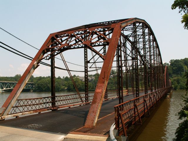
This bridge is a four span structure. The two largest spans are located on the western end of the bridge, and those featured pinned connections. The other two spans are smaller, feature riveted connections, and are located on the east end of the bridge. The 1922 date seems late for a bridge with pin-connected spans and featuring members that are not overly massive, and a deck that is under 20 feet wide. Regardless of whether the bridge is 1922 or is older, the fact remains that it is a very large, multi-span example of a truss bridge featuring spans that include pinned connections, and those spans are of significant length. The bridge features relatively good historic integrity, especially for West Virginia, where many surviving truss bridges display numerous alterations. The bridge even retains original railings. As a result, this is a bridge that is historically significant. In addition, it is located in a scenic lake (which is a reservoir on Cheat River) that appears to be favored for recreational use.
Despite the beauty and history of the bridge, this historic structure is being replaced and demolished. Given the length and significance of the bridge, the demolition of this bridge will be a serious loss to West Virginia's transportation heritage. It is unclear why none of the wide variety of possible alternatives to demolition were not determined to be possible at this location. Most likely it is simply because someone is not interested in taking the time to work out a preservation plan. This nation is severely lacking in its efforts and resolve to preserve historic bridges of any type save the over-rated covered bridges. Even worse is the fate of large historic bridges. Granted, preservation of larger bridges may cost more, but one must take into account the greater historic significance of larger bridges, and also the fact that large bridges tend to attract more attention and offer a larger impact on the appearance of a landscape. As such, it seems worthwhile to go the extra mile to preserve these larger bridges. Apparently, West Virginia officials do not agree with this assessment.
The bridge is in a position where alignment involves a nearly 90 degree turn to get on the bridge. As such, there does not appear to be any sacrifice to alignment quality if a new bridge is built on a new alignment next to the historic bridge, allowing the historic bridge to remain standing for its historic value. The bridge could be restored for pedestrian use. The recreational value of the area suggests that the restored bridge would be a useful and attractive part of the area.
The two larger spans are most significant because they are larger, and also because they are pin-connected. At rock bottom, the least that should be done is to relocate and preserve these two spans elsewhere.
![]()

![]()
![]()
![]()
![]()
This historic bridge has been demolished. This map is shown for reference purposes only.
Coordinates (Latitude, Longitude):
Search For Additional Bridge Listings:
Bridgehunter.com: View listed bridges within 0.5 miles (0.8 kilometers) of this bridge.
Bridgehunter.com: View listed bridges within 10 miles (16 kilometers) of this bridge.
Additional Maps:
Google Streetview (If Available)
GeoHack (Additional Links and Coordinates)
Apple Maps (Via DuckDuckGo Search)
Apple Maps (Apple devices only)
Android: Open Location In Your Map or GPS App
Flickr Gallery (Find Nearby Photos)
Wikimedia Commons (Find Nearby Photos)
Directions Via Sygic For Android
Directions Via Sygic For iOS and Android Dolphin Browser
USGS National Map (United States Only)
Historical USGS Topo Maps (United States Only)
Historic Aerials (United States Only)
CalTopo Maps (United States Only)

© Copyright 2003-2024, HistoricBridges.org. All Rights Reserved. Disclaimer: HistoricBridges.org is a volunteer group of private citizens. HistoricBridges.org is NOT a government agency, does not represent or work with any governmental agencies, nor is it in any way associated with any government agency or any non-profit organization. While we strive for accuracy in our factual content, HistoricBridges.org offers no guarantee of accuracy. Information is provided "as is" without warranty of any kind, either expressed or implied. Information could include technical inaccuracies or errors of omission. Opinions and commentary are the opinions of the respective HistoricBridges.org member who made them and do not necessarily represent the views of anyone else, including any outside photographers whose images may appear on the page in which the commentary appears. HistoricBridges.org does not bear any responsibility for any consequences resulting from the use of this or any other HistoricBridges.org information. Owners and users of bridges have the responsibility of correctly following all applicable laws, rules, and regulations, regardless of any HistoricBridges.org information.
![]()