

View Information About HSR Ratings
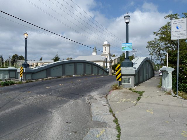
This is an extremely rare bridge that appears to be an example of a concrete curved chord through girder bridge. A number of states built a number of "straight chord" concrete through girders in the first few decades of the 20th Century. However, only a few states ever built these girder bridges with a curved chord design. Only Michigan and Ohio built significant numbers of these bridges types (these states adopted a standard plan for this bridge type), while other states like California only have a couple examples that do not appear to conform to a standard plan. The other two California bridges are quite different in appearance from this bridge.
As a curved chord through girder bridge, this bridge is noteworthy as an extremely early example with its construction date of 1915. This predates examples in most if not all other states, including Michigan which is generally considered to be where the most innovation occurred with this bridge type. The Grove Way Bridge has a span length of 60 feet. 60 feet is about as large as most states ever built concrete girder bridges, except for Michigan which constructed curved chord through girder bridges with up to 90 foot span lengths.
The Grove Way Bridge retains excellent historic integrity with no major alterations.
Information About Thomas B. RussellThomas Bartlett Russell has contributed in various ways to the development of Hayward and Alameda county, where he has important agricultural interests and also has been active in contracting and building for
some time. He was born December 11, 1861, on a tract of the old Soto ranch near Hayward and is a son of Joel Russell, who settled there at an early day in the history of this county and of whom extended mention is made in another
part of this work. Source: Past and Present of Alameda County, California, Volume 2, 1914. |
![]()
![]()
![]()
Coordinates (Latitude, Longitude):
Search For Additional Bridge Listings:
Bridgehunter.com: View listed bridges within 0.5 miles (0.8 kilometers) of this bridge.
Bridgehunter.com: View listed bridges within 10 miles (16 kilometers) of this bridge.
Additional Maps:
Google Streetview (If Available)
GeoHack (Additional Links and Coordinates)
Apple Maps (Via DuckDuckGo Search)
Apple Maps (Apple devices only)
Android: Open Location In Your Map or GPS App
Flickr Gallery (Find Nearby Photos)
Wikimedia Commons (Find Nearby Photos)
Directions Via Sygic For Android
Directions Via Sygic For iOS and Android Dolphin Browser
USGS National Map (United States Only)
Historical USGS Topo Maps (United States Only)
Historic Aerials (United States Only)
CalTopo Maps (United States Only)

© Copyright 2003-2024, HistoricBridges.org. All Rights Reserved. Disclaimer: HistoricBridges.org is a volunteer group of private citizens. HistoricBridges.org is NOT a government agency, does not represent or work with any governmental agencies, nor is it in any way associated with any government agency or any non-profit organization. While we strive for accuracy in our factual content, HistoricBridges.org offers no guarantee of accuracy. Information is provided "as is" without warranty of any kind, either expressed or implied. Information could include technical inaccuracies or errors of omission. Opinions and commentary are the opinions of the respective HistoricBridges.org member who made them and do not necessarily represent the views of anyone else, including any outside photographers whose images may appear on the page in which the commentary appears. HistoricBridges.org does not bear any responsibility for any consequences resulting from the use of this or any other HistoricBridges.org information. Owners and users of bridges have the responsibility of correctly following all applicable laws, rules, and regulations, regardless of any HistoricBridges.org information.
![]()