

View Information About HSR Ratings
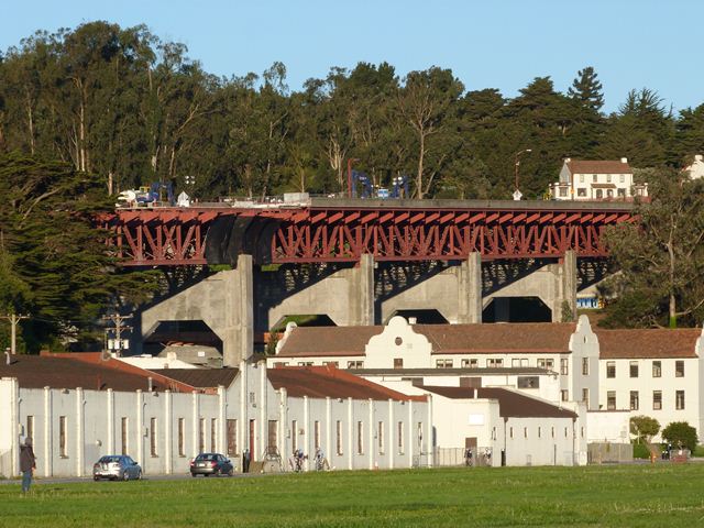
This was a long and impressive viaduct that was highly significant not only for its impressive multi-span deck truss design, but also because it was a part of the approach to the Golden Gate Bridge, the viaduct having been built as part of the same project that constructed the Golden Gate Bridge. Indeed, the viaduct and the contractor who built it is mentioned on the main plaque of the Golden Gate Bridge. The viaduct passed over a setting surrounding by numerous historic buildings. Although not structurally connected to the Golden Gate Bridge, it was part of the approach roadway leading up to the bridge and was designed with art deco details, particularly on the piers, and the deck truss superstructure matched the design of the deck truss approach spans of the Golden Gate Bridge. As such, the bridge was an integral part of the Golden Gate Bridge even if not directly attached to the bridge structure. Despite the fact that the Golden Gate Bridge is one of the most famous and beloved historic bridges in the world, this viaduct portion of the Golden Gate Bridge project has been demolished and replaced with a modern, ugly slab of concrete.
At the time of demolition, the bridge had excellent historic integrity and its trusses, piers, and original paneled concrete railings were all largely unaltered from their original design and materials.
When asked how long the Golden Gate Bridge would last, engineer Joseph Strauss said "Forever!" and "life without end." In contrast, the project website for the demolition of the historic Doyle Drive High Bridge stated that the bridge had reached the end of its useful life. This speaks to two different philosophies, one being that even if "forever" is a stretch, bridges can be maintained and rehabilitated to serve for a very long time, while the other philosophy is that bridges have a short, finite "service life" and so why bother maintaining and rehabilitating bridges? Instead, use them until they wear out and then spend a ton of money demolishing and replacing them. Clearly the latter philosophy was applied to determining the fate of the Doyle Drive Bridge. One can only hope that this philosophy is not extended to the Golden Gate Bridge, built at the same time and with similar construction techniques as the Doyle Drive Bridge. Hopefully the Golden Gate Bridge will not soon be condemned as reaching the end of its useful life alongside a proposal to demolish and replace it with a slab of concrete.
When HistoricBridges.org documented this bridge, demolition had already been started at the eastern end of the viaduct.
![]()
![]()
![]()

![]()
This historic bridge has been demolished. This map is shown for reference purposes only.
Coordinates (Latitude, Longitude):
Search For Additional Bridge Listings:
Bridgehunter.com: View listed bridges within 0.5 miles (0.8 kilometers) of this bridge.
Bridgehunter.com: View listed bridges within 10 miles (16 kilometers) of this bridge.
Additional Maps:
Google Streetview (If Available)
GeoHack (Additional Links and Coordinates)
Apple Maps (Via DuckDuckGo Search)
Apple Maps (Apple devices only)
Android: Open Location In Your Map or GPS App
Flickr Gallery (Find Nearby Photos)
Wikimedia Commons (Find Nearby Photos)
Directions Via Sygic For Android
Directions Via Sygic For iOS and Android Dolphin Browser
USGS National Map (United States Only)
Historical USGS Topo Maps (United States Only)
Historic Aerials (United States Only)
CalTopo Maps (United States Only)

© Copyright 2003-2024, HistoricBridges.org. All Rights Reserved. Disclaimer: HistoricBridges.org is a volunteer group of private citizens. HistoricBridges.org is NOT a government agency, does not represent or work with any governmental agencies, nor is it in any way associated with any government agency or any non-profit organization. While we strive for accuracy in our factual content, HistoricBridges.org offers no guarantee of accuracy. Information is provided "as is" without warranty of any kind, either expressed or implied. Information could include technical inaccuracies or errors of omission. Opinions and commentary are the opinions of the respective HistoricBridges.org member who made them and do not necessarily represent the views of anyone else, including any outside photographers whose images may appear on the page in which the commentary appears. HistoricBridges.org does not bear any responsibility for any consequences resulting from the use of this or any other HistoricBridges.org information. Owners and users of bridges have the responsibility of correctly following all applicable laws, rules, and regulations, regardless of any HistoricBridges.org information.
![]()