

View Information About HSR Ratings

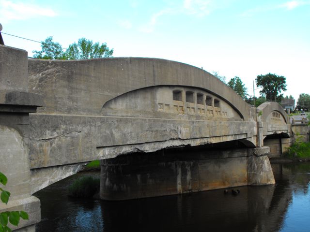
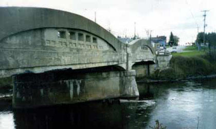
With only slightly more than forty of these bridges remaining as of 1995, according to the decade old historic bridge inventory that made the claim, these strange and beautiful bridges that are unique to Michigan are in short supply. There are far fewer remaining today. Even in shorter supply are multi-span examples, with only two multi-span examples left prior to demolition of this Hillman Bridge, following the destruction of the great Wadhams Road Bridge. Be sure to read the Wadhams Road Bridge page for more details on the historic significance of this unique structure type. This two-span Hillman Bridge, which had a skew, was obviously a rare and important historic transportation resource as a multi-span example, a skewed example, and an old example of its type. This bridge was also one of the few concrete camelback bridges to feature a cantilevered sidewalk. The sidewalk was original to the structure, although the original railings had been replaced. This bridge was built in 1922, and it deserved to stand for centuries to come. However, MDOT did not agree, and they demolished this unique piece of transportation heritage. MDOT's decision to demolish one of the most important historic bridges in the state is a severe stain on the department's previously fairly good record for preserving a number of historic bridges on state trunkline roads. Hopefully, the demolition of this bridge is not a sign of a reduced historic bridge preservation commitment in the years to come.

Above: Demolition. This is how MDOT treated one of the most important historic bridges
in the state.
Photo Credit: Chase Shepherd
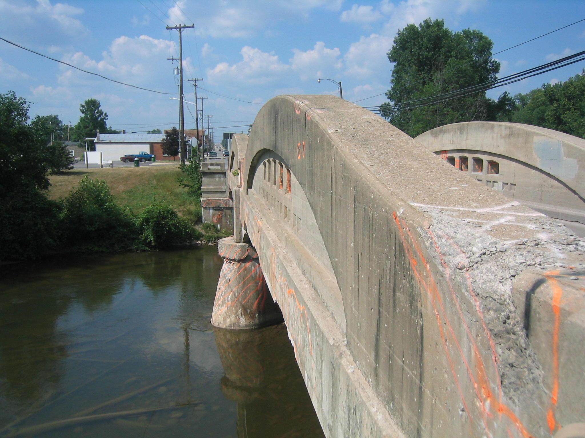
It should also be noted that the only reason this bridge was in poor condition is because it was improperly and incompletely maintained by MDOT. The excessive use of salt and other corrosive deicing chemicals deteriorated the concrete. Not so many years ago, cinders and sand were used on bridges to provide traction while also protecting the bridge from deterioration, but now salt is used everywhere on everything. In addition, MDOT refuses to invest in the research and use of alternative non-corrosive deicing chemicals. In addition, a lack of maintenance and protection of the concrete on the bridge led to its structural deficiency. Maintenance options including patching of concrete and application of a protective concrete paint were never undertaken with this bridge.

MDOT gave many excuses as to why this priceless historic bridge could not be preserved. However these excuses appeared to be obstacles, not barriers to preservation. It is the opinion of Historic Bridges of Michigan and Elsewhere that this bridge could have and should have been preserved, and due to its high level of significance. Certainly, choosing preservation might result in more work as different obstacles are worked through, but the end result would have been worth the effort. The best way to preserve the bridge was to jack the bridge up and slide the historic bridge over and restore it for pedestrian use and construct the new highway bridge in the location that the historic bridge occupied. It is noted that it is indeed possible to slide a big heavy bridge like the Hillman Bridge over using special equipment that jacks the bridge up and slides it over. Perhaps the most ridiculous of obstacles that MDOT has mentioned is that if the bridge were moved over it would be onto a protected historic park that has a historic gristmill on its grounds. However, upon inspection, this mill appears to be largely composed of modern materials and includes other non-historic elements such as large modern picture windows and cyclone fencing. The land around the mill is largely simple grass with a few trees. Given these facts, it seems a poor argument that placing a genuine historic bridge on a portion of the property should be a detriment to the historic integrity of the site. It would seem that because the bridge itself was a nationally significant historic structure, that special privilege should have been granted to use the small part of this land that would have been needed to save this bridge. The bridge, as a historic structure, was in truth an asset to the nearby mill and park and helped create a complete living history scene. Relocating the historic bridge next to the new bridge as a sidewalk would have required very little right-of-way, indeed not much more than the width of the bridge. Further, due to severe alterations, the sidewalk on the historic bridge might as well be removed to reduce the width and land impact of the historic bridge's relocation. Sadly, however MDOT and some of the community seem to have rejected these alternatives to wiping one of the most important historic bridges in Michigan off the face of the earth. Part of the reason the community support for the historic bridge was strangely absent may have been that the local community was brainwashed by MDOT officials into thinking that constructing an ugly new bridge and putting some decorations on it to mimic the historic bridge would be just as nice as preserving the historic bridge. In truth, they will not be. The new bridge will have no historic value whatsoever, and any decorations or aesthetic treatments placed on the new bridge will not accurately replicate the historic bridge.
Each remaining example of Michigan's concrete camelback design is nationally significant. Only isolated examples of this rare bridge type were built outside of Michigan, making each surviving example in Michigan extremely significant and worthy of preservation at any cost. Fortunately, these bridges were structurally overbuilt for the 1920s, and as such, if they are restored can support just about any legal loading. Their detriment of a narrow deck width is easy to deal with by building a new one-lane bridge to form a one-way couplet of bridges. HistoricBridges.org strongly recommends that all surviving concrete camelback bridges in Michigan be re-evaluated as eligible for listing on the National Register of Historic Places. Currently a significant number of surviving examples are listed in the Historic Bridge Inventory as not historic. Given the demolition of a large number of those concrete camelback bridges that were considered eligible for the National Register of Historic Places, it seems nothing short of archaic to consider any the surviving concrete camelbacks as non-historic. Once they are all listed as historic, the next step is to ensure that each surviving concrete camelback bridge has a comprehensive short and long term preservation plan developed to ensure the longevity of the structure.

Information and Findings From Michigan Historic Bridge InventoryNarrative Description
|
![]()
![]()
![]()
![]()
This historic bridge has been demolished. This map is shown for reference purposes only.
Coordinates (Latitude, Longitude):
Search For Additional Bridge Listings:
Bridgehunter.com: View listed bridges within 0.5 miles (0.8 kilometers) of this bridge.
Bridgehunter.com: View listed bridges within 10 miles (16 kilometers) of this bridge.
Additional Maps:
Google Streetview (If Available)
GeoHack (Additional Links and Coordinates)
Apple Maps (Via DuckDuckGo Search)
Apple Maps (Apple devices only)
Android: Open Location In Your Map or GPS App
Flickr Gallery (Find Nearby Photos)
Wikimedia Commons (Find Nearby Photos)
Directions Via Sygic For Android
Directions Via Sygic For iOS and Android Dolphin Browser
USGS National Map (United States Only)
Historical USGS Topo Maps (United States Only)
Historic Aerials (United States Only)
CalTopo Maps (United States Only)

© Copyright 2003-2024, HistoricBridges.org. All Rights Reserved. Disclaimer: HistoricBridges.org is a volunteer group of private citizens. HistoricBridges.org is NOT a government agency, does not represent or work with any governmental agencies, nor is it in any way associated with any government agency or any non-profit organization. While we strive for accuracy in our factual content, HistoricBridges.org offers no guarantee of accuracy. Information is provided "as is" without warranty of any kind, either expressed or implied. Information could include technical inaccuracies or errors of omission. Opinions and commentary are the opinions of the respective HistoricBridges.org member who made them and do not necessarily represent the views of anyone else, including any outside photographers whose images may appear on the page in which the commentary appears. HistoricBridges.org does not bear any responsibility for any consequences resulting from the use of this or any other HistoricBridges.org information. Owners and users of bridges have the responsibility of correctly following all applicable laws, rules, and regulations, regardless of any HistoricBridges.org information.
![]()
 This two-span bridge, with an overall
length of 150 feet, is the fifth longest known surviving example of a
concrete camelback bridge designed by the Michigan State Highway
Department. It consists of two standard 75 foot spans.
This two-span bridge, with an overall
length of 150 feet, is the fifth longest known surviving example of a
concrete camelback bridge designed by the Michigan State Highway
Department. It consists of two standard 75 foot spans.