We Recommend:
Bach Steel - Experts at historic truss bridge restoration.
Eufaula Railroad Bridge

Primary Photographer(s): Dave Michaels
Bridge Documented: February 24, 2010
Railroad (Central of Georgia Railway) Over Chattahoochee River (Walter F George Lake)
Eufaula: Barbour County, Alabama and Quitman County, Georgia: United States
Not Available or Not Applicable
Not Available
Not Available
Not Available
2 Main Span(s) and 2 Approach Span(s)
Not Applicable

View Information About HSR Ratings
Bridge Documentation
This bridge features two main through truss spans that feature partially subdivided Warren truss configuration that has the tendency to trick casual viewers into thinking the bridge is a Baltimore truss. The truss configuration appears to be uncommon nationwide. The truss spans are largely composed of rolled beams, with the top chord and end post being built up (back-to-back channels with cover plate and lattice). The two truss spans are flanked on each side by two deck plate girder approach spans.
This bridge is located in a region where there are literally no historic bridges, or very close to it. Old bridges in the area have either been demolished or never existed. Any that remain have no heritage value. As such, this bridge, which does have heritage value, stands out as a very significant bridge locally.
HistoricBridges.org currently has only a couple photos of this bridge. Feel free to send us any additional full-size digital camera photos you are willing to share.
Russell Wells contacted HistoricBridges.org and provided the following additional information about this and the history of area highway bridges:
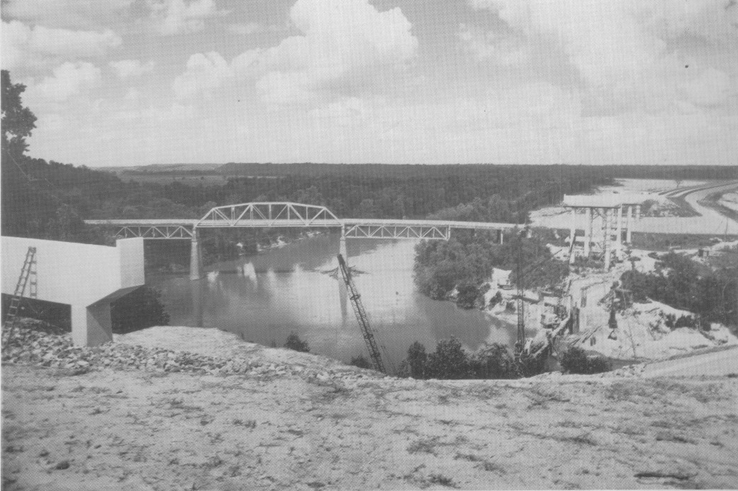
Below is an old photo of the original crossing for US 82 that once ran parallel to this span. It's from about 1961, from when Lake George was being built, and it was just the Chattahoochee River. The photo shows construction of the
four-lane causeway that would be built over the lake, thus necessitating the original truss bridge's removal. In Eufaula, Alabama there is a dead-end street called Beams Drive. This is where US 82 once ran.
You can see that the
railroad bridge itself was originally the Chattahoochee alignment, and they kept the elevated part of the railroad and made it into a causeway without disturbing its path.

![]()
Photo Galleries and Videos: Eufaula Railroad Bridge
Bridge Photo-Documentation
Original / Full Size PhotosA collection of overview and detail photos. This gallery offers photos in the highest available resolution and file size in a touch-friendly popup viewer.
Alternatively, Browse Without Using Viewer
![]()
Bridge Photo-Documentation
Mobile Optimized PhotosA collection of overview and detail photos. This gallery features data-friendly, fast-loading photos in a touch-friendly popup viewer.
Alternatively, Browse Without Using Viewer
![]()
Maps and Links: Eufaula Railroad Bridge
Coordinates (Latitude, Longitude):
Search For Additional Bridge Listings:
Bridgehunter.com: View listed bridges within 0.5 miles (0.8 kilometers) of this bridge.
Bridgehunter.com: View listed bridges within 10 miles (16 kilometers) of this bridge.
Additional Maps:
Google Streetview (If Available)
GeoHack (Additional Links and Coordinates)
Apple Maps (Via DuckDuckGo Search)
Apple Maps (Apple devices only)
Android: Open Location In Your Map or GPS App
Flickr Gallery (Find Nearby Photos)
Wikimedia Commons (Find Nearby Photos)
Directions Via Sygic For Android
Directions Via Sygic For iOS and Android Dolphin Browser
USGS National Map (United States Only)
Historical USGS Topo Maps (United States Only)
Historic Aerials (United States Only)
CalTopo Maps (United States Only)

