

View Information About HSR Ratings
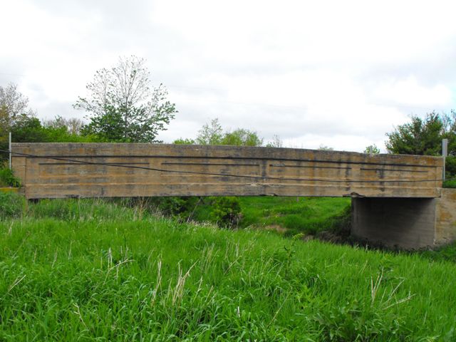
This bridge is an excellent example of a standard plan concrete through girder in Illinois. The bridge is unaltered and retains near-perfect historic integrity, and also remains in good structural condition despite never having been repaired or rehabilitated. This particular example is noteworthy for its span of over 60 feet in length, which is quite long for a concrete through girder. For comparison, in the state of Michigan, where a relatively large number of straight chord through girders survive, the largest known span is 50 feet. In Ohio and Indiana, the few concrete girder spans that reach 60 feet are generally curved chord through girders, not straight chord through girders. It appears that 60 feet is also among the longest spans in Illinois as well. Girders longer than this tended to quickly become inefficient and costly in terms of materials. The long length of this Iroquois County girder was likely made easier by the narrow 18 foot deck. Narrower decks require less massive girders to support the load. This bridge is also significant for its very early 1916 construction date. It was around this time when concrete girders began to be built with frequency. As such, this bridge should be considered historically and technologically significant.
Concrete through girders are a nationally rare structure type today. Their popularity only lasted for about 20 years, mainly between 1915 and 1935, mainly because they were inefficient for deck widths much wider than 22 feet. Michigan and Illinois both appear to have the largest numbers of surviving concrete through girders in the country. This does not mean either state has a large actual number however. As such, surviving examples that have integrity should be considered to have historic value. The bridges tend to be heavily built and very durable. Those examples that are located on quiet rural roads such as this one make good candidates for preservation.
![]()
![]()
![]()
Coordinates (Latitude, Longitude):
Search For Additional Bridge Listings:
Bridgehunter.com: View listed bridges within 0.5 miles (0.8 kilometers) of this bridge.
Bridgehunter.com: View listed bridges within 10 miles (16 kilometers) of this bridge.
Additional Maps:
Google Streetview (If Available)
GeoHack (Additional Links and Coordinates)
Apple Maps (Via DuckDuckGo Search)
Apple Maps (Apple devices only)
Android: Open Location In Your Map or GPS App
Flickr Gallery (Find Nearby Photos)
Wikimedia Commons (Find Nearby Photos)
Directions Via Sygic For Android
Directions Via Sygic For iOS and Android Dolphin Browser
USGS National Map (United States Only)
Historical USGS Topo Maps (United States Only)
Historic Aerials (United States Only)
CalTopo Maps (United States Only)

© Copyright 2003-2024, HistoricBridges.org. All Rights Reserved. Disclaimer: HistoricBridges.org is a volunteer group of private citizens. HistoricBridges.org is NOT a government agency, does not represent or work with any governmental agencies, nor is it in any way associated with any government agency or any non-profit organization. While we strive for accuracy in our factual content, HistoricBridges.org offers no guarantee of accuracy. Information is provided "as is" without warranty of any kind, either expressed or implied. Information could include technical inaccuracies or errors of omission. Opinions and commentary are the opinions of the respective HistoricBridges.org member who made them and do not necessarily represent the views of anyone else, including any outside photographers whose images may appear on the page in which the commentary appears. HistoricBridges.org does not bear any responsibility for any consequences resulting from the use of this or any other HistoricBridges.org information. Owners and users of bridges have the responsibility of correctly following all applicable laws, rules, and regulations, regardless of any HistoricBridges.org information.
![]()