

View Information About HSR Ratings
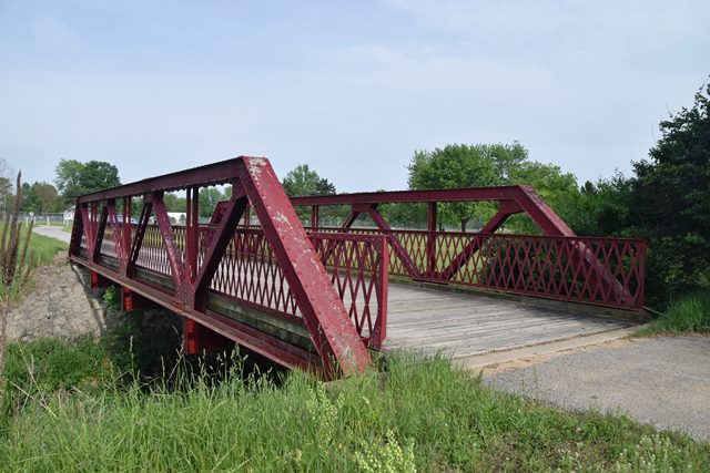
This pony truss bridge built by a notable in-state builder was relocated and preserved for pedestrian use. Lengths given are estimates.
Information and Findings From DHPA Historic Bridge SurveyBridge History and Significance Original Location The Elkhart Bridge & Iron Company fabricated this span and erected it over Peterson Ditch on County Road 600S in 1915. Surveyed Location The county replaced this bridge as a culvert in 1973 and sold the old trusses to Tom Groninger who in turn donated the superstructure to the local trail system for reuse. The structure was rehabilitated and erected over Maish Ditch. Bolted Warren ponies represent an intermediate stage in the truss' development towards all-riveted structures. Except for the metal substructure, this undecorated bridge is of standard design for its type and stage. The structure retains its original members. The Indiana Historical Society holds the plans for this bridge. Listed in the 1990 Bridge Inspection Report as closed and on 1990 and 1992 inspection maps. Not listed in 1996 Inspection Report or on map. Probably replaced with a multiple-plate arch as a culvert. Warren T. Hobson & Associates, Inc. Bridge Inspection Report: Jasper County (Indianapolis, 1974, 1980). Elkhart Bridge & Iron Co. Drawings, D-176, Indiana Historical Society (Indianapolis). Bridge Considered Historic By Survey: Yes |
![]()
![]()
![]()
Coordinates (Latitude, Longitude):
Search For Additional Bridge Listings:
Bridgehunter.com: View listed bridges within 0.5 miles (0.8 kilometers) of this bridge.
Bridgehunter.com: View listed bridges within 10 miles (16 kilometers) of this bridge.
Additional Maps:
Google Streetview (If Available)
GeoHack (Additional Links and Coordinates)
Apple Maps (Via DuckDuckGo Search)
Apple Maps (Apple devices only)
Android: Open Location In Your Map or GPS App
Flickr Gallery (Find Nearby Photos)
Wikimedia Commons (Find Nearby Photos)
Directions Via Sygic For Android
Directions Via Sygic For iOS and Android Dolphin Browser
USGS National Map (United States Only)
Historical USGS Topo Maps (United States Only)
Historic Aerials (United States Only)
CalTopo Maps (United States Only)

© Copyright 2003-2024, HistoricBridges.org. All Rights Reserved. Disclaimer: HistoricBridges.org is a volunteer group of private citizens. HistoricBridges.org is NOT a government agency, does not represent or work with any governmental agencies, nor is it in any way associated with any government agency or any non-profit organization. While we strive for accuracy in our factual content, HistoricBridges.org offers no guarantee of accuracy. Information is provided "as is" without warranty of any kind, either expressed or implied. Information could include technical inaccuracies or errors of omission. Opinions and commentary are the opinions of the respective HistoricBridges.org member who made them and do not necessarily represent the views of anyone else, including any outside photographers whose images may appear on the page in which the commentary appears. HistoricBridges.org does not bear any responsibility for any consequences resulting from the use of this or any other HistoricBridges.org information. Owners and users of bridges have the responsibility of correctly following all applicable laws, rules, and regulations, regardless of any HistoricBridges.org information.
![]()