We Recommend:
Bach Steel - Experts at historic truss bridge restoration.
Jefferson Boulevard Bridge
St. Joseph County Bridge 209

Primary Photographer(s): Nathan Holth
Bridge Documented: October 1, 2006 and April 20, 2014
South Bend: St. Joseph County, Indiana: United States
1905 By Builder/Contractor: Scribner and Heyworth of Chicago, Illinois and Engineer/Design: A. J. Hammond
2004
110.0 Feet (33.5 Meters)
490.0 Feet (149.4 Meters)
51.8 Feet (15.79 Meters)
4 Main Span(s)
7100037

View Information About HSR Ratings
Bridge Documentation
View Archived National Bridge Inventory Report - Has Additional Details and Evaluation
View A Detailed Historical Article About This Bridge
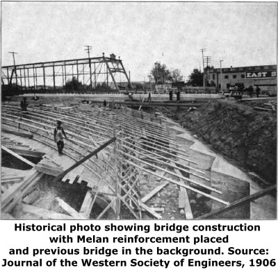
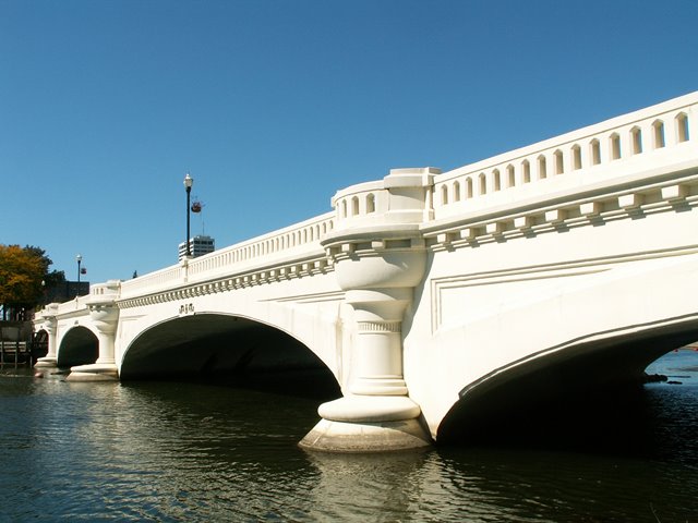
This is one of the oldest and most attractive bridges in the South Bend, Mishawaka, and Elkhart region. It was built in 1905 and is noteworthy for its use of a Melan type of reinforcing which uses solid steel arch ribs inside the concrete instead of rebar. The bridge has substantial architectural embellishment, particularly at the pier points, where cylindrical pillars are present.
This bridge was rehabilitated in 2004. These repairs seem to include re-facing the surface of the arches with modern concrete. The original historic design and architectural elements of the original bridge appear to have been retained however, allowing the bridge to continue to have a good level of historic significance.
Information and Findings From DHPA Historic Bridge SurveyStatement of Significance The bridge is noteworthy on a number of accounts. It is quite old, heavy, long, and skewed. Its Melan system of reinforcing is well-documented and increasingly rare. The replacement deck has reduced without destroying all of the bridge's architectural integrity. Architectural Description Alanzo J. Hammond, South Bend City Engineer,
designed this 490', four-span reinforced and filled concrete arch to
handle a two-track interurban line as well as vehicular and pedestrian
traffic. Scribner and Heyworth of Chicago won the contract to build the
bridge for $119,000 and $6,600 for $20,000 feet of piling. The Wisconsin
Bridge and Iron Company of Milwaukee fabricated the Melan system of
reinforcing. Hammond had the steel trusses from the old bridge moved to
Spring Brook park for $7,000. Bridge Considered Historic By Survey: Yes, Outstanding |
This bridge is tagged with the following special condition(s): Unorganized Photos
![]()
Photo Galleries and Videos: Jefferson Boulevard Bridge
2006 Bridge Photo-Documentation
Original / Full Size PhotosA collection of overview and detail photos. This gallery offers photos in the highest available resolution and file size in a touch-friendly popup viewer.
Alternatively, Browse Without Using Viewer
![]()
2006 Bridge Photo-Documentation
Mobile Optimized PhotosA collection of overview and detail photos. This gallery features data-friendly, fast-loading photos in a touch-friendly popup viewer.
Alternatively, Browse Without Using Viewer
![]()
2014 Additional Unorganized Photos
Original / Full Size PhotosA supplemental collection of photos that are from additional visit(s) to the bridge and have not been organized or captioned. This gallery offers photos in the highest available resolution and file size in a touch-friendly popup viewer.
Alternatively, Browse Without Using Viewer
![]()
2014 Additional Unorganized Photos
Mobile Optimized PhotosA supplemental collection of photos that are from additional visit(s) to the bridge and have not been organized or captioned. This gallery features data-friendly, fast-loading photos in a touch-friendly popup viewer.
Alternatively, Browse Without Using Viewer
![]()
Maps and Links: Jefferson Boulevard Bridge
Coordinates (Latitude, Longitude):
Search For Additional Bridge Listings:
Bridgehunter.com: View listed bridges within 0.5 miles (0.8 kilometers) of this bridge.
Bridgehunter.com: View listed bridges within 10 miles (16 kilometers) of this bridge.
Additional Maps:
Google Streetview (If Available)
GeoHack (Additional Links and Coordinates)
Apple Maps (Via DuckDuckGo Search)
Apple Maps (Apple devices only)
Android: Open Location In Your Map or GPS App
Flickr Gallery (Find Nearby Photos)
Wikimedia Commons (Find Nearby Photos)
Directions Via Sygic For Android
Directions Via Sygic For iOS and Android Dolphin Browser
USGS National Map (United States Only)
Historical USGS Topo Maps (United States Only)
Historic Aerials (United States Only)
CalTopo Maps (United States Only)


