

View Information About HSR Ratings
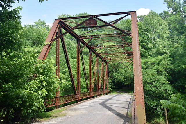
This riveted Pratt through truss has been abandoned.
Information and Findings From DHPA Historic Bridge SurveyBridge History and Significance Previous Structure ( 18 - 1913) - For previous structure, see "Alex Cox Road Bridge" (timber) County records suggest an earlier structure here. In September 1900, the commissioners contracted with J. A. Coleman for $147 worth of repairs to the Salt Creek Bridge on the Bedford and Williams Road. In November, the board engaged in a second and much larger contract at $1,374.96 with Coleman for repair work on the same structure. Surveyed Structure (1913 - ) Following the great spring flood of 1913, the commissioners sought an appropriation of $6,963.80 for a new bridge on the Bedford and Williams Road. In June, the Vincennes Bridge Company brought in the lowest and successful construction bid at $5,150, and in August the board sold the old structure to William Jackson for $87.50. 19-foot vertical clearance. Cut-stone abutments and pier. I floor-beams field riveted to verticals below the lower chord. #Not in M&H inventory of Aug 09. References Charles E. Jones, Lawrence County Bridge Inspection Program: Final Report (Bedford, 1973); Lawrence County Bridge Reinspection Program (Bedford, 1978). Associated Engineering Consultants, Inc., Bridge Reinspection Study and Report: Lawrence County (Nashville, 1979). bridge nameplate. Lawrence County, "Commissioners Record," P: 101, 126, 153; S: 197, 213 250. Bridge Considered Historic By Survey: Yes |
![]()
![]()
![]()
Coordinates (Latitude, Longitude):
Search For Additional Bridge Listings:
Bridgehunter.com: View listed bridges within 0.5 miles (0.8 kilometers) of this bridge.
Bridgehunter.com: View listed bridges within 10 miles (16 kilometers) of this bridge.
Additional Maps:
Google Streetview (If Available)
GeoHack (Additional Links and Coordinates)
Apple Maps (Via DuckDuckGo Search)
Apple Maps (Apple devices only)
Android: Open Location In Your Map or GPS App
Flickr Gallery (Find Nearby Photos)
Wikimedia Commons (Find Nearby Photos)
Directions Via Sygic For Android
Directions Via Sygic For iOS and Android Dolphin Browser
USGS National Map (United States Only)
Historical USGS Topo Maps (United States Only)
Historic Aerials (United States Only)
CalTopo Maps (United States Only)

© Copyright 2003-2024, HistoricBridges.org. All Rights Reserved. Disclaimer: HistoricBridges.org is a volunteer group of private citizens. HistoricBridges.org is NOT a government agency, does not represent or work with any governmental agencies, nor is it in any way associated with any government agency or any non-profit organization. While we strive for accuracy in our factual content, HistoricBridges.org offers no guarantee of accuracy. Information is provided "as is" without warranty of any kind, either expressed or implied. Information could include technical inaccuracies or errors of omission. Opinions and commentary are the opinions of the respective HistoricBridges.org member who made them and do not necessarily represent the views of anyone else, including any outside photographers whose images may appear on the page in which the commentary appears. HistoricBridges.org does not bear any responsibility for any consequences resulting from the use of this or any other HistoricBridges.org information. Owners and users of bridges have the responsibility of correctly following all applicable laws, rules, and regulations, regardless of any HistoricBridges.org information.
![]()