

View Information About HSR Ratings
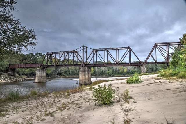
Erected in 1905, this unique bridge includes a span made from four truss lines of an older Whipple truss bridge. The Whipple truss is the most unique span on this bridge. It is composed of one pair of truss lines on either side of the railroad tracks. By taking two Whipple truss spans and turning them into a single doubled-up Whipple truss span, the railroad was able to increase the load capacity of the span to meet the increased needs of the time, without having to scrap the lighter weight Whipple truss. It is not known where the Whipple trusses came from, and the age and original builder of the Whipple truss is unknown, but it could date to the 1880s based on style. From west to east, this bridge is configured as follows: A long timber trestle approach, a 100 foot through plate girder span (built by the American Bridge Company, per plaque on outside of girder), a 215 foot through truss swing span (assumed to be built by the American Bridge Company), a 215 foot Whipple truss span composed of a pair of truss lines on each side (reassembled by the Missouri Valley Bridge & Iron Company), and lastly another timber trestle approach. The substructure of the bridge was built by Kohmann and McMurry of Kansas City, Missouri.

Above: Historical photos showing bridge construction, from 1906 Bridgemen's Magazine.


![]()
![]()
![]()
Coordinates (Latitude, Longitude):
Search For Additional Bridge Listings:
Bridgehunter.com: View listed bridges within 0.5 miles (0.8 kilometers) of this bridge.
Bridgehunter.com: View listed bridges within 10 miles (16 kilometers) of this bridge.
Additional Maps:
Google Streetview (If Available)
GeoHack (Additional Links and Coordinates)
Apple Maps (Via DuckDuckGo Search)
Apple Maps (Apple devices only)
Android: Open Location In Your Map or GPS App
Flickr Gallery (Find Nearby Photos)
Wikimedia Commons (Find Nearby Photos)
Directions Via Sygic For Android
Directions Via Sygic For iOS and Android Dolphin Browser
USGS National Map (United States Only)
Historical USGS Topo Maps (United States Only)
Historic Aerials (United States Only)
CalTopo Maps (United States Only)

© Copyright 2003-2024, HistoricBridges.org. All Rights Reserved. Disclaimer: HistoricBridges.org is a volunteer group of private citizens. HistoricBridges.org is NOT a government agency, does not represent or work with any governmental agencies, nor is it in any way associated with any government agency or any non-profit organization. While we strive for accuracy in our factual content, HistoricBridges.org offers no guarantee of accuracy. Information is provided "as is" without warranty of any kind, either expressed or implied. Information could include technical inaccuracies or errors of omission. Opinions and commentary are the opinions of the respective HistoricBridges.org member who made them and do not necessarily represent the views of anyone else, including any outside photographers whose images may appear on the page in which the commentary appears. HistoricBridges.org does not bear any responsibility for any consequences resulting from the use of this or any other HistoricBridges.org information. Owners and users of bridges have the responsibility of correctly following all applicable laws, rules, and regulations, regardless of any HistoricBridges.org information.
![]()