

View Information About HSR Ratings
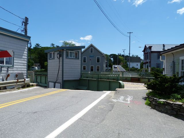
The South Bristol Bridge is an example of a small through plate girder bobtail swing bridge. A bobtail swing bridge is not symmetrical, and instead has one end shorter than the other. The bobtail design is often used in situations where the swing pier will be located on the shore, rather than in the middle of the waterway. This is indeed the case with the South Bristol Bridge. The longer half of the bridge extends over the waterway, while the shorter end extends over land away from the waterway, only as far as is needed to provide enough counterweight to balance the bridge out. On the South Bristol Bridge, the metal grate deck is filled with concrete at the shorter end to provide counterweight. Additionally, metal blocks rest inside the girders, apparently added at some time to provide additional counterweight balance. The bobtail design, is generally less common on a nationwide scale, although Maine does have more than one example. Also, bobtail swing bridges represent a more complex engineering achievement, since they have an asymmetrical design and must be carefully counterweighted to be in proper balance.
Movable bridges with historic value are a rare type nationwide. Movable bridges are traditionally costly to construct and maintain, so the number constructed in the first place was likely limited. Many movable bridges cross waters controlled by the coast guard, which places tough restrictions on movable bridges, and sometimes mandates their replacement. Maine in particular has very few movable bridges, particularly those that still operate. Most of them are small movable bridges, like the South Bristol Bridge. The South Bristol Bridge does still operate; indeed it operates very frequently. The bridge operates as much as 1600 times per month and over 800 openings annually. This is reported to be one of the most frequently operated movable bridges in the country.
Despite the bridge's historic significance and rarity, demolition and replacement has been planned for this bridge. While there has been some local interest in preserving the historic bridge instead, demolition remains the plan. At least one newspaper article described the proposed replacement as a "heel trunnion bascule" type of bridge. This is a little misleading. While the bridge does have two points of rotation like a heel-trunnion, it does not follow the design patented by famous engineer Joseph Baermann Strauss that is traditionally described as the heel trunnion type. Instead, the bridge follows an ancient European bascule design that is quite common in the Netherlands. This bascule design very well may have been the inspiration for Strauss's patented heel-trunnion design, since they do share some similarities, however the heel trunnion stands on its own as a unique variety refined and improved by Strauss, and different from the Dutch bascule bridges. A set of renderings courtesy of Project Manager Stephen Bodge of MaineDOT showing the proposed South Bristol replacement can be seen here. The proposed Dutch style bascule bridge will make a radically different architectural statement than the existing bridge, which is firmly rooted in Maine's traditional design of movable bridges.
![]()
![]()
![]()

![]()
This historic bridge has been demolished. This map is shown for reference purposes only.
Coordinates (Latitude, Longitude):
Search For Additional Bridge Listings:
Bridgehunter.com: View listed bridges within 0.5 miles (0.8 kilometers) of this bridge.
Bridgehunter.com: View listed bridges within 10 miles (16 kilometers) of this bridge.
Additional Maps:
Google Streetview (If Available)
GeoHack (Additional Links and Coordinates)
Apple Maps (Via DuckDuckGo Search)
Apple Maps (Apple devices only)
Android: Open Location In Your Map or GPS App
Flickr Gallery (Find Nearby Photos)
Wikimedia Commons (Find Nearby Photos)
Directions Via Sygic For Android
Directions Via Sygic For iOS and Android Dolphin Browser
USGS National Map (United States Only)
Historical USGS Topo Maps (United States Only)
Historic Aerials (United States Only)
CalTopo Maps (United States Only)

© Copyright 2003-2024, HistoricBridges.org. All Rights Reserved. Disclaimer: HistoricBridges.org is a volunteer group of private citizens. HistoricBridges.org is NOT a government agency, does not represent or work with any governmental agencies, nor is it in any way associated with any government agency or any non-profit organization. While we strive for accuracy in our factual content, HistoricBridges.org offers no guarantee of accuracy. Information is provided "as is" without warranty of any kind, either expressed or implied. Information could include technical inaccuracies or errors of omission. Opinions and commentary are the opinions of the respective HistoricBridges.org member who made them and do not necessarily represent the views of anyone else, including any outside photographers whose images may appear on the page in which the commentary appears. HistoricBridges.org does not bear any responsibility for any consequences resulting from the use of this or any other HistoricBridges.org information. Owners and users of bridges have the responsibility of correctly following all applicable laws, rules, and regulations, regardless of any HistoricBridges.org information.
![]()