

View Information About HSR Ratings
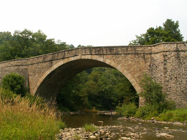
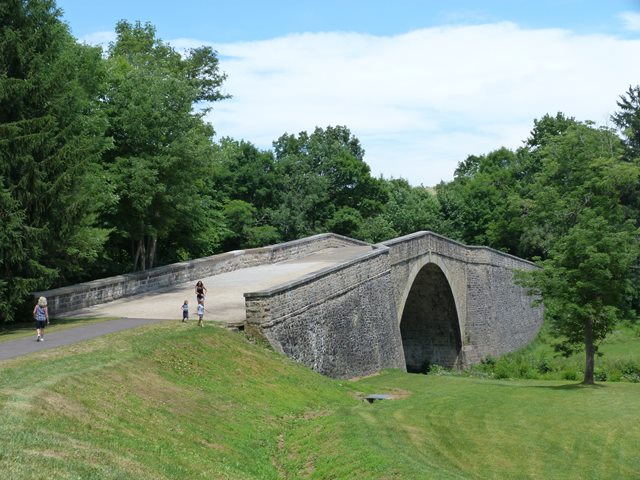
Among the oldest surviving bridges in the country is this magnificent stone arch bridge that is so old that it was built during the the time of the War of 1812! At the time it was built it was a monumental engineering achievement for the United States and it was the longest single span bridge in the country. The bridge was part of the National Road. If Route 66 is considered the mother road, than the National Road would be the father road. It was the main route to travel west past the Appalachians, and as such was a critical transportation feature for the early United States. This bridge stands today as a major remnant of that roadway. As an arch bridge of any construction date, the 80 foot long, 30 foot high span is very impressive and noteworthy. The span length, combined with the bridge's construction date, makes this one of the most important stone arch bridges in the country. The Casselman Bridge is listed as a National Historic Landmark, which is a distinction that very few bridges have earned. The bridge has been preserved in place for pedestrian use in a park setting. US-40, the modern equivalent of the National Road, runs on modern alignment just south of this bridge. The US-40 Bridge is worth a look too.
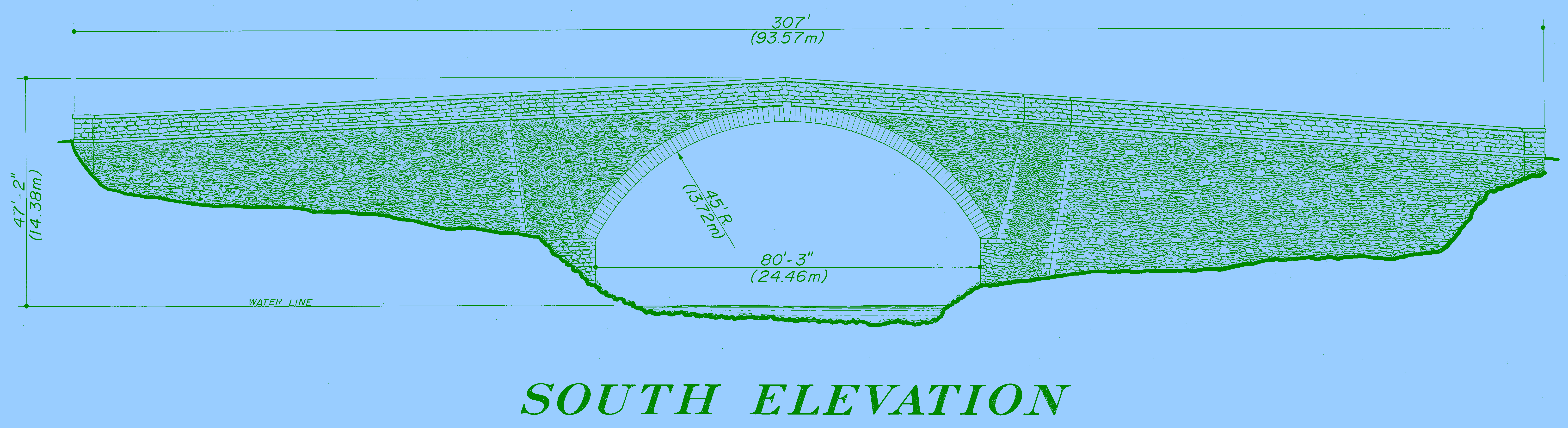
Information and Findings From Pennsylvania's Historic Bridge InventoryDescription The Casselman Bridge, a large single-arch structure erected in 1813, extends some 354', spanning the Casselman River. Stones are laid in an a random-coursed ashlar pattern. The height of the bridge is approximately 30' from the crown of the arch to the waterline below, while its width between the abutments is about 48'. The Casselman Bridge is in relatively sound condition. In 1911 the bridge was repaired, but today remains essentially unchanged from the time of its construction. Six steel columns support the structure on either side and do not overtly detract from its appearance. The old National Road has been supplanted by the new Route 40 and in actuality no longer exists. There is, however, a small portion of the old National Road on either side of the entrances to the Casselman Bridge. This area surrounding the bridge has been made into a public park with picnic tables in the area adjacent to the bridge. Statement of Significance The National Road was the Federal government's first experiment in public highway construction. Congress authorized the road's building in 1806 and by 1818 the road stretched from Cumberland, Maryland, to the Ohio River in what is today West Virginia. Because of the controversy regarding the propriety of the national government's participation in public road construction, the project was halted until 1828. The old National Road provided ready access to the trans-Appalachian region and greatly stimulated its settlement and growth. The Casselman Bridge was an integral part of the National Road, and at its completion, possessed the largest stone arch in the United States. Built about 1813, the bridge remains a splendid paradigm of early American engineering prowess. A traveler of the period spoke of it in laudatory terms calling it simply "superb." Bridge Considered Historic By Survey: Yes |
This bridge is tagged with the following special condition(s): Unorganized Photos
![]()
![]()
![]()
![]()
Coordinates (Latitude, Longitude):
Search For Additional Bridge Listings:
Bridgehunter.com: View listed bridges within 0.5 miles (0.8 kilometers) of this bridge.
Bridgehunter.com: View listed bridges within 10 miles (16 kilometers) of this bridge.
Additional Maps:
Google Streetview (If Available)
GeoHack (Additional Links and Coordinates)
Apple Maps (Via DuckDuckGo Search)
Apple Maps (Apple devices only)
Android: Open Location In Your Map or GPS App
Flickr Gallery (Find Nearby Photos)
Wikimedia Commons (Find Nearby Photos)
Directions Via Sygic For Android
Directions Via Sygic For iOS and Android Dolphin Browser
USGS National Map (United States Only)
Historical USGS Topo Maps (United States Only)
Historic Aerials (United States Only)
CalTopo Maps (United States Only)

© Copyright 2003-2024, HistoricBridges.org. All Rights Reserved. Disclaimer: HistoricBridges.org is a volunteer group of private citizens. HistoricBridges.org is NOT a government agency, does not represent or work with any governmental agencies, nor is it in any way associated with any government agency or any non-profit organization. While we strive for accuracy in our factual content, HistoricBridges.org offers no guarantee of accuracy. Information is provided "as is" without warranty of any kind, either expressed or implied. Information could include technical inaccuracies or errors of omission. Opinions and commentary are the opinions of the respective HistoricBridges.org member who made them and do not necessarily represent the views of anyone else, including any outside photographers whose images may appear on the page in which the commentary appears. HistoricBridges.org does not bear any responsibility for any consequences resulting from the use of this or any other HistoricBridges.org information. Owners and users of bridges have the responsibility of correctly following all applicable laws, rules, and regulations, regardless of any HistoricBridges.org information.
![]()