

View Information About HSR Ratings
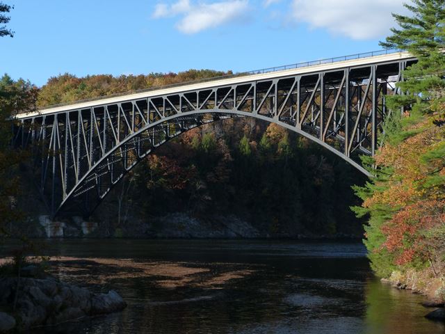
This is a landmark example of a steel deck arch bridge. Its steel arch superstructure is itself graceful and beautiful. Additionaly, handsome detailing of the concrete abutments that include decorative pillars that rise above the deck add to the aesthetic qualities of the bridge.
The bridge is structurally unusual. Normally, arch bridges are not continuous, but apparently this bridge does function like a continuous bridge. It was, when constructed, built as a two-hinged arch bridge. To a casual viewer, it still looks like a two-hinged arch bridge with massive pins visible at the skewbacks. However, as detailed in the Historic Bridge Inventory, the hinges were converted to fixed elements after construction was completed. As such, the bridge apparently should be properly classified as hingeless.
The bridge is also noteworthy as a historic bridge in Massachusetts that has been preserved. A rehabilitation project in 1992 was executed in a way that preserved the historic integrity of the bridge.
The bridge itself is not only scenic and beautiful, but the surrounding landscape is equally impressive. The views from the bridge are worth seeing, as are the views of the bridge itself, easily had from the nearby historic Mineral Road Bridge.

Above: Historical photo showing newly completed bridge. Photo Courtesy, Cynthia Stulpin.
Information and Findings From Massachusetts's Historic Bridge InventoryStructure Description Designer: Structure Type Steel, 3 span continuous spandrel - braced deck arch with a parabolic lower chord, very slightly arched upper chord, Pratt -type spandrel bracing. Superstructure fixed against horizontal movement at both piers - reactions were jacked into the superstructure at the conclusion of the steel erection, and the hinged arches were then fixed against further horizontal movement. Both ends of the superstructure bear on roller bearing nests on the abutments (for longitudinal expansion/contraction). Vertical ties at both abutments to counter any reversal of vertical reaction - their primary purpose was to hold down ends of the bridge during the cantilever erection process. K-brace lateral systems, both upper and lower. Cross frame sway bracing at each panel point. Plate girder floorbeams, I-beam stringers, concrete slab deck. East abutment is a reinforced concrete cell type. The West abutment is a reinforced concrete gravity type. The 1992 rehabilitation included the replacement of the deck with a new concrete deck overlaid with latex modified concrete; steel repairs; restoration of the original pylons and lamp standards; restoration of the original molded concrete fascia; adding a modern crash-tested curb mounted railing to permit the retention of the ornamental "Boston-type" metal railings. History of Bridge The French King Bridge was conceived as part of a MassHighway project to relocate a particularly hazardous 7 mile stretch of the old Mohawk Trail Highway (State Route 2) between Erving and Greenfield. The old route had wound through the villages of Millers Falls and Turners Falls on a course marked by steep grades, sharp curves, narrow bridges, right angle turns, and a pair of at-grade railroad crossings. The relocated State Route 2 now runs north of both villages on an alignment whose principal challenge was the crossing of the precipitous Connecticut River gorge near the French King Rock (so named by the French officer of an Indian scouting party during the French and Indian Wars). A low-level crossing of the gorge was considered, but was soon dropped in favor of a high-level crossing. The selection of a specific structural type for this high-level bridge was based on the Department's desire to fit the bridge into this dramatic setting, while responding to such factors as: the height and steepness of the gorge's banks; the presence of rock suitable for foundations only a few feet below the ground's surface; and the relative narrowness, irregular depth, rocky bottom, and swift current of the river here. The graceful 3-span arch design which resulted takes advantage of the favorable foundation conditions (critical for an arch) while it avoided the construction of either permanent piers or temporary falsework in the river itself since the bridge was erected by the cantilever method. Construction began in September of 1931; the bridge was completed (at a cost of $385,000.00) and opened to travel on September 10, 1932. The American Institute of Steel Construction named the French King Bridge the most beautiful steel bridge of its class erected in America in 1932. Significance of Bridge The French King Bridge is one of four known steel deck arch bridges identified in the MassHighway database, and its main span is the sixth longest span of all the bridges listed in the database. It is of engineering interest as an unusual development of the uncommon three-span, "cantilever arch" bridge type, in that definite reactions were jacked into its steel work at the conclusion of construction, resulting in a bridge which is structurally continuous across four supports. The bridge was the crucial link in the establishment of a safe and efficient highway, which replaced a very dangerous section of road between Erving and Greenfield in the early 1930's. The French King Bridge won the American Institute of Steel Construction 1932 First Place, Class B, Most Beautiful Steel Bridge Award. The 1992 rehabilitation project won the 1993 Massachusetts Historic Commission Preservation Award. Bridge Considered Historic By Survey: Yes |
![]()
![]()
![]()
Coordinates (Latitude, Longitude):
Search For Additional Bridge Listings:
Bridgehunter.com: View listed bridges within 0.5 miles (0.8 kilometers) of this bridge.
Bridgehunter.com: View listed bridges within 10 miles (16 kilometers) of this bridge.
Additional Maps:
Google Streetview (If Available)
GeoHack (Additional Links and Coordinates)
Apple Maps (Via DuckDuckGo Search)
Apple Maps (Apple devices only)
Android: Open Location In Your Map or GPS App
Flickr Gallery (Find Nearby Photos)
Wikimedia Commons (Find Nearby Photos)
Directions Via Sygic For Android
Directions Via Sygic For iOS and Android Dolphin Browser
USGS National Map (United States Only)
Historical USGS Topo Maps (United States Only)
Historic Aerials (United States Only)
CalTopo Maps (United States Only)

© Copyright 2003-2024, HistoricBridges.org. All Rights Reserved. Disclaimer: HistoricBridges.org is a volunteer group of private citizens. HistoricBridges.org is NOT a government agency, does not represent or work with any governmental agencies, nor is it in any way associated with any government agency or any non-profit organization. While we strive for accuracy in our factual content, HistoricBridges.org offers no guarantee of accuracy. Information is provided "as is" without warranty of any kind, either expressed or implied. Information could include technical inaccuracies or errors of omission. Opinions and commentary are the opinions of the respective HistoricBridges.org member who made them and do not necessarily represent the views of anyone else, including any outside photographers whose images may appear on the page in which the commentary appears. HistoricBridges.org does not bear any responsibility for any consequences resulting from the use of this or any other HistoricBridges.org information. Owners and users of bridges have the responsibility of correctly following all applicable laws, rules, and regulations, regardless of any HistoricBridges.org information.
![]()