

View Information About HSR Ratings

Above: Photo of Troeger's conceptual drawing of the Burton Street Interchange (document housed in Michigan Archives)
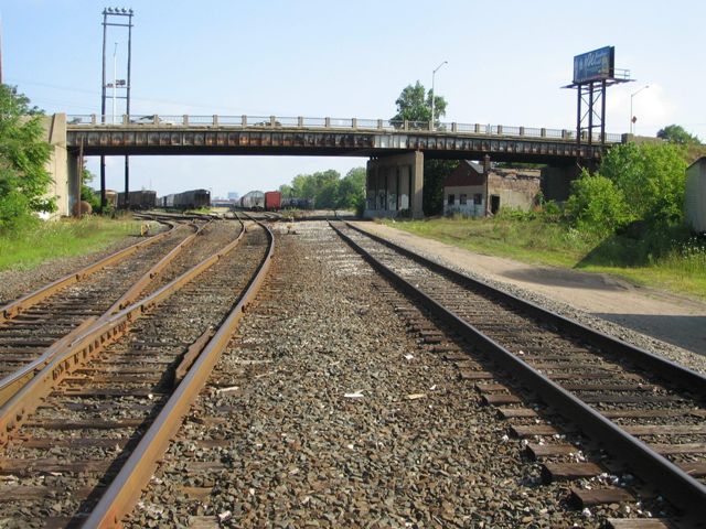
The Burton Street US-131 Interchange is a system of bridges and ramps which consists of a US-131 overpass, a railroad overpass, and associated entrance and exit ramps which connect with either Burton Street or adjacent Century Avenue. The entire collection of bridges and ramps should be considered historically and technologically significant as one of the more complete and complex engineering efforts found on the US-131 expressway. There are other interchanges along this section of freeway in Grand Rapids, but the other examples lack the historic integrity, and/or are less complex. The interchange currently is not evaluated as eligible for the National Register of Historic Places, but such a finding should be considered for this interchange, which now meets the 50 year requirement for eligibility consideration.
The original design of the interchange with US-131 originally included two methods for entering southbound US-131, one being a ramp leading south of Burton Street, the other being a ramp leading from Century Avenue. This ramp does not exist today. It is not known if this ramp was never built or if it was removed. It would not be something welcome on a modern freeway because it was somewhat redundant and would have increased the locations from which traffic merged onto US-131, which would be a safety concern.
Note: This particular page is dedicated to a discussion and documentation of the Railroad Overpass. The Burton Street Railroad Overpass, while part of the complete interchange system and a contributing structure in terms of the interchange's historic significance, has been given a separate page for clarity and organization. For documentation of the remainder of the interchange, including the ramps and the US-131 Bridge, visit the page for the Burton Street US-131 Bridge.
The Burton Street Railroad Overpass retains its original R4 railings, and unlike the US-131 bridge next to it, modern Armco guardrails have not been added to this bridge. This is probably because although the bridge would have been built as a State project, the bridge today is county-owned unlike the US-131 overpass which is MDOT owned. In addition to its contributions to the heritage value of the interchange, the railroad overpass is also individually noteworthy for several reasons. First, beams on the bridge are riveted built-up i-beams, which are far less common on stringer bridges than rolled beams. In addition, the bridge is a good example of a stringer that includes a pin and hanger joint design. The pin-and-hanger system was commonly used in the mid-20th Century in Michigan and other states. With a pin-and-hanger system, the ends of the stringers are not located over the piers like they would be in a traditional simple-spanning stringer bridge. One of the benefits of the system is that because the expansion joint is located over the pier, any water and salt that might drain through the joint does not land on the pier, so substructure deterioration rate is greatly reduced. Pin-and-hanger systems fell out of favor by the later part of the 20th Century because the pins were previously used to make it easier to do analysis for the design of the bridge. With today's computer technology however, this is no longer an issue. The pins also tend to require additional maintenance versus a standard stringer bridge. The Burton Street Railroad Overpass is no exception, since new stainless steel pins appear to have been installed on the bridge. From a historic significance standpoint however, pin-and-hanger systems are of interest because they are an unusual and relatively short-lived development in bridge design.
Michigan State Archives has a set of conceptual architectural drawings that were created during the formation of Michigan's Interstate Highway System. These are different from structural bridge and road plan sheets; they are instead artistic renderings that were created during the initial planning process to design the overall visual/aesthetic appearance of the highway system. The collection is called the Troeger Collection after Philip Troeger who created them for the Michigan State Highway Department.
Some of the Troeger drawings are not specific to a particular location or bridge and are instead generalized concepts, such as what a curved t-beam bridge should look like in depressed (cut) sections of freeway, or what the architectural detailing on bridge abutments should look like. Other sheets are bridge specific. Just by chance, the Burton Street interchange and overpasses are among the specific drawings.
Photos of the Troeger drawing for the Burton Street Interchange are available in the photo gallery.
This bridge is tagged with the following special condition(s): Unorganized Photos
![]()
![]()
![]()
![]()
![]()
Coordinates (Latitude, Longitude):
Search For Additional Bridge Listings:
Bridgehunter.com: View listed bridges within 0.5 miles (0.8 kilometers) of this bridge.
Bridgehunter.com: View listed bridges within 10 miles (16 kilometers) of this bridge.
Additional Maps:
Google Streetview (If Available)
GeoHack (Additional Links and Coordinates)
Apple Maps (Via DuckDuckGo Search)
Apple Maps (Apple devices only)
Android: Open Location In Your Map or GPS App
Flickr Gallery (Find Nearby Photos)
Wikimedia Commons (Find Nearby Photos)
Directions Via Sygic For Android
Directions Via Sygic For iOS and Android Dolphin Browser
USGS National Map (United States Only)
Historical USGS Topo Maps (United States Only)
Historic Aerials (United States Only)
CalTopo Maps (United States Only)

© Copyright 2003-2024, HistoricBridges.org. All Rights Reserved. Disclaimer: HistoricBridges.org is a volunteer group of private citizens. HistoricBridges.org is NOT a government agency, does not represent or work with any governmental agencies, nor is it in any way associated with any government agency or any non-profit organization. While we strive for accuracy in our factual content, HistoricBridges.org offers no guarantee of accuracy. Information is provided "as is" without warranty of any kind, either expressed or implied. Information could include technical inaccuracies or errors of omission. Opinions and commentary are the opinions of the respective HistoricBridges.org member who made them and do not necessarily represent the views of anyone else, including any outside photographers whose images may appear on the page in which the commentary appears. HistoricBridges.org does not bear any responsibility for any consequences resulting from the use of this or any other HistoricBridges.org information. Owners and users of bridges have the responsibility of correctly following all applicable laws, rules, and regulations, regardless of any HistoricBridges.org information.
![]()