

View Information About HSR Ratings
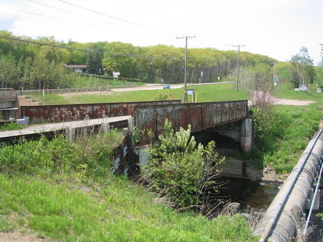
At first glance, this bridge looks like a typical scenario: it looks like a former railroad line and its plate girder bridge have been converted to a trail available for ORVs, snowmobiles, and non-motorized traffic. However a closer inspection seems to suggest that this is actually a former highway bridge, rather than a railroad bridge. The bridge has a fairly wide deck width (compared to a single track railroad bridge). Yet despite its width, the girders are more lightweight than many narrow, single track railroad plate girders. Double-track railroad bridges would have even more massive girders. The bridge sits on riveted steel caissons. This type of substructure is rare in railroad bridges, and in the few cases where it does occur like with the Sturgeon River Bridge, the caissons are more massive. The reality is that this bridge is more like a highway plate girder like the Woodland Road Bridge. Furthermore, north of the bridge, Lake Street lines up perfectly with this bridge, except that today, the road makes a 90 degree turn to end at US-41 just before the bridge. It stands to reason that before this current alignment of US-41, Lake Street likely continued south over this bridge. If the above assumptions are correct, than this bridge is a rare example of a highway plate girder in Michigan. Unlike some states, Michigan built very few highway plate girders. As such, surviving examples in Michigan are far more historically significant and rare on a statewide basis than this bridge type might be in another state like Pennsylvania which has more examples.
![]()
![]()
![]()
Coordinates (Latitude, Longitude):
Search For Additional Bridge Listings:
Bridgehunter.com: View listed bridges within 0.5 miles (0.8 kilometers) of this bridge.
Bridgehunter.com: View listed bridges within 10 miles (16 kilometers) of this bridge.
Additional Maps:
Google Streetview (If Available)
GeoHack (Additional Links and Coordinates)
Apple Maps (Via DuckDuckGo Search)
Apple Maps (Apple devices only)
Android: Open Location In Your Map or GPS App
Flickr Gallery (Find Nearby Photos)
Wikimedia Commons (Find Nearby Photos)
Directions Via Sygic For Android
Directions Via Sygic For iOS and Android Dolphin Browser
USGS National Map (United States Only)
Historical USGS Topo Maps (United States Only)
Historic Aerials (United States Only)
CalTopo Maps (United States Only)

© Copyright 2003-2024, HistoricBridges.org. All Rights Reserved. Disclaimer: HistoricBridges.org is a volunteer group of private citizens. HistoricBridges.org is NOT a government agency, does not represent or work with any governmental agencies, nor is it in any way associated with any government agency or any non-profit organization. While we strive for accuracy in our factual content, HistoricBridges.org offers no guarantee of accuracy. Information is provided "as is" without warranty of any kind, either expressed or implied. Information could include technical inaccuracies or errors of omission. Opinions and commentary are the opinions of the respective HistoricBridges.org member who made them and do not necessarily represent the views of anyone else, including any outside photographers whose images may appear on the page in which the commentary appears. HistoricBridges.org does not bear any responsibility for any consequences resulting from the use of this or any other HistoricBridges.org information. Owners and users of bridges have the responsibility of correctly following all applicable laws, rules, and regulations, regardless of any HistoricBridges.org information.
![]()