

View Information About HSR Ratings
This bridge's unusually wide width for a 1917 bridge is testimony to the fact that this was once the main road through Iron River. In 1998, US-2 was realigned to the north to carry the majority of traffic passing through Iron River. However, this bridge remains as a historic reminder of Genesee Street's history as the main road through town, and it remains a gateway to the traditional downtown area.
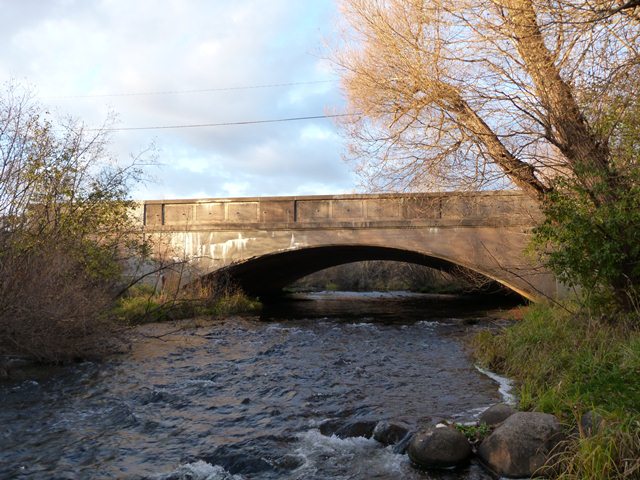
Very few of Michigan's small population of concrete arch bridges have been preserved, and the population has declined due to demolition in recent years. This bridge is an increasing rare example of its type in Michigan and thus it is increasingly important that this bridge be preserved. At this time, the bridge appears to be in good condition, making it an outstanding candidate for preservation efforts.
Information and Findings From Michigan Historic Sites OnlineNarrative Description Included among the twelve Iron County structures in the Survey Sample is this graceful arch bridge in the city of Iron River. The Iron River Bridge carries US-2 immediately east of the city's central business district. The bridge is a 55 foot, filled spandrel arch, with earth fill and an asphalt-surfaced roadway that is flanked on both sides by grassy strips. The elliptically shaped arch springs from massive concrete abutments. It features tapered arch ring, which is corbeled slightly from the spandrel on each side; the guardrails are solid concrete, with incised rectangular panels. Other than the installation of Armco guardrails on wooden posts inside the original concrete walls, the Iron River Bridge remains in essentially unaltered condition. Statement of Significance In March 1880 R.L. Seldon and his son opened the Iron River Mine on the bank of the Iron River. The mine rapidly prospered, and in 1881 Donald and Alexander McKinnon platted the town of Iron River nearby on the river's west bank, in anticipation of the influx of miners to the area. The town too flourished in the 1880s, soon expanding across the river. As the only incorporated village in newly formed Iron County, it was designated the county seat in 1885. Iron river later lost the county seat to Crystal Falls and eventually lost its economic base after a mining depression in the wake of the Panic of 1893. After the turn of the century, however, Iron River again flourished with the resurgence of the mining industry. The village built a new sewage system in 1905 and an electric network in 1908. Flowing through the center of town, the Iron River had historically formed the major impediment to travel between the town's two sides. The first bridge was built across the Iron River here soon after the village's platting in the 19 century. But population growth after 1900 and the designation of a state trunk line through town in 1913 placed additional strain on the existing bridge. By the mid-1910s, the village had begun to consider a replacement span for the Iron River Bridge. At the town's request, MSHD engineers designed this 55 foot arch bridge, designated it Trunk Line Bridge No. 191, and awarded a contract for its construction to the Hoose and Person construction Company of Iron Mountain. The contractors completed the structure in 1917 for a total cost of $20,343.16, of which the village paid over $13,000. Since its completion, the Iron River Bridge has carried increasingly heavy inner-city and regional traffic. In the 1920s the route was incorporated into US-2, and in 1926 Iron River was incorporated as a city, but the bridge functions in essentially unaltered condition. The Iron River Bridge is historically significant as the principal river crossing in the city and an important structure on the Upper Peninsula's most important highway. It is technologically significant as an unaltered, relatively early example of concrete arch bridge construction by the state highway department -- one of the first dozen such structures built by MSHD. The historic centerpiece of vehicular traffic in this city, the Iron River Bridge is eligible for the National Register of Historic Places. In 1998, US-2 was relocated to the north , and this bridge now carries local traffic on Genesee Street which is the main street in Iron River. |
![]()
![]()
![]()
Coordinates (Latitude, Longitude):
Search For Additional Bridge Listings:
Bridgehunter.com: View listed bridges within 0.5 miles (0.8 kilometers) of this bridge.
Bridgehunter.com: View listed bridges within 10 miles (16 kilometers) of this bridge.
Additional Maps:
Google Streetview (If Available)
GeoHack (Additional Links and Coordinates)
Apple Maps (Via DuckDuckGo Search)
Apple Maps (Apple devices only)
Android: Open Location In Your Map or GPS App
Flickr Gallery (Find Nearby Photos)
Wikimedia Commons (Find Nearby Photos)
Directions Via Sygic For Android
Directions Via Sygic For iOS and Android Dolphin Browser
USGS National Map (United States Only)
Historical USGS Topo Maps (United States Only)
Historic Aerials (United States Only)
CalTopo Maps (United States Only)

© Copyright 2003-2024, HistoricBridges.org. All Rights Reserved. Disclaimer: HistoricBridges.org is a volunteer group of private citizens. HistoricBridges.org is NOT a government agency, does not represent or work with any governmental agencies, nor is it in any way associated with any government agency or any non-profit organization. While we strive for accuracy in our factual content, HistoricBridges.org offers no guarantee of accuracy. Information is provided "as is" without warranty of any kind, either expressed or implied. Information could include technical inaccuracies or errors of omission. Opinions and commentary are the opinions of the respective HistoricBridges.org member who made them and do not necessarily represent the views of anyone else, including any outside photographers whose images may appear on the page in which the commentary appears. HistoricBridges.org does not bear any responsibility for any consequences resulting from the use of this or any other HistoricBridges.org information. Owners and users of bridges have the responsibility of correctly following all applicable laws, rules, and regulations, regardless of any HistoricBridges.org information.
![]()