

View Information About HSR Ratings
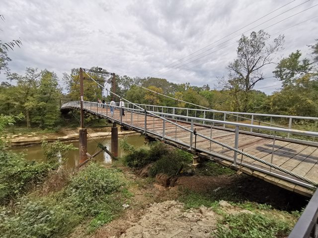
This is a large swinging style suspension bridge with riveted, latticed, and laced suspension towers. The bridge was built in 1905 using a patented design of timber anchorage. It appears the patented anchorage no longer remains as the anchorage seen today looks newer and the main cable does not appear to be original. The floorbeams on the bridge appear to date to after 1950 as well because they have USS (United States Steel) logos on them. USS didn't mark their logo on steel until around 1950. At least some of the unusual bent eyebar rods that form the suspenders for the bridge may be original as the design as unusual and archaic. Reportedly a local blacksmith, De Witt Mason, forged these rods.
The builder of the bridge is not clear. The sign at the bridge says the "residents of Hinds and Rankin Counties" while Bridgehunter.com lists W.H. Groome and Son. A historical news article about the bridge lists that a contract was let to Charles P. Matthews. Yet a further post on Bridgehunter.com from Kay Davis stated the following: My grandfather Ed Matthews drew the plans for the bridge. He and his father, Charles P. Matthews didn't get the contract, but the company that did had to hire Ed Matthews to build the bridge!
It is not known who the actual awarded contractor was.
![]()
![]()
![]()
Coordinates (Latitude, Longitude):
Search For Additional Bridge Listings:
Bridgehunter.com: View listed bridges within 0.5 miles (0.8 kilometers) of this bridge.
Bridgehunter.com: View listed bridges within 10 miles (16 kilometers) of this bridge.
Additional Maps:
Google Streetview (If Available)
GeoHack (Additional Links and Coordinates)
Apple Maps (Via DuckDuckGo Search)
Apple Maps (Apple devices only)
Android: Open Location In Your Map or GPS App
Flickr Gallery (Find Nearby Photos)
Wikimedia Commons (Find Nearby Photos)
Directions Via Sygic For Android
Directions Via Sygic For iOS and Android Dolphin Browser
USGS National Map (United States Only)
Historical USGS Topo Maps (United States Only)
Historic Aerials (United States Only)
CalTopo Maps (United States Only)

© Copyright 2003-2024, HistoricBridges.org. All Rights Reserved. Disclaimer: HistoricBridges.org is a volunteer group of private citizens. HistoricBridges.org is NOT a government agency, does not represent or work with any governmental agencies, nor is it in any way associated with any government agency or any non-profit organization. While we strive for accuracy in our factual content, HistoricBridges.org offers no guarantee of accuracy. Information is provided "as is" without warranty of any kind, either expressed or implied. Information could include technical inaccuracies or errors of omission. Opinions and commentary are the opinions of the respective HistoricBridges.org member who made them and do not necessarily represent the views of anyone else, including any outside photographers whose images may appear on the page in which the commentary appears. HistoricBridges.org does not bear any responsibility for any consequences resulting from the use of this or any other HistoricBridges.org information. Owners and users of bridges have the responsibility of correctly following all applicable laws, rules, and regulations, regardless of any HistoricBridges.org information.
![]()