

View Information About HSR Ratings
2018 Update: Steven Riley contacted HistoricBridges.org with a correction of information from the Historic Bridge Inventory as follows: I noticed an error on your article about the Georgia City Bridge now at King Jack Park in Webb City, Mo. Originally it was not located on CR 223. It was located on CR 270 East of Asbury. I know this because it came from my farm. I grew up around this bridge and know it well. I have written a book about John Guinn and Georgia City. Included is a section on the bridge and its removal to Webb City. My dad along with a county commissioner started a group to preserve it in place then it was moved to Webb City.
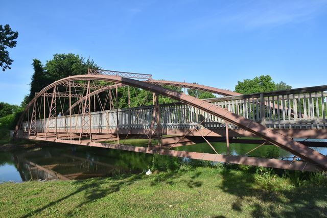
Built in 1871, this bridge was originally located on CR-223 over the Spring River in Jasper County, about 3.3 miles southeast of Asbury. In its original location, this bridge was supplemented with two unusual pony truss spans in 1885. More recently, after sitting abandoned for many years, the bowstring truss was relocated and preserved for pedestrian use here in this park setting.
This bridge is among the oldest surviving dated works of the prolific Wrought Iron Bridge Company. It is also one of the few surviving examples of the company's patented column bowstring truss design that uses Phoenix columns. Most surviving bowstrings by this company use a top chord column that resembles a Keystone column. Use of the round-shaped Phoenix columns is far more rare. That this bridge uses genuine Phoenix columns is confirmed by the Phoenix Iron name rolled into the columns.
This bridge is tagged with the following special condition(s): Phoenix Columns
![]()
![]()
![]()
Coordinates (Latitude, Longitude):
Search For Additional Bridge Listings:
Bridgehunter.com: View listed bridges within 0.5 miles (0.8 kilometers) of this bridge.
Bridgehunter.com: View listed bridges within 10 miles (16 kilometers) of this bridge.
Additional Maps:
Google Streetview (If Available)
GeoHack (Additional Links and Coordinates)
Apple Maps (Via DuckDuckGo Search)
Apple Maps (Apple devices only)
Android: Open Location In Your Map or GPS App
Flickr Gallery (Find Nearby Photos)
Wikimedia Commons (Find Nearby Photos)
Directions Via Sygic For Android
Directions Via Sygic For iOS and Android Dolphin Browser
USGS National Map (United States Only)
Historical USGS Topo Maps (United States Only)
Historic Aerials (United States Only)
CalTopo Maps (United States Only)

© Copyright 2003-2024, HistoricBridges.org. All Rights Reserved. Disclaimer: HistoricBridges.org is a volunteer group of private citizens. HistoricBridges.org is NOT a government agency, does not represent or work with any governmental agencies, nor is it in any way associated with any government agency or any non-profit organization. While we strive for accuracy in our factual content, HistoricBridges.org offers no guarantee of accuracy. Information is provided "as is" without warranty of any kind, either expressed or implied. Information could include technical inaccuracies or errors of omission. Opinions and commentary are the opinions of the respective HistoricBridges.org member who made them and do not necessarily represent the views of anyone else, including any outside photographers whose images may appear on the page in which the commentary appears. HistoricBridges.org does not bear any responsibility for any consequences resulting from the use of this or any other HistoricBridges.org information. Owners and users of bridges have the responsibility of correctly following all applicable laws, rules, and regulations, regardless of any HistoricBridges.org information.
![]()