

View Information About HSR Ratings
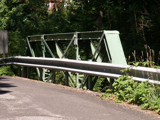
This bridge is much nicer looking than any modern bridge would be, and it is nice to see that Hunterdon County has chosen to alter this bridge than than demolish and replace it. That said, from an aesthetic and historic standpoint, the alterations made to this bridge are large, obstructive, and messy looking. Large plate substitute diagonal members have been welded on to the truss, covering up the original bridge material. These alterations are not sensitive to the historic character of the bridge and they detract greatly from the potential historic significance of this bridge.
Information and Findings From New Jersey's Historic Bridge InventoryDiscussion of Bridge The skewed 3-panel pin-connected half hip Pratt pony truss is supported on ashlar abutments with wingwalls. Loop forged eye rods form the bottom chord. Floorbeams are original. Welded additions and repairs including additional diagonals and bottom chord members, and plates welded to panel points mar the original design and type. One of over 20 half-hip pony truss spans in the county, other documented examples of the well-represented type are more complete (10WD120). The bridge is not noteworthy. Discussion of Surrounding Area The bridge carries one lane of a lightly traveled country road over a minor stream. It is located in a rural wooded setting with sparse modern development. It is adjacent to an old mill race. No above ground resources from the mill remain. Bridge Considered Historic By Survey: No |
![]()
![]()
![]()
This historic bridge has been demolished. This map is shown for reference purposes only.
Coordinates (Latitude, Longitude):
Search For Additional Bridge Listings:
Bridgehunter.com: View listed bridges within 0.5 miles (0.8 kilometers) of this bridge.
Bridgehunter.com: View listed bridges within 10 miles (16 kilometers) of this bridge.
Additional Maps:
Google Streetview (If Available)
GeoHack (Additional Links and Coordinates)
Apple Maps (Via DuckDuckGo Search)
Apple Maps (Apple devices only)
Android: Open Location In Your Map or GPS App
Flickr Gallery (Find Nearby Photos)
Wikimedia Commons (Find Nearby Photos)
Directions Via Sygic For Android
Directions Via Sygic For iOS and Android Dolphin Browser
USGS National Map (United States Only)
Historical USGS Topo Maps (United States Only)
Historic Aerials (United States Only)
CalTopo Maps (United States Only)

© Copyright 2003-2024, HistoricBridges.org. All Rights Reserved. Disclaimer: HistoricBridges.org is a volunteer group of private citizens. HistoricBridges.org is NOT a government agency, does not represent or work with any governmental agencies, nor is it in any way associated with any government agency or any non-profit organization. While we strive for accuracy in our factual content, HistoricBridges.org offers no guarantee of accuracy. Information is provided "as is" without warranty of any kind, either expressed or implied. Information could include technical inaccuracies or errors of omission. Opinions and commentary are the opinions of the respective HistoricBridges.org member who made them and do not necessarily represent the views of anyone else, including any outside photographers whose images may appear on the page in which the commentary appears. HistoricBridges.org does not bear any responsibility for any consequences resulting from the use of this or any other HistoricBridges.org information. Owners and users of bridges have the responsibility of correctly following all applicable laws, rules, and regulations, regardless of any HistoricBridges.org information.
![]()