

View Information About HSR Ratings
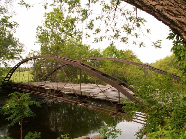
With an 1859 construction date, this bridge is among the oldest and rarest bridges in the entire country. This bridge is an extremely rare example of a Whipple Arch, which was the first of the bowstring truss bridges designs, and was designed and patented by famed engineer Squire Whipple himself. These Whipple Arch bridges feature a unique top chord that is wider at the base than it is at the top.
This bridge has a long history, as one might expect from a bridge that is nearly 150 years old. The bridge was originally constructed in 1859 to cross the Erie Canal in Brockport, New York. The bridge was a wider bridge than it is today, since in Brockport it was composed of three truss webs, rather than the two seen today. In other words, it was a wider bridge that was divided into two halves by a center truss/arch, like the Halsted Street Bridge in Chicago. The bridge remained in use in Brockport until around 1880, when it was relocated to a crossing east of Brockport. It was during this move that the bridge was changed into the two truss/arch design seen on the bridge today. The bridge remained in this location until around 1910 when it was acquired by Ehrmentraut and relocated to its current location.
The bridge has remained in its current location with little alteration or major maintenance. Because it has had no real traffic on it, and also because it is composed of cast and wrought iron, it has not deteriorated over the years. It is truly an amazing and fantastic bridge that has stood the test of time.
Note that some sources incorrectly spell the name of this bridge. "Ehrmentraut" is the correct spelling, any others are incorrect.
![]()
![]()
Coordinates (Latitude, Longitude):
Search For Additional Bridge Listings:
Bridgehunter.com: View listed bridges within 0.5 miles (0.8 kilometers) of this bridge.
Bridgehunter.com: View listed bridges within 10 miles (16 kilometers) of this bridge.
Additional Maps:
Google Streetview (If Available)
GeoHack (Additional Links and Coordinates)
Apple Maps (Via DuckDuckGo Search)
Apple Maps (Apple devices only)
Android: Open Location In Your Map or GPS App
Flickr Gallery (Find Nearby Photos)
Wikimedia Commons (Find Nearby Photos)
Directions Via Sygic For Android
Directions Via Sygic For iOS and Android Dolphin Browser
USGS National Map (United States Only)
Historical USGS Topo Maps (United States Only)
Historic Aerials (United States Only)
CalTopo Maps (United States Only)

© Copyright 2003-2024, HistoricBridges.org. All Rights Reserved. Disclaimer: HistoricBridges.org is a volunteer group of private citizens. HistoricBridges.org is NOT a government agency, does not represent or work with any governmental agencies, nor is it in any way associated with any government agency or any non-profit organization. While we strive for accuracy in our factual content, HistoricBridges.org offers no guarantee of accuracy. Information is provided "as is" without warranty of any kind, either expressed or implied. Information could include technical inaccuracies or errors of omission. Opinions and commentary are the opinions of the respective HistoricBridges.org member who made them and do not necessarily represent the views of anyone else, including any outside photographers whose images may appear on the page in which the commentary appears. HistoricBridges.org does not bear any responsibility for any consequences resulting from the use of this or any other HistoricBridges.org information. Owners and users of bridges have the responsibility of correctly following all applicable laws, rules, and regulations, regardless of any HistoricBridges.org information.
![]()