

View Information About HSR Ratings
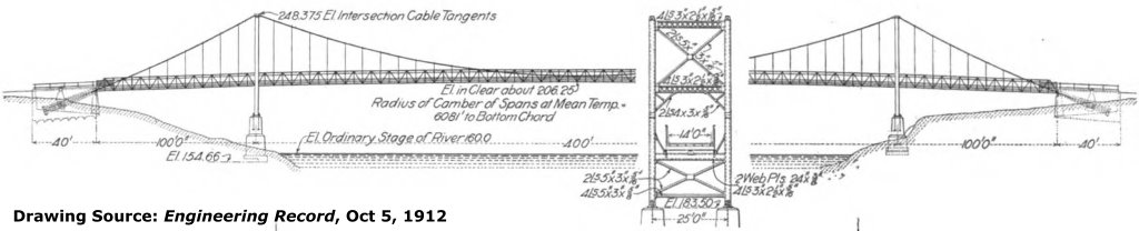
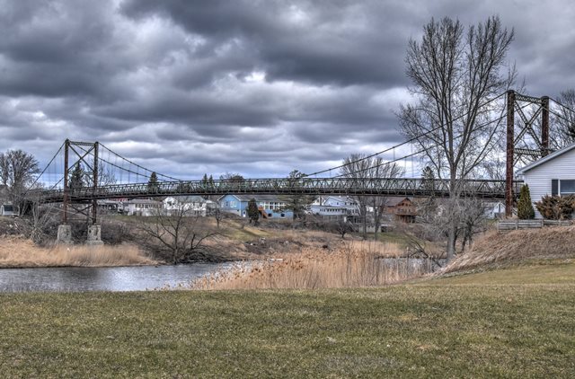
This bridge is a rare example of a small-scale application of a suspension bridge. It is closed to all traffic and abandoned, with a deteriorating deck. Otherwise however the bridge retains good historic integrity with no major alterations. A notable structure when it was built, it received coverage in engineering periodicals of the time. The bridge was designed by Holton D. Robinson, who was involved in the engineering for the Williamsburg Bridge in New York City. Later, he joined famous engineer David Steinman, forming the firm Robinson and Steinman, which went on to design many of the greatest suspension bridges in the country. Perhaps not a coincidence, Robinson was born in nearby Massena. One might wonder, perhaps it is because of his association with Massena that Robinson was chosen to design this bridge, and perhaps it is because of Robinson that a suspension type bridge was selected, when a river of this size would often be spanned with other bridge types like a metal truss bridge. However, there was another more tangible benefit that likely played a big role: The $41,990 cost to build this bridge was $18,000 less than estimates that the town received for other bridge types such as the metal truss bridge.
There was no on-site contracting company who built the bridge; local labor of 20 men was used. John A. Roebling Sons Company provided the cables, and Eastern Steel Company provided the steel for towers, trusses, etc.
![]()
![]()
![]()
Coordinates (Latitude, Longitude):
Search For Additional Bridge Listings:
Bridgehunter.com: View listed bridges within 0.5 miles (0.8 kilometers) of this bridge.
Bridgehunter.com: View listed bridges within 10 miles (16 kilometers) of this bridge.
Additional Maps:
Google Streetview (If Available)
GeoHack (Additional Links and Coordinates)
Apple Maps (Via DuckDuckGo Search)
Apple Maps (Apple devices only)
Android: Open Location In Your Map or GPS App
Flickr Gallery (Find Nearby Photos)
Wikimedia Commons (Find Nearby Photos)
Directions Via Sygic For Android
Directions Via Sygic For iOS and Android Dolphin Browser
USGS National Map (United States Only)
Historical USGS Topo Maps (United States Only)
Historic Aerials (United States Only)
CalTopo Maps (United States Only)

© Copyright 2003-2024, HistoricBridges.org. All Rights Reserved. Disclaimer: HistoricBridges.org is a volunteer group of private citizens. HistoricBridges.org is NOT a government agency, does not represent or work with any governmental agencies, nor is it in any way associated with any government agency or any non-profit organization. While we strive for accuracy in our factual content, HistoricBridges.org offers no guarantee of accuracy. Information is provided "as is" without warranty of any kind, either expressed or implied. Information could include technical inaccuracies or errors of omission. Opinions and commentary are the opinions of the respective HistoricBridges.org member who made them and do not necessarily represent the views of anyone else, including any outside photographers whose images may appear on the page in which the commentary appears. HistoricBridges.org does not bear any responsibility for any consequences resulting from the use of this or any other HistoricBridges.org information. Owners and users of bridges have the responsibility of correctly following all applicable laws, rules, and regulations, regardless of any HistoricBridges.org information.
![]()