

View Information About HSR Ratings
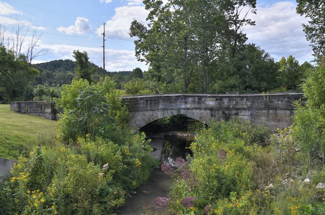
This small "S" stone arch bridge has been bypassed and preserved in place for pedestrian use. Span length is a rough estimate.
Information and Findings From Ohio's Historic Bridge InventorySetting/Context The stone arch bridge on the old National Road has been bypassed since the 1920s. It no longer carries traffic. Physical Description The stone arch bridge has an S-plan to its approach roadways and wingwalls. The arch has coursed ashlar arch barrel, spandrel walls, string course, and parapets. The arch ring has voussoirs and keystone. Summary of Significance The ca. 1828 stone arch bridge is a complete and handsome example of its type/design, typical of the original National Road arches. It is significant both for its technology and historic association with the National Road. The bridge was damaged as a result of flooding in 2005 and partially collapsed. It was rehabilitated as a FEMA project with no adverse effect to the Secretary of the Interiors Standards. The eligible recommendation of the prior assessment remains appropriate. Justification A well represented bridge type throughout the state for both bridges and culverts, stone arch bridges date from the mid 1830s and the building of the National Road through Belmont Co. Many are superbly proportioned and constructed by local contractors. They were used through World War I, particularly during the later years in park settings. More than 125 examples remain. This example has high significance based on its date of construction, detailing, and historic contexts) with the National Road. Bridge Considered Historic By Survey: Yes |
![]()
![]()
![]()
Coordinates (Latitude, Longitude):
Search For Additional Bridge Listings:
Bridgehunter.com: View listed bridges within 0.5 miles (0.8 kilometers) of this bridge.
Bridgehunter.com: View listed bridges within 10 miles (16 kilometers) of this bridge.
Additional Maps:
Google Streetview (If Available)
GeoHack (Additional Links and Coordinates)
Apple Maps (Via DuckDuckGo Search)
Apple Maps (Apple devices only)
Android: Open Location In Your Map or GPS App
Flickr Gallery (Find Nearby Photos)
Wikimedia Commons (Find Nearby Photos)
Directions Via Sygic For Android
Directions Via Sygic For iOS and Android Dolphin Browser
USGS National Map (United States Only)
Historical USGS Topo Maps (United States Only)
Historic Aerials (United States Only)
CalTopo Maps (United States Only)

© Copyright 2003-2024, HistoricBridges.org. All Rights Reserved. Disclaimer: HistoricBridges.org is a volunteer group of private citizens. HistoricBridges.org is NOT a government agency, does not represent or work with any governmental agencies, nor is it in any way associated with any government agency or any non-profit organization. While we strive for accuracy in our factual content, HistoricBridges.org offers no guarantee of accuracy. Information is provided "as is" without warranty of any kind, either expressed or implied. Information could include technical inaccuracies or errors of omission. Opinions and commentary are the opinions of the respective HistoricBridges.org member who made them and do not necessarily represent the views of anyone else, including any outside photographers whose images may appear on the page in which the commentary appears. HistoricBridges.org does not bear any responsibility for any consequences resulting from the use of this or any other HistoricBridges.org information. Owners and users of bridges have the responsibility of correctly following all applicable laws, rules, and regulations, regardless of any HistoricBridges.org information.
![]()