HistoricBridges.org Menu: HistoricBridges.org Menu:


We Recommend:
Bach Steel - Experts at historic truss bridge restoration.

HistoricBridges.org: Bridge Browser

Badley Bridge

Metcalfe Street Bridge

Badley Bridge

Primary Photographer(s): Nathan Holth and Rick McOmber

Bridge Documented: July 21, 2012 and September 27, 2015

View Photos
and Videos
View Maps
and Links

Facility Carried / Feature Intersected
Metcalfe Street (CR-21) Over Grand River
Location
Elora: Wellington County, Ontario: Canada
Structure Type
Metal 9 Panel Rivet-Connected Parker Through Truss, Fixed and Approach Spans: Concrete T-Beam, Fixed
Construction Date and Builder / Engineer
1953 By Builder/Contractor: Hamilton Bridge Company of Hamilton, Ontario
Rehabilitation Date
Not Available or Not Applicable
Main Span Length
Not Available
Structure Length
236.0 Feet (71.9 Meters)
Roadway Width
24 Feet (7.32 Meters)
Spans
1 Main Span(s) and 2 Approach Span(s)
Inventory Number
Not Applicable

Historic Significance Rating (HSR)
View Information About HSR Ratings

Bridge Documentation

This bridge no longer exists!

Bridge Status: Demolished and replaced in 2020.

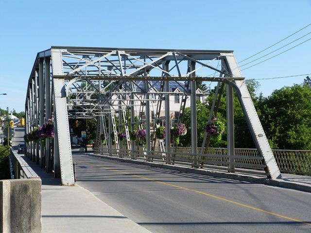
This bridge is not the oldest heritage bridge with a 1952-1953 construction date, however it remains a locally uncommon example of its type and it still retains the eye-catching beauty and design details of earlier metal truss bridges. Unlike a modern bridge which would not even look like a bridge and rather have the appearance of a slab of concrete crossing the water, this bridge's impressive trusses catch the eye and provide a distinctive gateway into or out of downtown Elora. Elora has enhanced the bridge's landmark/gateway image and aesthetics by hanging flower baskets from the truss panels... something that would be far more difficult to do on a modern bridge which would have no trusses. This bridge retains paint on it and appears to be in good condition overall.

Note that a short distance west of this bridge there are stone piers visible. These piers once held an extremely rare multi-span pony truss, however this bridge was demolished.

Despite this bridge's location as a dramatic gateway heritage bridge, it has been demolished.

View Cultural Heritage Report For This Bridge

View Heritage Bridge Inventory Sheet For This Bridge


This bridge is tagged with the following special condition(s): Unorganized Photos

Divider

Photo Galleries and Videos: Badley Bridge


View Photo Gallery

Bridge Photo-Documentation

Original / Full Size Photos
A collection of overview and detail photos. This gallery offers photos in the highest available resolution and file size in a touch-friendly popup viewer.
Alternatively, Browse Without Using Viewer

Divider

View Photo Gallery

Bridge Photo-Documentation

Mobile Optimized Photos
A collection of overview and detail photos. This gallery features data-friendly, fast-loading photos in a touch-friendly popup viewer.
Alternatively, Browse Without Using Viewer

Divider

View Video

Northbound Crossing

Full Motion Video
Streaming video of the bridge. Also includes a higher quality downloadable video for greater clarity or offline viewing.

Divider

View Photo Gallery

Additional Unorganized Photos

Original / Full Size Photos
A supplemental collection of photos that are from additional visit(s) to the bridge and have not been organized or captioned. This gallery offers photos in the highest available resolution and file size in a touch-friendly popup viewer.
Alternatively, Browse Without Using Viewer

Divider

View Photo Gallery

Additional Unorganized Photos

Mobile Optimized Photos
A supplemental collection of photos that are from additional visit(s) to the bridge and have not been organized or captioned. This gallery features data-friendly, fast-loading photos in a touch-friendly popup viewer.
Alternatively, Browse Without Using Viewer

Divider

Maps and Links: Badley Bridge

This historic bridge has been demolished. This map is shown for reference purposes only.

Coordinates (Latitude, Longitude):

Search For Additional Bridge Listings:

HistoricBridges.org Bridge Browser: View listed bridges within 0.5 miles (0.8 kilometers) of this bridge.

HistoricBridges.org Bridge Browser: View listed bridges within 10 miles (16 kilometers) of this bridge.

Additional Maps:

Google Maps

Google Streetview (If Available)

Bing Maps

OpenStreetMap

GeoHack (Additional Links and Coordinates)

Apple Maps (Via DuckDuckGo Search)

Apple Maps (Apple devices only)

MapQuest

HERE We Go Maps

ACME Mapper

Waze Map

Android: Open Location In Your Map or GPS App

Flickr Gallery (Find Nearby Photos)

Wikimedia Commons (Find Nearby Photos)

Directions Via Sygic For Android

Directions Via Sygic For iOS and Android Dolphin Browser


Divider
 
Home Top

Divider

About - Contact

© Copyright 2003-2024, HistoricBridges.org. All Rights Reserved. Disclaimer: HistoricBridges.org is a volunteer group of private citizens. HistoricBridges.org is NOT a government agency, does not represent or work with any governmental agencies, nor is it in any way associated with any government agency or any non-profit organization. While we strive for accuracy in our factual content, HistoricBridges.org offers no guarantee of accuracy. Information is provided "as is" without warranty of any kind, either expressed or implied. Information could include technical inaccuracies or errors of omission. Opinions and commentary are the opinions of the respective HistoricBridges.org member who made them and do not necessarily represent the views of anyone else, including any outside photographers whose images may appear on the page in which the commentary appears. HistoricBridges.org does not bear any responsibility for any consequences resulting from the use of this or any other HistoricBridges.org information. Owners and users of bridges have the responsibility of correctly following all applicable laws, rules, and regulations, regardless of any HistoricBridges.org information.

Admin Login

Divider