

View Information About HSR Ratings
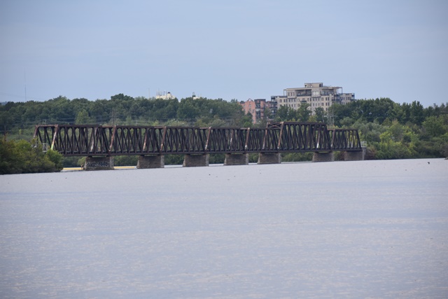
In all reality this is two bridges with Lemieux Island in the middle. Pictured above is the north bridge, and the southern bridge is shown in a photo below. The spans are all about the same size except for one span on the northern bridge which is notably longer although the truss configuration is the same.
History of the previous structure on site is available at this website. Note that the current bridge's piers were reused from this structure. History of the current structure and other rail bridges in the area is at this website.
Given overall bridge length above is the length of the north and south bridges added together, not including the portion of the railway on the island. From Hull to Lemieux Island the north bridge spans a total of 1209' (369m) with 6 piers and 7 trusses. The south bridge between Ottawa and Lemieux Island spans 943.5' (288m) and has 5 piers and 6 trusses. The length of the trusses from Gatineau to Lemieux Island are : 163' 9" (49.9m), 258' 7" (78.8m), 138' 8" (42.3m), 153'9" (46.9m), 153' 7" (46.8m), 153' 7"(46.8m), 153' 8" (46.8m) and the length of the trusses from Lemieux Island to Ottawa are: 6 spans of 153' 9" (46.9m) each.
The bridge has been closed to railway traffic for some time. The bridge has been the source of much discussion and controversy in terms of what the future use of the bridge should be. Most discussions have tended toward a pedestrian usage, but a new rail related use has even been considered. Fortunately the discussions usually focus on reusing the existing heritage bridge so the bridge appears to be safe from demolition for the time being. As of July 2021, a final plan appears to have materialized that will preserve this important heritage bridge for pedestrian use. The bridge has also been renamed to Chief William Commanda Bridge as part of this project.

Above: The southern bridge.

Above: Historical photo from Phoenix Bridge Company catalog showing previous bridge at this location.
![]()
![]()
![]()
Coordinates (Latitude, Longitude):
Search For Additional Bridge Listings:
Additional Maps:
Google Streetview (If Available)
GeoHack (Additional Links and Coordinates)
Apple Maps (Via DuckDuckGo Search)
Apple Maps (Apple devices only)
Android: Open Location In Your Map or GPS App
Flickr Gallery (Find Nearby Photos)
Wikimedia Commons (Find Nearby Photos)
Directions Via Sygic For Android
Directions Via Sygic For iOS and Android Dolphin Browser

© Copyright 2003-2024, HistoricBridges.org. All Rights Reserved. Disclaimer: HistoricBridges.org is a volunteer group of private citizens. HistoricBridges.org is NOT a government agency, does not represent or work with any governmental agencies, nor is it in any way associated with any government agency or any non-profit organization. While we strive for accuracy in our factual content, HistoricBridges.org offers no guarantee of accuracy. Information is provided "as is" without warranty of any kind, either expressed or implied. Information could include technical inaccuracies or errors of omission. Opinions and commentary are the opinions of the respective HistoricBridges.org member who made them and do not necessarily represent the views of anyone else, including any outside photographers whose images may appear on the page in which the commentary appears. HistoricBridges.org does not bear any responsibility for any consequences resulting from the use of this or any other HistoricBridges.org information. Owners and users of bridges have the responsibility of correctly following all applicable laws, rules, and regulations, regardless of any HistoricBridges.org information.
![]()