We Recommend:
Bach Steel - Experts at historic truss bridge restoration.
Queen Street Bridge
Riverside Bridge / Queen Street Viaduct

Primary Photographer(s): Nathan Holth
Bridge Documented: June 20, 2013
Queen Street And TTC Streetcar Over Don River, Don Valley Parkway, Bayview Avenue, and Railroad
Toronto: Toronto City, Ontario: Canada
Metal 7 Panel Rivet-Connected Pratt Through Truss, Fixed and Approach Spans: Metal Deck Girder, Fixed
1911 By Builder/Contractor: Cleveland Bridge and Engineering Company of Darlington, England
2002
129.0 Feet (39.3 Meters)
Not Available
Not Available
1 Main Span(s)
Not Applicable

View Information About HSR Ratings
Bridge Documentation
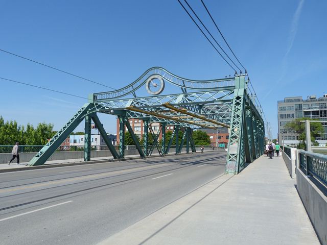
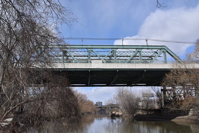
This bridge is significant for several reasons. It is a somewhat complex bridge in its span arrangement. It features a traditionally composed through truss main span over the Don River. West of this span, a series of deck plate girder spans of varying length are present. Moreover, the bridge deck forms a "y" configuration, as two ramps form, one leading down to Queen Street, and the other leading down to King Street. East of the main span, the original two through plate girder approach spans have been replaced, likely to accommodate the Don Valley Parkway.
One of the most unique aspects of this bridge has to do with where the bridge's steel came from. HistoricBridges.org found six different brands on the steel! This means steel from the bridge came from six different steel mills. The mills are of English and Scottish origin. While it is not uncommon to find two or three different brands on a bridge, six is fairly unusual. Not only did the steel of this bridge come from overseas, it appears the bridge was built by a prominent English contractor, Cleveland Bridge and Engineering Company of Darlington, England. That this company built the bridge was determined based on comments in a volume of Sessional Papers for the Legislature of the Province of Ontario.
This bridge remains in good physical condition today. The main through truss span has a non-original public art display mounted on top of the portal bracing.
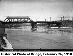
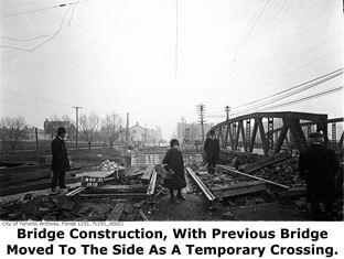
The previous bridge at this location was a rivet-connected Warren pony truss. This design, most common on post-1900 bridges, suggest that this bridge was not in service very long before being replaced by the current bridge. During construction of the present bridge, this previous bridge was slid over to the side, where it served as a temporary bridge, while the present bridge was constructed in the original location of the previous bridge.
![]()
Photo Galleries and Videos: Queen Street Bridge
Bridge Photo-Documentation
Original / Full Size PhotosA collection of overview and detail photos. This gallery offers photos in the highest available resolution and file size in a touch-friendly popup viewer.
Alternatively, Browse Without Using Viewer
![]()
Bridge Photo-Documentation
Mobile Optimized PhotosA collection of overview and detail photos. This gallery features data-friendly, fast-loading photos in a touch-friendly popup viewer.
Alternatively, Browse Without Using Viewer
![]()
Additional Unorganized Photos
Original / Full Size PhotosA supplemental collection of photos that are from additional visit(s) to the bridge and have not been organized or captioned. This gallery offers photos in the highest available resolution and file size in a touch-friendly popup viewer.
Alternatively, Browse Without Using Viewer
![]()
Additional Unorganized Photos
Mobile Optimized PhotosA supplemental collection of photos that are from additional visit(s) to the bridge and have not been organized or captioned. This gallery features data-friendly, fast-loading photos in a touch-friendly popup viewer.
Alternatively, Browse Without Using Viewer
![]()
Maps and Links: Queen Street Bridge
Coordinates (Latitude, Longitude):
Search For Additional Bridge Listings:
Additional Maps:
Google Streetview (If Available)
GeoHack (Additional Links and Coordinates)
Apple Maps (Via DuckDuckGo Search)
Apple Maps (Apple devices only)
Android: Open Location In Your Map or GPS App
Flickr Gallery (Find Nearby Photos)
Wikimedia Commons (Find Nearby Photos)
Directions Via Sygic For Android
Directions Via Sygic For iOS and Android Dolphin Browser


