

View Information About HSR Ratings
The bridge is mentioned in Caledonia: Along the Grand River, a book by Barbara Martindale. The bridge was erected by Melvin Runchey. His services cost $200 to complete construction in two months. The truss superstructure was the product of the prolific Hamilton Bridge Works. The cost of the superstructure was $1000. J. H. Creighton received just under $100 for planking, while Caledonia Milling Company also recieved $114.50 for "cement and lumber." The total cost of the bridge was $1400. The bridge served traffic until 1950 when a new highway alignment was constructed parallel to the bridge immediately to the north. As part of the highway construction, the small Black Creek was realigned so that it passed under the road and entered Grand River a short distance to the west. The construction of the new alignment filled in the old creek bed, nearly to the bridge itself. Today, it is dry under the bridge.
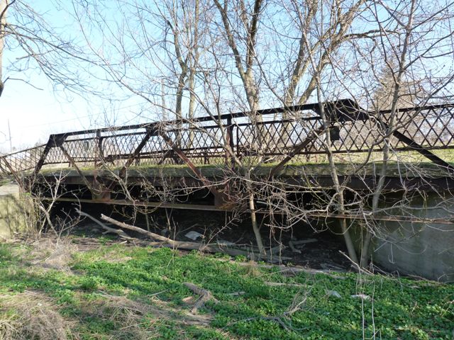
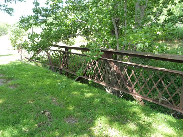
The bridge is a listed heritage structure, since it is locally significant as a product of local contractors and is today a locally rare example of its type. The bridge retains good historic integrity including original railings. The deck appears to be concrete with a wood plank base remaining in place.
Today, the bridge has been abandoned for over half of a century. One of the significant issues that has developed with the bridge is that the north truss is becoming severely bent and distorted. Some of the damage may have been from specific events like a tree possibly falling on the bridge. Additionally, all the dirt piled up to fill in the creek comes very close to the truss at the eastern end. This dirt might be putting pressure on the bridge and its abutments. Also, this area of dirt is now home to what has become a full size tree. This tree appears to be putting pressure on the bridge. Now would be a great time to consider the restoration and preservation of this bridge. Removal of the tree would be a great and easy start. The truss itself could also be restored. It is possible to correct the bending of the steel through methods like heat straightening.
Information and Findings From Canada's Historic PlacesDescription of Historic Place The Seneca Bridge is a small steel and concrete
bridge, crossing the Black Creek on the River Road (Highway 54, between
Caledonia and Cayuga), in Haldimand County. Following the 1912 Good Road
Convention's guidelines, the bridge handled all the road traffic between
the two towns for more than thirty years. Heritage Value The Good Road Convention, at Toronto on May 7, 1912,
recommended that all new bridges from four to forty feet in length be
built with steel beams embedded in concrete for structural stability.
Any bridge over forty feet in length should be built solely of steel.
The Seneca Bridge, built in 1913, and following these recommendations,
has lasted more than 90 years, though it is no longer in use.
Constructed by local contractors, the bridge stands as a testament to
the area's economic development. The Ontario provincial government took
over control of River Road from Cayuga to Caledonia from the Country, in
or before 1937. At that time, it was renamed Highway 54. The Seneca
Bridge handled all traffic between the two towns until 1950, when it was
replaced with a larger structure. The bridge still stands today. Character-Defining Elements Character defining elements that reflect the
heritage value of the Seneca Bridge include its: |
This bridge is tagged with the following special condition(s): Unorganized Photos
![]()
![]()
![]()
![]()
![]()
Coordinates (Latitude, Longitude):
Search For Additional Bridge Listings:
Additional Maps:
Google Streetview (If Available)
GeoHack (Additional Links and Coordinates)
Apple Maps (Via DuckDuckGo Search)
Apple Maps (Apple devices only)
Android: Open Location In Your Map or GPS App
Flickr Gallery (Find Nearby Photos)
Wikimedia Commons (Find Nearby Photos)
Directions Via Sygic For Android
Directions Via Sygic For iOS and Android Dolphin Browser

© Copyright 2003-2024, HistoricBridges.org. All Rights Reserved. Disclaimer: HistoricBridges.org is a volunteer group of private citizens. HistoricBridges.org is NOT a government agency, does not represent or work with any governmental agencies, nor is it in any way associated with any government agency or any non-profit organization. While we strive for accuracy in our factual content, HistoricBridges.org offers no guarantee of accuracy. Information is provided "as is" without warranty of any kind, either expressed or implied. Information could include technical inaccuracies or errors of omission. Opinions and commentary are the opinions of the respective HistoricBridges.org member who made them and do not necessarily represent the views of anyone else, including any outside photographers whose images may appear on the page in which the commentary appears. HistoricBridges.org does not bear any responsibility for any consequences resulting from the use of this or any other HistoricBridges.org information. Owners and users of bridges have the responsibility of correctly following all applicable laws, rules, and regulations, regardless of any HistoricBridges.org information.
![]()