


View Information About HSR Ratings
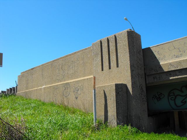
Although not the most beautiful bridge in the world at the time of demolition, this bridge was a noteworthy bridge that although on I-69/I-94, actually pre-dates the Interstate Highway System, and has some technologically significant details. This bridge was built in 1950, and was originally part of M-146, a short trunkline road that was long ago decommissioned. M-146 was a short route that ran from 24th Street, to Lapeer Avenue, then to what is today M-25. When built, this bridge would have looked a lot more beautiful, because it had Michigan's signature type R4 railings like those seen on Sigler Road. These attractive railings would have complimented the modest architectural detailing on the piers and abutments of this bridge. The architectural details of the piers and abutments managed to survive on the bridge, but the R4 railings were replaced with New Jersey barriers, which greatly diminished the aesthetic value of the bridge.
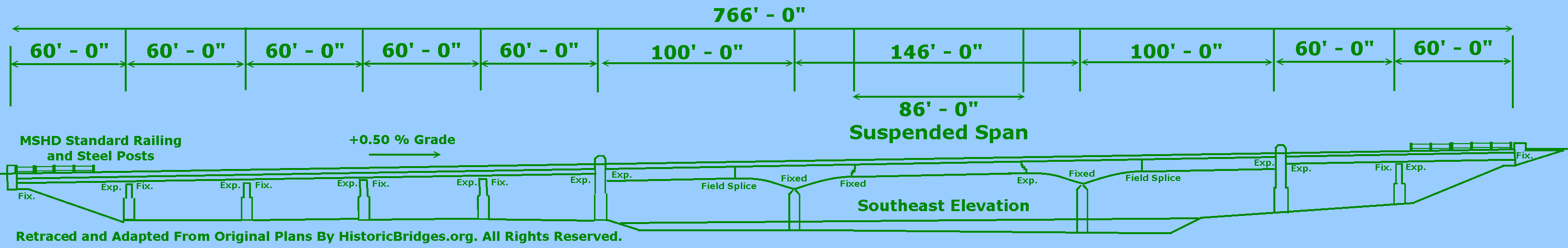
Structurally, the bridge consists of three deck plate girder spans and seven steel stringer spans. The bridge was technologically significant for its uncommon cantilevered deck plate girder design which includes an 86 foot suspended span which is connected to the bridge by a pin and hanger type system. The Michigan State Highway department built a number of cantilevered deck plate girders across the state, and a number of them remain today. Not all of them have the pin and hanger detail however. The anchor arm main spans on either side of the cantilever span include a field splice connection where the built-up plate girders were attached during erection. Also, the bridge was designed so that the main spans of the bridge function at two separate parallel bridges sharing a single pier. There are two pairs of deck plate girders under the bridge, each with their own set of floorbeams. At certain locations under the bridge a tiny gap in the deck is visible demonstrating this two bridge design. Finally, adding to the complexity of this bridge was the seven approach spans which turn the bridge into a relatively long (for Michigan) bridge of 766 feet. Also, the bridge had an 18 degree skew.
Unfortunately, this bridge ended up being sentenced to the dumpster. As a 1950 bridge that was not designed with the Interstate Highway System in mind, the bridge was very narrow and a serious bottleneck for expressway traffic, lacking an acceleration lane for the Water Street ramp, and also lacking sufficient shoulders. Structurally however, the bridge was still in decent condition. The steel superstructure appeared to be in very good condition, with the only areas of significant rust and deterioration being around expansion joints. The abutments and piers had some areas of spalling, but nothing severe that could not be corrected by rehabilitation. The deck was the only part of the bridge in extremely bad condition. One could not complain too much about the deck however, since it appeared to be the original 1950 deck, which is impressive given the massive volume of heavy truck traffic this bridge has carried as an I-69/I-94 bridge. The replacement of this bridge was part of a larger project to completely reconstruct I-69/I-94 in the immediate area, and this greater project was designed to compliment a planned expansion of the toll and customs plaza for the Blue Water Bridge.
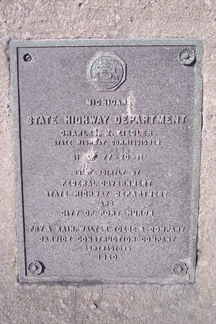
As the ad shown below indicated, steel for this bridge was fabricated locally under subcontract by F. Yeager Bridge and Culvert Company of Port Huron.


This bridge is tagged with the following special condition(s): Unorganized Photos
![]()
![]()
![]()
![]()
![]()
![]()
![]()
This historic bridge has been demolished. This map is shown for reference purposes only.
Coordinates (Latitude, Longitude):
Search For Additional Bridge Listings:
Bridgehunter.com: View listed bridges within 0.5 miles (0.8 kilometers) of this bridge.
Bridgehunter.com: View listed bridges within 10 miles (16 kilometers) of this bridge.
Additional Maps:
Google Streetview (If Available)
GeoHack (Additional Links and Coordinates)
Apple Maps (Via DuckDuckGo Search)
Apple Maps (Apple devices only)
Android: Open Location In Your Map or GPS App
Flickr Gallery (Find Nearby Photos)
Wikimedia Commons (Find Nearby Photos)
Directions Via Sygic For Android
Directions Via Sygic For iOS and Android Dolphin Browser
USGS National Map (United States Only)
Historical USGS Topo Maps (United States Only)
Historic Aerials (United States Only)
CalTopo Maps (United States Only)

© Copyright 2003-2024, HistoricBridges.org. All Rights Reserved. Disclaimer: HistoricBridges.org is a volunteer group of private citizens. HistoricBridges.org is NOT a government agency, does not represent or work with any governmental agencies, nor is it in any way associated with any government agency or any non-profit organization. While we strive for accuracy in our factual content, HistoricBridges.org offers no guarantee of accuracy. Information is provided "as is" without warranty of any kind, either expressed or implied. Information could include technical inaccuracies or errors of omission. Opinions and commentary are the opinions of the respective HistoricBridges.org member who made them and do not necessarily represent the views of anyone else, including any outside photographers whose images may appear on the page in which the commentary appears. HistoricBridges.org does not bear any responsibility for any consequences resulting from the use of this or any other HistoricBridges.org information. Owners and users of bridges have the responsibility of correctly following all applicable laws, rules, and regulations, regardless of any HistoricBridges.org information.
![]()