


View Information About HSR Ratings

At the time of demolition, the historic Military Street Bridge was the oldest bascule bridge in Michigan and it was also noted for its gorgeous ornate railings. These railings are what HistoricBridges.org describes as "arched lattice railing". These railings follow a general pattern of arched lattice on the top of each panel, with a row of traditional lattice in a smaller lower section of the panel. The exact design varies from bridge to bridge and the railings were not a product of a particular bridge company, and they appear on a vast variety of bridges from the late 19th century into the early part of the 20th Century. That said, railings of this style are also very rare today. The historic Military Street Bridge also featured wooden walkways on each side, a feature once seen on all three of the Port Huron bascule bridges, but now present on none of Port Huron's bridges.
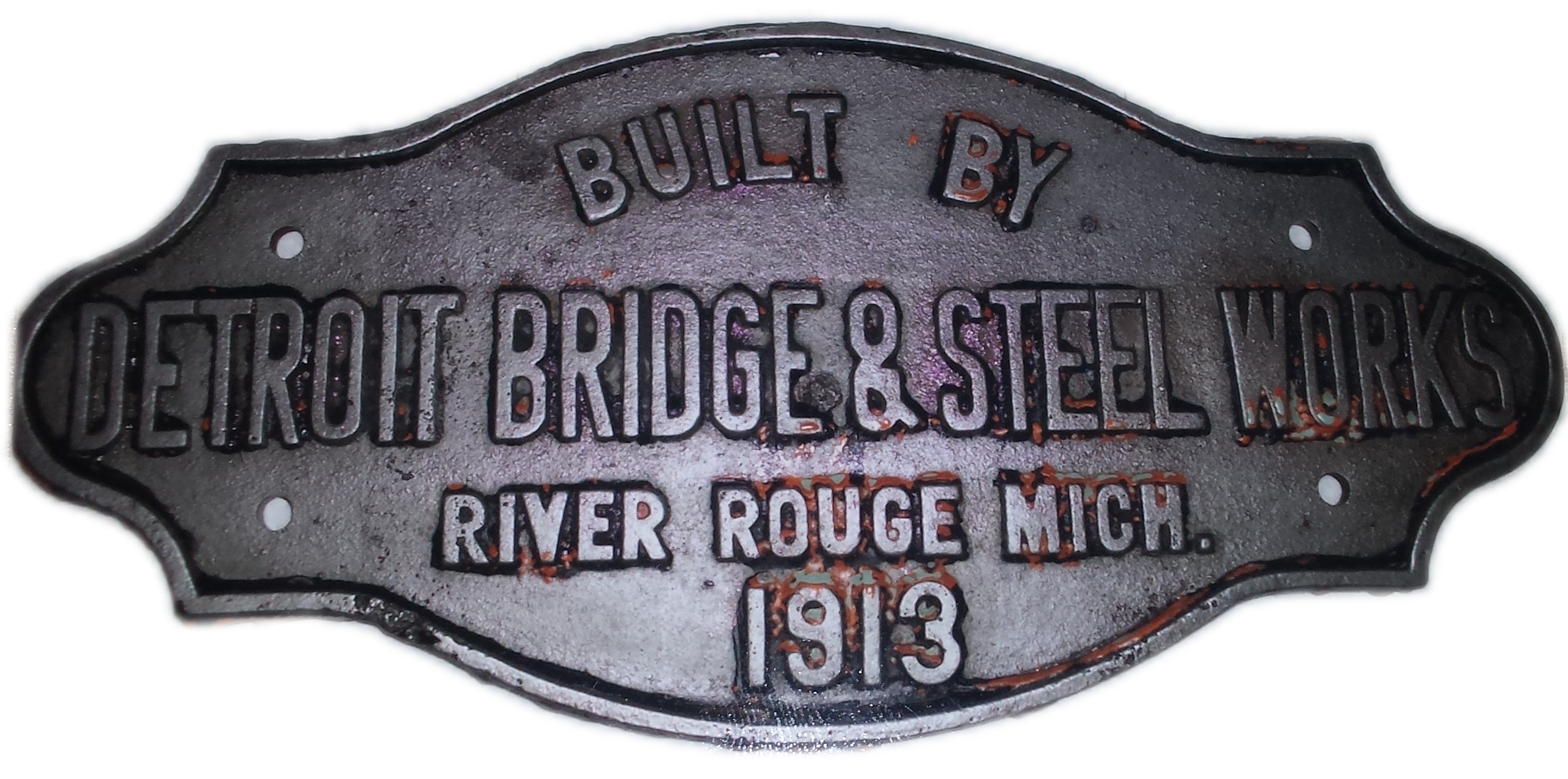
In 1990, a replacement project demolished this historic bridge. A disgrace to the Section 106 process, mitigation for the adverse affect of demolishing this bridge did not include the storage and/or preservation of even a single panel of the elegant railings, which would have been an obvious form of mitigation. Unfortunately, the historic Military Street Bridge was demolished before HistoricBridges.org existed, and as such, HAER is the main source for photos of this bridge. Additionally, James Colo, who was project manager for the replacement of the bridge discovered the original builder plaque hidden under layers of paint on one of the bridge girders and saved it from being scrapped. A photo of the plaque is shown on this page.

The Military bridge is the latest in a long history of spans at this location. According to Robert L. Davis, the earliest known bridge at this location was built in 1833 and is the one that completed the Military Rd. also known as the Fort Gratiot Turnpike. The 1833 bridge survived until 1854, when a schooner captain deliberately destroyed it. Captain Stockman, operating a schooner owned by the Black River Steam Saw Mill, approached the bridge on a Sunday and signaled for the bridge to open. The two movable wings became locked together and Alanson Shelley, manager of the sawmill, ordered the captain to remove the bridge as an "obstruction to navigation" and sent carpenters from the sawmill to do the work. The county highway commission tried to sue for the loss of the bridge, but lost the case in the courts. The wooden bridge was 22 feet wide and 240 feet long, with approaches and had a 40 foot draw span consisting of two 20-foot leaves raised by windlass.
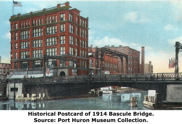
The next span at this location was a wooden swing bridge dating to around the 1850s. The next span was a beautiful pin-connected metal through truss swing bridge which appears to have been built by the Smith Bridge Company of Toledo, Ohio based on the design of the portal bracing, plaque, and finials. Spans by this company of this style typically date to the 1880s. The through span gave Port Huron a beautiful gateway into the city. The next span was the 1914 two leaf bascule bridge with the ornate railings. It also had attractive overhead "trolley arches" to hold the electric lines for the trolleys. These arches were removed in the 1950s. This bridge was the one the current 1991 span replaced.
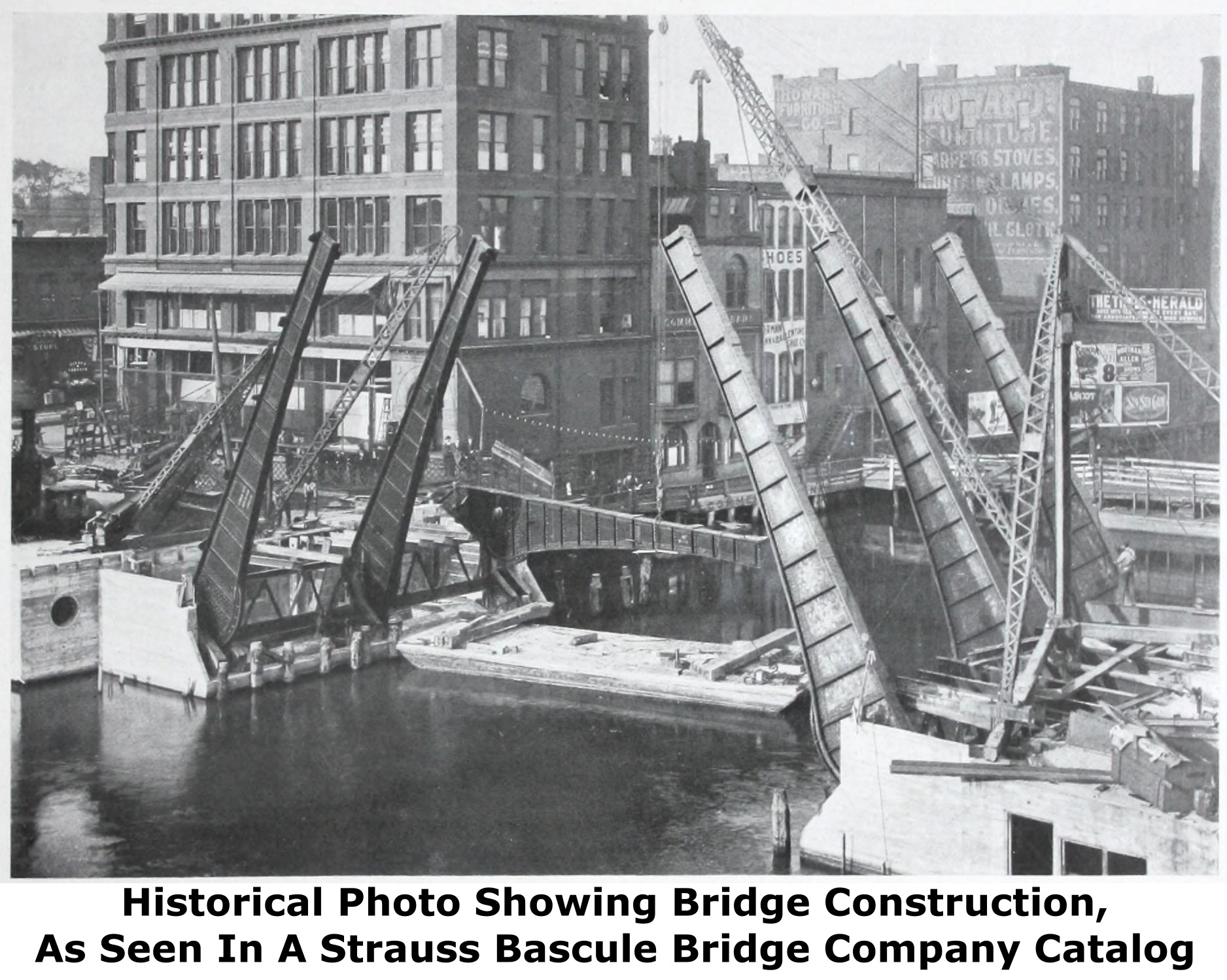
The 1914 bascule bridge was highly significant both historically and technologically. It was the oldest highway bascule bridge in Michigan at the time of demolition. It also was a rare example of a Strauss trunnion bascule bridge. Designed by famous engineer Joseph Strauss, the design included a main trunnion as well as a counterweight trunnion. Many Strauss bascule bridge designs put the counterweight over the roadway, but this more aesthetically pleasing design concealed the counterweight below the deck. Designed in 1912, this bridge was among the earliest surviving examples of a bridge designed by Joseph Strauss.

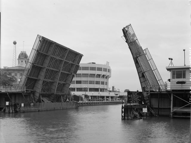
When the current span was built, MDOT was responsible for the monetary responsibilities, since the bridge was located on an Interstate Business Loop. All the latest in technology was used to build this highly computerized and hydraulics powered bridge. All of this fancy stuff was supposed to make the bridge better than the old bridge. However, the new bridge has caused problems ever since the bridge was put into service. Sometimes when it got hot in the summer, they would have fireman come and hose the bridge down to keep it cool enough to operate (by causing the metal to shrink)! Leading up to 2014, even though the bridge was only a few decades old, the bridge's poor construction quality already showed up in bridge inspection findings. In the National Bridge Inventory, the bridge's superstructure dropped down to "Fair" which is 5/10. This is a very rapid decline in superstructure condition. The bridge was apparently also not designed to provide for the traffic needs of the area, and the bridge has already been classified as functionally obsolete. The bridge's sufficiency was prior to rehabilitation only 54.6%, again extremely low for a bridge this young. Requests can often be made for total replacement funds when a bridge's sufficiency drops below 50%.

It should also be noted that even under normal operation, the bridge raises and lowers more slowly than most historic double-leaf bascule bridges that still operate under traditional electric motor. A good example would be in Chicago where bridges on the busy Calumet River can be raised in as little as 40 seconds. This bridge in Port Huron definitely cannot raise that quickly. This is partially due to the bridge's rolling lift design which cannot raise as quickly, whereas the previous bridge and the bridges in Chicago are fixed trunnion design. The rolling lift type was chosen for the replacement bridge to meet the clearance requirements for the location. When a rolling lift bascule is raised, it rolls back on a track which has the side effect of moving the leaves further back away from the river, thus increasing space for navigation. Thus, the rolling lift design met the needs for navigation, while reducing the footprint of the bridge which had to be fit in a very limited space right in the heart of downtown Port Huron.
So what of the 2014-2015 rehabilitation? If you think that fixed the bridge's problems think again. After rehabilitation (which included a complete overhaul of the ever-troublesome hydraulic operating equipment) the bridge reopened to traffic in March of 2015. However, apparently a few details were overlooked. The bridge closed in April for replacement of a hydraulic hose. The bridge closed again in July 2015 expectedly when there was "an issue with the hydraulic system" according to MDOT. It turned out the hydraulic motor had failed and needed to be replaced. As of this writing in July 2015, MDOT already is planning yet another closure to (big surprise) "replace hydraulic hoses."
Given the constant problems this bridge has had, a few questions arise. Why didn't MDOT just rehabilitate the historic bridge designed by a world renowned engineer? Why didn't MDOT stick with the tried and true, reliable method of operating a bascule bridge using a simple electric motor connected to a series of gears? This system is what keeps Chicago's many historic bridges raising quicker and more reliably even today after decades of use. And the final question, what has this world come to when all of today's engineers and computers cannot design something that works as reliably as a bridge designed by hand in the early 20th century? They sure don't build them like they used to!
HistoricBridges.org did arrange a tour of the current Military Street Bridge, which, like any movable bridge is a lot more than just a span over a river and has a lot of mechanical equipment that is not out in the open for anyone to see. These photos are presented for comparison to the operation of historic bascule bridges such as the Seventh Street Bridge. The equipment and controls that operate a modern bascule are vastly different from historic bascule bridges.

Above: According to Robert L. Davis, this was the second bridge at this location and the earliest bridge there is a known photo of.
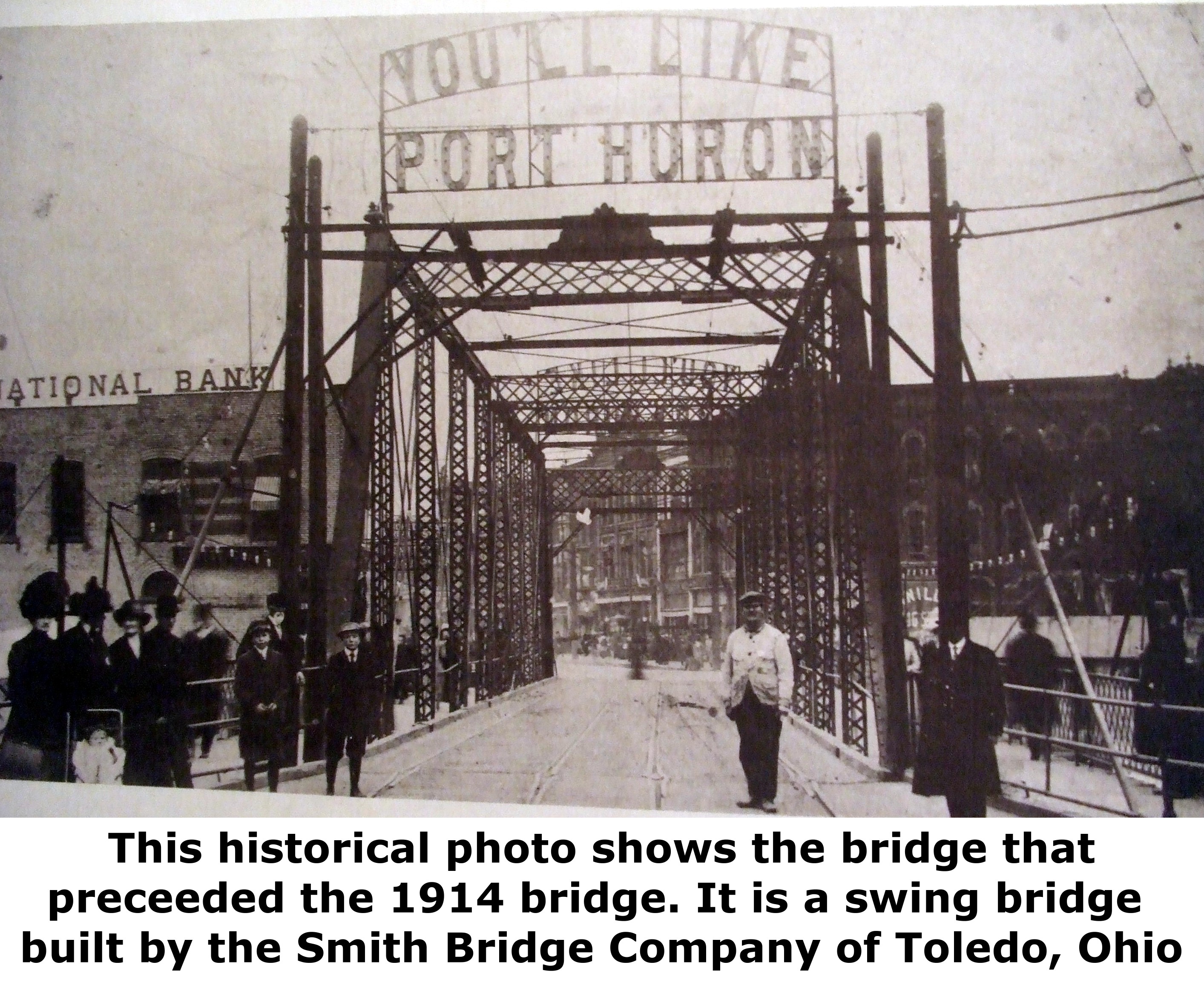
Above: The third known bridge at this location, a pin-connected through truss swing bridge. Likely a ca. 1880s bridge built by the Smith Bridge Company of Toledo, Ohio.

Above: Another photo showing the third known bridge at this location. While this photo might appear to show the bridge under construction, it actually is documenting the installation of an underground/underwater pipeline next to the bridge. The project was documented in a news article from 1899, so it is assumed the photo dates to around that period. The pipe installation was challenging because the swing bridge opened up over where the work was taking place, and due to the navigable nature of the river, one half of the channel had to be kept open at all times.
Above: The fourth known bridge at this location.
This bridge is tagged with the following special condition(s): Arch Lattice Railing
![]()
![]()

![]()
![]()
![]()

![]()
![]()
This historic bridge has been demolished. This map is shown for reference purposes only.
Coordinates (Latitude, Longitude):
Search For Additional Bridge Listings:
Bridgehunter.com: View listed bridges within 0.5 miles (0.8 kilometers) of this bridge.
Bridgehunter.com: View listed bridges within 10 miles (16 kilometers) of this bridge.
Additional Maps:
Google Streetview (If Available)
GeoHack (Additional Links and Coordinates)
Apple Maps (Via DuckDuckGo Search)
Apple Maps (Apple devices only)
Android: Open Location In Your Map or GPS App
Flickr Gallery (Find Nearby Photos)
Wikimedia Commons (Find Nearby Photos)
Directions Via Sygic For Android
Directions Via Sygic For iOS and Android Dolphin Browser
USGS National Map (United States Only)
Historical USGS Topo Maps (United States Only)
Historic Aerials (United States Only)
CalTopo Maps (United States Only)

© Copyright 2003-2024, HistoricBridges.org. All Rights Reserved. Disclaimer: HistoricBridges.org is a volunteer group of private citizens. HistoricBridges.org is NOT a government agency, does not represent or work with any governmental agencies, nor is it in any way associated with any government agency or any non-profit organization. While we strive for accuracy in our factual content, HistoricBridges.org offers no guarantee of accuracy. Information is provided "as is" without warranty of any kind, either expressed or implied. Information could include technical inaccuracies or errors of omission. Opinions and commentary are the opinions of the respective HistoricBridges.org member who made them and do not necessarily represent the views of anyone else, including any outside photographers whose images may appear on the page in which the commentary appears. HistoricBridges.org does not bear any responsibility for any consequences resulting from the use of this or any other HistoricBridges.org information. Owners and users of bridges have the responsibility of correctly following all applicable laws, rules, and regulations, regardless of any HistoricBridges.org information.
![]()