

View Information About HSR Ratings
This bridge carries Romeo Plank Road on its current alignment over the river. Before this bridge was built, Romeo Plank crossed the river a short distance west over a concrete arch bridge. This concrete arch bridge remains abandoned in place. Click here to view the page for the arch bridge.
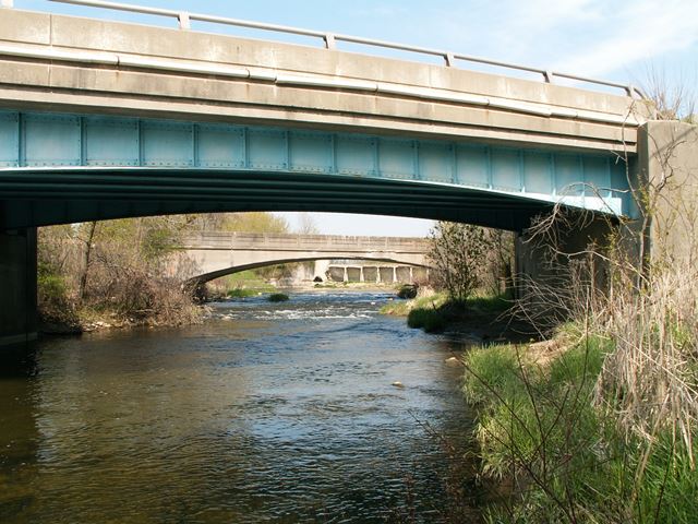
This is a very unusual bridge. Structurally it functions as a steel stringer (ie multi-beam) bridge. With the exception of the fascia beams the stringers are traditional rolled i-beams with diaphragms that are also rolled beams. The fascia beams are what are most unusual. Deeper than the other stringers, they are riveted, built-up beams that have an arch shape to them. The riveted design makes the bridge look older than it is, but the reason the beam was riveted is because the unusual shape could not be rolled, but for a bridge of this age one might have expected the beam to be welded or bolted, not riveted. The only apparent reason for having the arched fascia beam would be for aesthetic reasons. This leads to a question... in the 1960s... an era where aesthetics had mostly been eliminated from bridge design, why would this arched design be used? Another mystery is what the original railings looked like. The railings on the bridge today are not original, but one cannot help but wonder if the bridge was designed to look nice, perhaps some interesting non-standard railing was also used? It is unclear.
![]()
![]()
![]()
This historic bridge has been demolished. This map is shown for reference purposes only.
Coordinates (Latitude, Longitude):
Search For Additional Bridge Listings:
Bridgehunter.com: View listed bridges within 0.5 miles (0.8 kilometers) of this bridge.
Bridgehunter.com: View listed bridges within 10 miles (16 kilometers) of this bridge.
Additional Maps:
Google Streetview (If Available)
GeoHack (Additional Links and Coordinates)
Apple Maps (Via DuckDuckGo Search)
Apple Maps (Apple devices only)
Android: Open Location In Your Map or GPS App
Flickr Gallery (Find Nearby Photos)
Wikimedia Commons (Find Nearby Photos)
Directions Via Sygic For Android
Directions Via Sygic For iOS and Android Dolphin Browser
USGS National Map (United States Only)
Historical USGS Topo Maps (United States Only)
Historic Aerials (United States Only)
CalTopo Maps (United States Only)

© Copyright 2003-2024, HistoricBridges.org. All Rights Reserved. Disclaimer: HistoricBridges.org is a volunteer group of private citizens. HistoricBridges.org is NOT a government agency, does not represent or work with any governmental agencies, nor is it in any way associated with any government agency or any non-profit organization. While we strive for accuracy in our factual content, HistoricBridges.org offers no guarantee of accuracy. Information is provided "as is" without warranty of any kind, either expressed or implied. Information could include technical inaccuracies or errors of omission. Opinions and commentary are the opinions of the respective HistoricBridges.org member who made them and do not necessarily represent the views of anyone else, including any outside photographers whose images may appear on the page in which the commentary appears. HistoricBridges.org does not bear any responsibility for any consequences resulting from the use of this or any other HistoricBridges.org information. Owners and users of bridges have the responsibility of correctly following all applicable laws, rules, and regulations, regardless of any HistoricBridges.org information.
![]()