

View Information About HSR Ratings
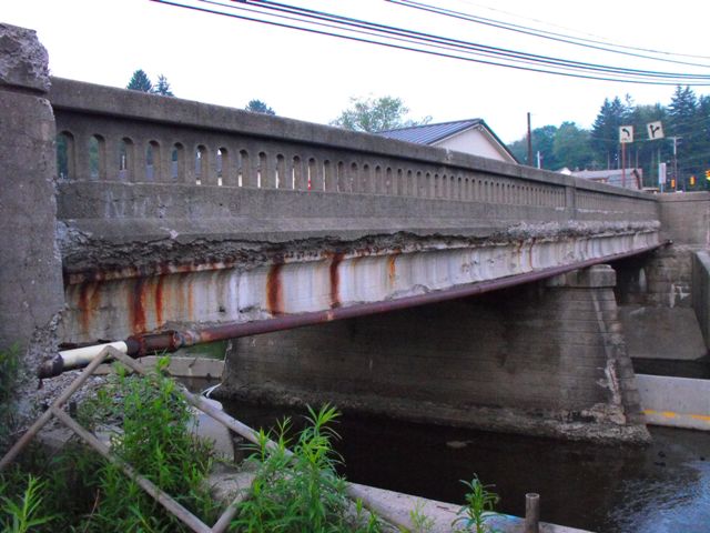
This bridge was an attractive example of a concrete encased steel stringer bridge. The Pennsylvania Historic Bridge Inventory's comments below are a bit misleading. While steel stringers are indeed one of the most common 20th Century bridge types, those stringers which are concrete encased are not as common. As bridges with heritage value go, they may not be overly remarkable or significant, but they are not common, particularly examples with good historic integrity such as this one. This bridge retained unaltered railings, as well as a large bronze plaque.
The bridge was interesting and caught the eye because although the railings were unaltered and original, one side had a different design than the other. The reason for this is because a different railing type was designated for sidewalks than was designated for bridges with no sidewalk. In the case of this bridge, one side had a sidewalk and the other did not. Therefore, the vehicular style railing was used on one side and the sidewalk style railing was used on the other side. The vehicular style railing was a concrete barrier with pierced openings that provide a balustrade design. The design was similar to a common railing type found in Pennsylvania on many t-beams and stringers, although on this bridge the design was more massive in construction than the traditional form. The sidewalk style railing was a solid concrete barrier with inset rectangles composing the architectural detailing.
PennDOT decided to demolish this bridge and replace it with a modern bridge. While this bridge may not have been the most historic bridge, it was an attractive structure, and the replacement will be ugly and will have no heritage value whatsoever. The aesthetic quality of the area will suffer as a result. It is also important to note that over the course of its life, this bridge never received a major rehabilitation, according to the National Bridge Inventory. All bridges should receive a major rehabilitation at least twice over their service life. How much service life was lost from this bridge because it was never rehabilitated? Bridges such as this demonstrate the need for older bridges to be maintained and rehabilitated. This would not only be more fiscally responsible, it would retain these older bridges, which even if not officially "historic" are nevertheless far more beautiful and with more heritage than any modern bridge.
Information and Findings From Pennsylvania's Historic Bridge InventoryDiscussion of Bridge The 1926, 2 simple span, 110'-long encased steel stringer bridge with concrete balustrades is supported on a substructure of ashlar abutments that may date from an earlier bridge and a coursed concrete cutwater pier with toe wall. The substructure has been shored with concrete due to scour. Parapets and balustrades show heavy cracking and other weather damage. Concrete encasement was favored in the state because it provided protection for the steel and eliminated the need to periodically paint the beams. A 2 span, representative example of one of the most common 20th century bridge types and designs in the state, it has no innovative or distinguishing details. It is one of 639. Discussion of Surrounding Area The bridge carries a 2 lane street over a stream in a mixed use commercial and residential area of Brookville. The bridge is outside of the National Register listed Brookville Historic District, and the area surrounding the bridge lacks the fabric of a potential historic district. Bridge Considered Historic By Survey: No |
![]()
![]()
![]()
This historic bridge has been demolished. This map is shown for reference purposes only.
Coordinates (Latitude, Longitude):
Search For Additional Bridge Listings:
Bridgehunter.com: View listed bridges within 0.5 miles (0.8 kilometers) of this bridge.
Bridgehunter.com: View listed bridges within 10 miles (16 kilometers) of this bridge.
Additional Maps:
Google Streetview (If Available)
GeoHack (Additional Links and Coordinates)
Apple Maps (Via DuckDuckGo Search)
Apple Maps (Apple devices only)
Android: Open Location In Your Map or GPS App
Flickr Gallery (Find Nearby Photos)
Wikimedia Commons (Find Nearby Photos)
Directions Via Sygic For Android
Directions Via Sygic For iOS and Android Dolphin Browser
USGS National Map (United States Only)
Historical USGS Topo Maps (United States Only)
Historic Aerials (United States Only)
CalTopo Maps (United States Only)

© Copyright 2003-2024, HistoricBridges.org. All Rights Reserved. Disclaimer: HistoricBridges.org is a volunteer group of private citizens. HistoricBridges.org is NOT a government agency, does not represent or work with any governmental agencies, nor is it in any way associated with any government agency or any non-profit organization. While we strive for accuracy in our factual content, HistoricBridges.org offers no guarantee of accuracy. Information is provided "as is" without warranty of any kind, either expressed or implied. Information could include technical inaccuracies or errors of omission. Opinions and commentary are the opinions of the respective HistoricBridges.org member who made them and do not necessarily represent the views of anyone else, including any outside photographers whose images may appear on the page in which the commentary appears. HistoricBridges.org does not bear any responsibility for any consequences resulting from the use of this or any other HistoricBridges.org information. Owners and users of bridges have the responsibility of correctly following all applicable laws, rules, and regulations, regardless of any HistoricBridges.org information.
![]()