

View Information About HSR Ratings
This rural road is totally undeveloped to the west of this bridge, so much so that the road has fords instead of bridges to the west. Despite this, the road is a state-owned highway, which is perhaps the most distinct evidence that Pennsylvania has a much different road ownership system than most other states. Usually state-owned highways are only major roadways, but Pennsylvania does not operate like this. This creates a problem in Pennsylvania, because PennDOT has one of the worst track records for historic bridge preservation in the country, and unfortunately thanks to the Commonwealth's large number of state-owned roads which include rural roads, this means PennDOT owns a lot of historic bridges because rural roads tend to be where the most old bridges are.
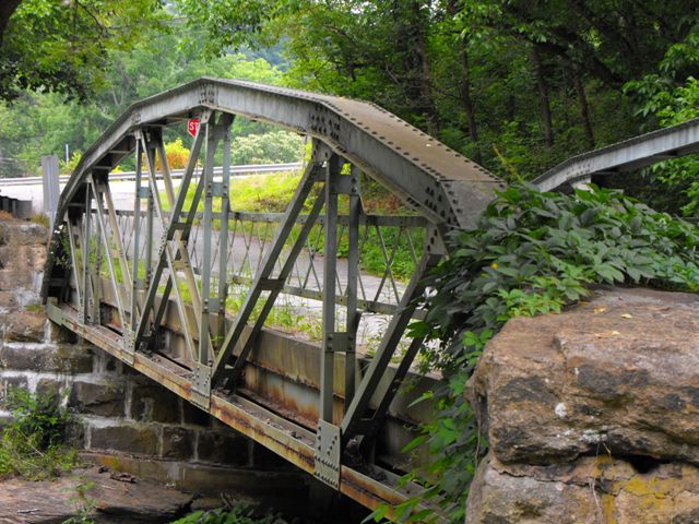
This bridge is a highly attractive The bridge is similar to the Shorb Mill Road Bridge in Adams County, which was built by Nelson and Buchanan, so Chartiers Bridge might be built by them as well. However note that the Shorb Mill Road Bridge uses a different truss configuration, so this association is not for certain.
This is a post-1900 riveted truss bridge. The Pennsylvania Historic Bridge Inventory dismissed the vast majority of post-1900 riveted truss bridges as not historic and not eligible for the National Register of Historic Places, regardless of integrity, size, or construction date. The Pennsylvania historic bridge inventory operates on the philosophy that historic significant arises only from innovative, prototypical engineering, and that significance does not arise from good representative examples of structures from a period in history. This appears to go against the philosophy of the National Register of Historic Places which has accepted structures from both categories in other states. The information below from the Historic Bridge Inventory is provided for structure information and reference only. HistoricBridges.org does not agree with the findings of the below historic bridge inventory assessment.
Information and Findings From Pennsylvania's Historic Bridge InventoryDiscussion of Bridge The 1913, skewed, riveted Parker pony truss bridge is supported on ashlar abutments with wingwalls. All truss members are composed of built up members, and the details reflect the standardization of design that characterizes rivet-connected metal truss bridges. The original lattice railings are inside the truss lines, and the deck is concrete. The bridge has no innovative or distinctive details, and the use of the Parker design for a 68' long span is not noteworthy. In a county with over 30 metal truss bridges dating from 1891 through 1943, and a region with hundreds of examples, the bridge is not historically or technologically significant. Discussion of Surrounding Area The bridge carries a 1 lane road over a stream in a sparsely developed, forested setting with scattered mid and late 20th century residences north of Chartiers. Bridge Considered Historic By Survey: No |
![]()
![]()
![]()
This historic bridge has been demolished. This map is shown for reference purposes only.
Coordinates (Latitude, Longitude):
Search For Additional Bridge Listings:
Bridgehunter.com: View listed bridges within 0.5 miles (0.8 kilometers) of this bridge.
Bridgehunter.com: View listed bridges within 10 miles (16 kilometers) of this bridge.
Additional Maps:
Google Streetview (If Available)
GeoHack (Additional Links and Coordinates)
Apple Maps (Via DuckDuckGo Search)
Apple Maps (Apple devices only)
Android: Open Location In Your Map or GPS App
Flickr Gallery (Find Nearby Photos)
Wikimedia Commons (Find Nearby Photos)
Directions Via Sygic For Android
Directions Via Sygic For iOS and Android Dolphin Browser
USGS National Map (United States Only)
Historical USGS Topo Maps (United States Only)
Historic Aerials (United States Only)
CalTopo Maps (United States Only)

© Copyright 2003-2024, HistoricBridges.org. All Rights Reserved. Disclaimer: HistoricBridges.org is a volunteer group of private citizens. HistoricBridges.org is NOT a government agency, does not represent or work with any governmental agencies, nor is it in any way associated with any government agency or any non-profit organization. While we strive for accuracy in our factual content, HistoricBridges.org offers no guarantee of accuracy. Information is provided "as is" without warranty of any kind, either expressed or implied. Information could include technical inaccuracies or errors of omission. Opinions and commentary are the opinions of the respective HistoricBridges.org member who made them and do not necessarily represent the views of anyone else, including any outside photographers whose images may appear on the page in which the commentary appears. HistoricBridges.org does not bear any responsibility for any consequences resulting from the use of this or any other HistoricBridges.org information. Owners and users of bridges have the responsibility of correctly following all applicable laws, rules, and regulations, regardless of any HistoricBridges.org information.
![]()