

View Information About HSR Ratings
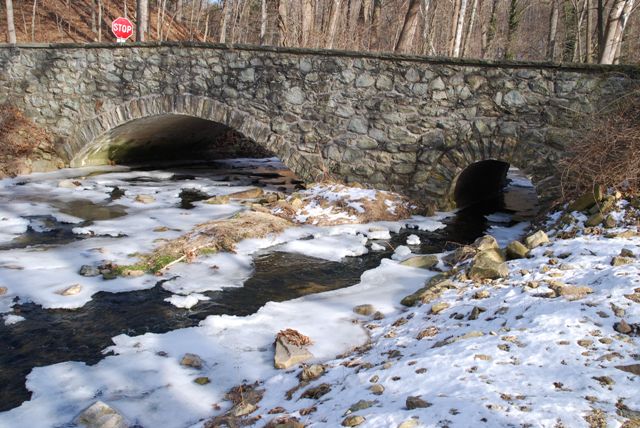
This stone arch bridge has one larger main span and off to one end of the bridge is a second tiny span.
Information and Findings From Pennsylvania's Historic Bridge InventoryDiscussion of Bridge The 2-span, 44'-long stone arch bridge built 1915 has dressed voussoirs, fieldstone spandrel walls, and parapets with some sections of replacement concrete coping. It is supported on stone abutments and pier. The intrados is pargetted and the bridge has several generations of repointing, some with inappropriately thick mortar joints. It is an example of a bridge type that is common from the first two decades of the 20th century in Chester County. The county-built traditional stone arch bridges were favored by the county engineer, and at least 19 similar bridges from 1908 to 1919 have been identified. Stone arch bridges have been in use in Pennsylvania since the late 17th century, and over 350 examples have been identified statewide, with more than two-thirds dating to before 1900. Early 20th century examples in Chester County are considered individually significant in the local context only when they are complete and large or particularly well detailed. This example is not historically or technologically distinguished within its population or by its setting and context. Discussion of Surrounding Area The bridge carries a 2 lane road over a stream in a wooded setting with a scattered mix of 19th- to late-20th-century residences. West of the bridge is an abandoned rail line that has been converted to a hiking trail. Approximately 300' east of the bridge is a row of mid-20thcentury residences. Approximately 200' to the south is an early 19th century vernacular stone residence. Approximately 1/4 mile to the north begins an area of late-20th-century subdivisions. The bridge's immediate setting does not have historic district potential. The Dowlin Forge Site, the ruins of a 18th and early 19th century forge, are located on the road more than .5 mile to the south. Bridge Considered Historic By Survey: No Information and Findings From Pennsylvania's Stone Arch Bridge Management PlanDiscussion of Bridge This bridge is a good candidate for long-term preservation. It ranks in the highest third of all stone bridges under study in this plan. It has a moderate condition code, a result of concern about cracks and loose stones. No scour was noted during the last inspection. It has a high transportation code, a result of low traffic volumes and good sight distance at its approaches. The bridge stands in an area of low development potential, where it can be expected to carry its traffic for some time into the future. Its waterway is adequate. The cost to rehabilitate this bridge would be relatively inexpensive, as its historic fabric is largely intact. Although not listed in or eligible for listing in the National Register of Historic Places individually or as part of a historic district, the bridge is part of a greenway and is locally significant. The bridge has public support (three letters and one meeting at which this bridge was a focus). Ratings The Uwchlan, Dowlin Forge Road is owned by Uwchlan
Township and is ranked 25th. Recommendation: A strong candidate for long-term preservation. |
![]()
![]()
![]()
Coordinates (Latitude, Longitude):
Search For Additional Bridge Listings:
Bridgehunter.com: View listed bridges within 0.5 miles (0.8 kilometers) of this bridge.
Bridgehunter.com: View listed bridges within 10 miles (16 kilometers) of this bridge.
Additional Maps:
Google Streetview (If Available)
GeoHack (Additional Links and Coordinates)
Apple Maps (Via DuckDuckGo Search)
Apple Maps (Apple devices only)
Android: Open Location In Your Map or GPS App
Flickr Gallery (Find Nearby Photos)
Wikimedia Commons (Find Nearby Photos)
Directions Via Sygic For Android
Directions Via Sygic For iOS and Android Dolphin Browser
USGS National Map (United States Only)
Historical USGS Topo Maps (United States Only)
Historic Aerials (United States Only)
CalTopo Maps (United States Only)

© Copyright 2003-2024, HistoricBridges.org. All Rights Reserved. Disclaimer: HistoricBridges.org is a volunteer group of private citizens. HistoricBridges.org is NOT a government agency, does not represent or work with any governmental agencies, nor is it in any way associated with any government agency or any non-profit organization. While we strive for accuracy in our factual content, HistoricBridges.org offers no guarantee of accuracy. Information is provided "as is" without warranty of any kind, either expressed or implied. Information could include technical inaccuracies or errors of omission. Opinions and commentary are the opinions of the respective HistoricBridges.org member who made them and do not necessarily represent the views of anyone else, including any outside photographers whose images may appear on the page in which the commentary appears. HistoricBridges.org does not bear any responsibility for any consequences resulting from the use of this or any other HistoricBridges.org information. Owners and users of bridges have the responsibility of correctly following all applicable laws, rules, and regulations, regardless of any HistoricBridges.org information.
![]()