

View Information About HSR Ratings
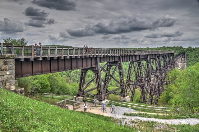
Although the center-section of this otherwise preserved monumental high level railroad bridge was destroyed in a 2003 tornado, the bridge remains a major regional attraction. The current bridge replaced a very delicate Phoenix column deck truss bridge (built 1882) that recieved a lot of engineering attention when it was built due to its length and height: the bridge was the tallest and longest railroad bridge in the world when completed until the Garabit Viaduct in France was completed in 1884. Even the current bridge, when it replaced the Phoenix bridge, was still an engineering achievement and its construction also was covered in engineering periodicals of the time.
The bridge closed to freight trains in 1959 and shortly after was reopened for pedestrian use and use by a tourist railroad, and a state park was created around it. The center section of the bridge collapsed in 2003 when it was hit by an F1 tornado. At the time, a rehab of the bridge was in process, including new anchor bolts added to secure the bents. The spans of the bridge that collapsed had not yet been repaired. It is believed the repaired sections survived the tornado because those repairs had been completed in those spans. The state responded to this disaster in the best way possible. Rather than demolish the remainder of the bridge, the surviving sections were converted into a scenic lookout, so even though you cannot walk all the way across the bridge, you can still appreciate the spans that remain and still offer a spectacular view. Another nice thing that was done is that the collapsed sections were left in place, making this bridge a unique place to observe what a massive bridge collapse looks like. It would appear that the collapsed sections are kept clear of vegetation and growth as the 2021 field visit revealed that the collapsed sections remained visible with no obstruction. While the collapse was unfortunate, the way in which the park moved forward after the collapse kept this bridge and park as a unique destination that remains a very popular attraction today.
Note: The 21 span count given on this page references spans between bents. Some engineers count the girders over the bents as spans as well (41 spans total in that case). The highest elevation of the bridge above the valley is 301 feet.

Above: Historical photo showing previous bridge at location.

Above: Historical photo showing bridge construction. Old bridge to left, current bridge to right.

Above: HAER photo showing current bridge before collapse.
![]()
![]()
![]()
Coordinates (Latitude, Longitude):
Search For Additional Bridge Listings:
Bridgehunter.com: View listed bridges within 0.5 miles (0.8 kilometers) of this bridge.
Bridgehunter.com: View listed bridges within 10 miles (16 kilometers) of this bridge.
Additional Maps:
Google Streetview (If Available)
GeoHack (Additional Links and Coordinates)
Apple Maps (Via DuckDuckGo Search)
Apple Maps (Apple devices only)
Android: Open Location In Your Map or GPS App
Flickr Gallery (Find Nearby Photos)
Wikimedia Commons (Find Nearby Photos)
Directions Via Sygic For Android
Directions Via Sygic For iOS and Android Dolphin Browser
USGS National Map (United States Only)
Historical USGS Topo Maps (United States Only)
Historic Aerials (United States Only)
CalTopo Maps (United States Only)

© Copyright 2003-2024, HistoricBridges.org. All Rights Reserved. Disclaimer: HistoricBridges.org is a volunteer group of private citizens. HistoricBridges.org is NOT a government agency, does not represent or work with any governmental agencies, nor is it in any way associated with any government agency or any non-profit organization. While we strive for accuracy in our factual content, HistoricBridges.org offers no guarantee of accuracy. Information is provided "as is" without warranty of any kind, either expressed or implied. Information could include technical inaccuracies or errors of omission. Opinions and commentary are the opinions of the respective HistoricBridges.org member who made them and do not necessarily represent the views of anyone else, including any outside photographers whose images may appear on the page in which the commentary appears. HistoricBridges.org does not bear any responsibility for any consequences resulting from the use of this or any other HistoricBridges.org information. Owners and users of bridges have the responsibility of correctly following all applicable laws, rules, and regulations, regardless of any HistoricBridges.org information.
![]()