

View Information About HSR Ratings
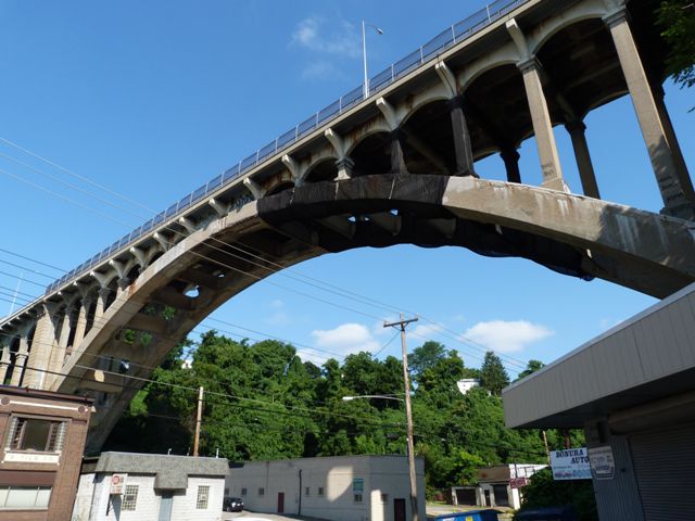
This bridge was the third longest concrete arch bridge span in the world when completed, the longest span in the United States, and the largest in overall size in the world when taking into account width and height. As such it represents a significant engineering achievement. Although the bridge has been altered by the loss of original lighting and railing, the overall bridge retains integrity of design. The bridge is deteriorated, and rather than address issues such as spalling through a rehabilitation project, the city has instead spent money to install an unsightly net around portions of the bridge to catch falling concrete. The net, colored black, is plainly visible. It drastically reduces the aesthetic value of the bridge. It also tends to convey the method that the bridge is unsafe to the many people who are not experienced in bridge construction and inspection. It is hoped that this bridge will eventually be fully rehabilitated so this landmark bridge can continue to offer decades of reliable service.
John Ashley Ferguson apparently played a role in the design of the bridge. Also involved with the design of this bridge was Norman. S. Sprague, Superintendent, Bureau of Construction and T. J. Wilkerson, Division Engineer.

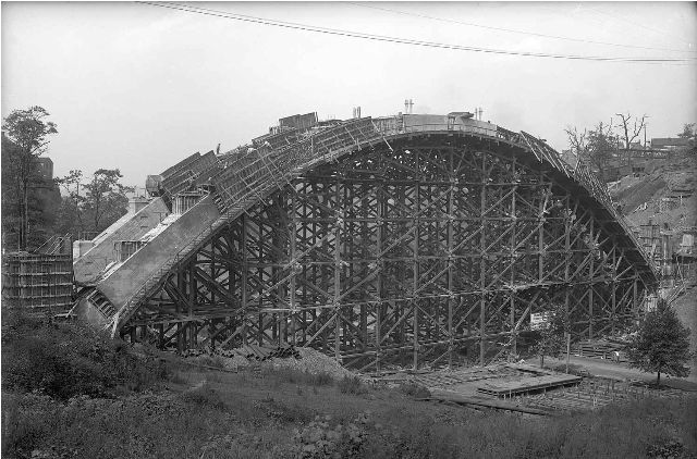
Above: A historical photo shows the massive arch centering falsework used to erect the bridge. More historical photos are available in the photo gallery.
Information and Findings From Pennsylvania's Historic Bridge InventoryDiscussion of Bridge The 8-span, 548'-long bridge built in 1912 consists of a ribbed, 300'-long, reinforced concrete, open spandrel arch main span and seven 30'-long reinforced concrete deck girder approach spans. The arch has plain spandrel columns with capitals. The main span's deck and floorbeams were replaced from the spandrel columns up in 1981. Original concrete balustrades were replaced by tubular metal railings. The deck girder spans have haunched fasciae girders to mirror the spacing of the open spandrels of the main span. The bridge is the earliest of 13 extant open spandrel arch bridges from 1912 to 1950 in Allegheny County. It was built as part of a bridge-building program initiated in 1908 by the City of Pittsburgh. The city public works department embraced the City Beautiful Movement and adopted reinforced concrete bridge arches with Classical-style architectural details. Open spandrel arch bridges, which had been introduced in the state about 1905, were particularly well suited to long-span crossings where an aesthetic bridge was desired. This example was considered the longest reinforced concrete arch in the nation when built, although it was very shortly surpassed. Pittsburgh's builders continued to push the technology to its limits, eventually building the longest example in the world, the Westinghouse Bridge (1931). The bridge is historically and technologically distinguished as an early example in the city and region. Discussion of Surrounding Area The bridge carries a 2 lane street and sidewalks over a 4 lane state highway between Pittsburgh's Homewood and East Liberty neighborhoods. At the east end is an undistinguished neighborhood of vernacular, early 20th century residences. At the west end is a similarly undistinguished mid-20th century commercial district of boarded up storefronts. The area does not have historic district potential. Bridge Considered Historic By Survey: Yes |
![]()
![]()
![]()
![]()
![]()
Coordinates (Latitude, Longitude):
Search For Additional Bridge Listings:
Bridgehunter.com: View listed bridges within 0.5 miles (0.8 kilometers) of this bridge.
Bridgehunter.com: View listed bridges within 10 miles (16 kilometers) of this bridge.
Additional Maps:
Google Streetview (If Available)
GeoHack (Additional Links and Coordinates)
Apple Maps (Via DuckDuckGo Search)
Apple Maps (Apple devices only)
Android: Open Location In Your Map or GPS App
Flickr Gallery (Find Nearby Photos)
Wikimedia Commons (Find Nearby Photos)
Directions Via Sygic For Android
Directions Via Sygic For iOS and Android Dolphin Browser
USGS National Map (United States Only)
Historical USGS Topo Maps (United States Only)
Historic Aerials (United States Only)
CalTopo Maps (United States Only)

© Copyright 2003-2024, HistoricBridges.org. All Rights Reserved. Disclaimer: HistoricBridges.org is a volunteer group of private citizens. HistoricBridges.org is NOT a government agency, does not represent or work with any governmental agencies, nor is it in any way associated with any government agency or any non-profit organization. While we strive for accuracy in our factual content, HistoricBridges.org offers no guarantee of accuracy. Information is provided "as is" without warranty of any kind, either expressed or implied. Information could include technical inaccuracies or errors of omission. Opinions and commentary are the opinions of the respective HistoricBridges.org member who made them and do not necessarily represent the views of anyone else, including any outside photographers whose images may appear on the page in which the commentary appears. HistoricBridges.org does not bear any responsibility for any consequences resulting from the use of this or any other HistoricBridges.org information. Owners and users of bridges have the responsibility of correctly following all applicable laws, rules, and regulations, regardless of any HistoricBridges.org information.
![]()