

View Information About HSR Ratings
This relatively early rivet-connected through highway truss bridge is also noted for its handsome railing. The
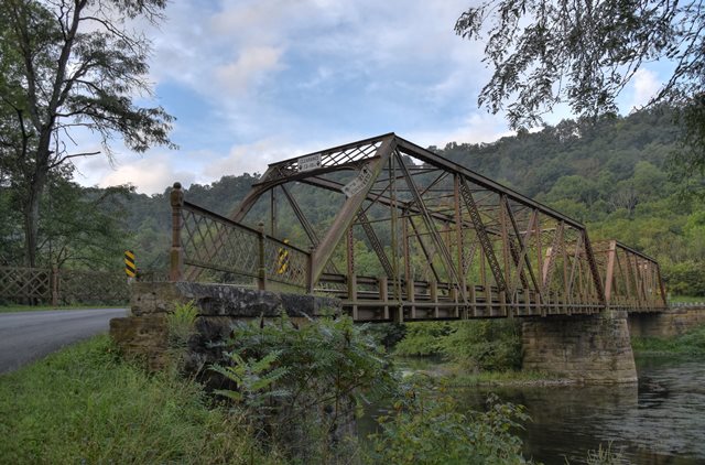
Information and Findings From Pennsylvania's Historic Bridge InventoryDiscussion of Bridge The 2 span, 262'-long, pin-connected Pratt thru truss bridge built in 1905 is supported on an ashlar pier and abutments with flared wingwalls. The trusses are traditionally composed with the upper chords and end posts being built up box sections, the verticals and diagonals being channels or angles with lacing, and the lower chords and end panel diagonals being eye bars. Rolled floorbeams and stringers carry an open steel grid deck place in 1960. the original lattice railings have been replaced by W-beam guiderails placed inside the trusses. Sections of the lattice railings remain atop the eastern wingwalls only. The bridge has no innovative or distinctive details, and it reflects the standarization that came to dominate the pin-connected Pratt truss type/design after the mid 1890s. It is not historically or technologically significant. It is located in a region with over 120 metal truss bridges dating from ca. 1880 through the 1940s. Discussion of Surrounding Area The bridge carries a 2 lane road over a stream in a rural setting with a modern campground at the SE quadrant. Beyond the NW quadrant is a highly altered vernacular ca. 1900 frame house. The setting does not have the cohesiveness or integrity of a historic district. Bridge Considered Historic By Survey: Yes (Updated Finding Below)
•Early use of rolled metal truss members |
![]()
![]()
![]()
Coordinates (Latitude, Longitude):
Search For Additional Bridge Listings:
Bridgehunter.com: View listed bridges within 0.5 miles (0.8 kilometers) of this bridge.
Bridgehunter.com: View listed bridges within 10 miles (16 kilometers) of this bridge.
Additional Maps:
Google Streetview (If Available)
GeoHack (Additional Links and Coordinates)
Apple Maps (Via DuckDuckGo Search)
Apple Maps (Apple devices only)
Android: Open Location In Your Map or GPS App
Flickr Gallery (Find Nearby Photos)
Wikimedia Commons (Find Nearby Photos)
Directions Via Sygic For Android
Directions Via Sygic For iOS and Android Dolphin Browser
USGS National Map (United States Only)
Historical USGS Topo Maps (United States Only)
Historic Aerials (United States Only)
CalTopo Maps (United States Only)

© Copyright 2003-2024, HistoricBridges.org. All Rights Reserved. Disclaimer: HistoricBridges.org is a volunteer group of private citizens. HistoricBridges.org is NOT a government agency, does not represent or work with any governmental agencies, nor is it in any way associated with any government agency or any non-profit organization. While we strive for accuracy in our factual content, HistoricBridges.org offers no guarantee of accuracy. Information is provided "as is" without warranty of any kind, either expressed or implied. Information could include technical inaccuracies or errors of omission. Opinions and commentary are the opinions of the respective HistoricBridges.org member who made them and do not necessarily represent the views of anyone else, including any outside photographers whose images may appear on the page in which the commentary appears. HistoricBridges.org does not bear any responsibility for any consequences resulting from the use of this or any other HistoricBridges.org information. Owners and users of bridges have the responsibility of correctly following all applicable laws, rules, and regulations, regardless of any HistoricBridges.org information.
![]()