

View Information About HSR Ratings
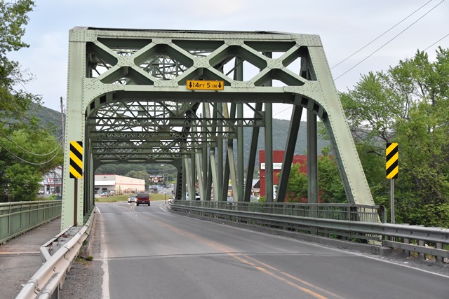
This state standard through truss bridge continues to carry traffic on a busy two lane highway. The bridge is noted for retaining original railings, although single Armco guardrails have also been added.
Information and Findings From Pennsylvania's Historic Bridge InventoryDiscussion of Bridge The 1933, single span, 205'-long, 8 panel, rivet-connected, Parker thru truss bridge is supported on concrete abutments with wingwalls. The polygonal upper chords are built up box sections, the lower chords consist of channels with battens, and the verticals and diagonals are rolled sections. The bridge is an example of a state highway department standard design rivet-connected truss bridge with rolled section verticals and diagonals. The design was used with great frequency beginning in the mid 1920s. The bridge has no innovative or distinctive details. Approximately 75 riveted Parker truss bridges built between 1925 and 1957 remain statewide. Neither the bridge nor its setting is historically or technologically significant. Discussion of Surrounding Area The bridge carries a 2 lane road with a sidewalk over a stream in a mixed-use area of undistinguished 20th century vernacular houses and late 20th century commercial strip development, although the quadrants are wooded. The setting does not have historic district potential. Bridge Considered Historic By Survey: No |
![]()
![]()
![]()
Coordinates (Latitude, Longitude):
Search For Additional Bridge Listings:
Bridgehunter.com: View listed bridges within 0.5 miles (0.8 kilometers) of this bridge.
Bridgehunter.com: View listed bridges within 10 miles (16 kilometers) of this bridge.
Additional Maps:
Google Streetview (If Available)
GeoHack (Additional Links and Coordinates)
Apple Maps (Via DuckDuckGo Search)
Apple Maps (Apple devices only)
Android: Open Location In Your Map or GPS App
Flickr Gallery (Find Nearby Photos)
Wikimedia Commons (Find Nearby Photos)
Directions Via Sygic For Android
Directions Via Sygic For iOS and Android Dolphin Browser
USGS National Map (United States Only)
Historical USGS Topo Maps (United States Only)
Historic Aerials (United States Only)
CalTopo Maps (United States Only)

© Copyright 2003-2024, HistoricBridges.org. All Rights Reserved. Disclaimer: HistoricBridges.org is a volunteer group of private citizens. HistoricBridges.org is NOT a government agency, does not represent or work with any governmental agencies, nor is it in any way associated with any government agency or any non-profit organization. While we strive for accuracy in our factual content, HistoricBridges.org offers no guarantee of accuracy. Information is provided "as is" without warranty of any kind, either expressed or implied. Information could include technical inaccuracies or errors of omission. Opinions and commentary are the opinions of the respective HistoricBridges.org member who made them and do not necessarily represent the views of anyone else, including any outside photographers whose images may appear on the page in which the commentary appears. HistoricBridges.org does not bear any responsibility for any consequences resulting from the use of this or any other HistoricBridges.org information. Owners and users of bridges have the responsibility of correctly following all applicable laws, rules, and regulations, regardless of any HistoricBridges.org information.
![]()