

View Information About HSR Ratings
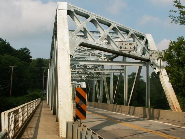
This bridge is a heavily skewed state standard plan truss bridge. V-lacing is only present on the overhead bracing, and lattice is only under the top chord, while vertical and diagonal members are rolled i-beams. Pennsylvania had a wide variety of "standard plan" metal truss bridges, and this design appears to be the last of the through truss designs. The later design is visually distinguished by a less complex appearance, but with many examples that have heavy, and easily noticeable skews and impressive portal bracing with an imposing appearance. These visually pleasing bridges are an asset to Pennsylvania's landscape even if PennDOT does not see them as such.
Information and Findings From Pennsylvania's Historic Bridge InventoryDiscussion of Bridge The skewed, two-span, 310'-long, riveted Pratt thru truss bridge built in 1932 is supported on an ashlar substructure with concrete caps. The upper chords and end posts are built up box sections, and the diagonal members are rolled section. Lower chords are toe in channels with stay plates. The cantilevered sidewalk is finished with a metal lattice railing. Safety shape barriers were placed inside the truss lines in 1984. The bridge has no distinctive or innovative details, and neither it nor its setting are historically or technologically significant. Discussion of Surrounding Area The bridge carries a two-lane road and a sidewalk over a stream in a sparsely developed, rural area with post-World War II houses on both sides of the bridge. Bridge Considered Historic By Survey: No |
![]()
![]()
![]()
This historic bridge has been demolished. This map is shown for reference purposes only.
Coordinates (Latitude, Longitude):
Search For Additional Bridge Listings:
Bridgehunter.com: View listed bridges within 0.5 miles (0.8 kilometers) of this bridge.
Bridgehunter.com: View listed bridges within 10 miles (16 kilometers) of this bridge.
Additional Maps:
Google Streetview (If Available)
GeoHack (Additional Links and Coordinates)
Apple Maps (Via DuckDuckGo Search)
Apple Maps (Apple devices only)
Android: Open Location In Your Map or GPS App
Flickr Gallery (Find Nearby Photos)
Wikimedia Commons (Find Nearby Photos)
Directions Via Sygic For Android
Directions Via Sygic For iOS and Android Dolphin Browser
USGS National Map (United States Only)
Historical USGS Topo Maps (United States Only)
Historic Aerials (United States Only)
CalTopo Maps (United States Only)

© Copyright 2003-2024, HistoricBridges.org. All Rights Reserved. Disclaimer: HistoricBridges.org is a volunteer group of private citizens. HistoricBridges.org is NOT a government agency, does not represent or work with any governmental agencies, nor is it in any way associated with any government agency or any non-profit organization. While we strive for accuracy in our factual content, HistoricBridges.org offers no guarantee of accuracy. Information is provided "as is" without warranty of any kind, either expressed or implied. Information could include technical inaccuracies or errors of omission. Opinions and commentary are the opinions of the respective HistoricBridges.org member who made them and do not necessarily represent the views of anyone else, including any outside photographers whose images may appear on the page in which the commentary appears. HistoricBridges.org does not bear any responsibility for any consequences resulting from the use of this or any other HistoricBridges.org information. Owners and users of bridges have the responsibility of correctly following all applicable laws, rules, and regulations, regardless of any HistoricBridges.org information.
![]()