

View Information About HSR Ratings
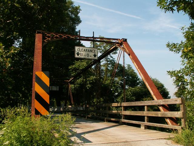
This bridge appears to have been built by the locally prolific Penn Bridge Company based on the unusual detail that company often used, which was two pins at the top chord / end post connection, with one pin for the diagonal members, and one for the hip vertical. It is unclear what advantage the company thought using two pins provided.
This bridge is an attractive example of its type. It remains with decent integrity, although some alteration was observed, most notably the loss of some of the original built-up floor beams. A few of the original floorbeams do remain however, and they are impressive shaped beams that should be preserved and not removed as part of any future repair or restoration. This is one of the few historic truss bridges in Pennsylvania that was at least minimally repaired recently, with a 2003 rehabilitation date that apparently included replacement of the deck and railings.
Information and Findings From Pennsylvania's Historic Bridge InventoryDiscussion of Bridge The one-span, 98'-long, pin-connected Pratt thru truss bridge is supported on ashlar abutments with wingwalls. The trusses are traditionally composed, but the upper hip panel point has two pins (one of the floor beam hanger and one for the diagonal) instead of the more common single pin. The designer/fabricator of the bridge is not known, but the bridge dates stylistically to ca. 1885. It may be the work of the Penn Bridge Co. that was located in Beaver Falls and was building bridges in the county by 1878. The bridge is historically and technologically significant based on its date, completeness, and uncommon connection detail. It also has some original built up floorbeams. Discussion of Surrounding Area The bridge carries a single-lane road over Little Beaver Creek in a sparsely developed, rural setting with scattered modern houses. Bridge Considered Historic By Survey: Yes |
![]()
![]()
This historic bridge has been demolished. This map is shown for reference purposes only.
Coordinates (Latitude, Longitude):
Search For Additional Bridge Listings:
Bridgehunter.com: View listed bridges within 0.5 miles (0.8 kilometers) of this bridge.
Bridgehunter.com: View listed bridges within 10 miles (16 kilometers) of this bridge.
Additional Maps:
Google Streetview (If Available)
GeoHack (Additional Links and Coordinates)
Apple Maps (Via DuckDuckGo Search)
Apple Maps (Apple devices only)
Android: Open Location In Your Map or GPS App
Flickr Gallery (Find Nearby Photos)
Wikimedia Commons (Find Nearby Photos)
Directions Via Sygic For Android
Directions Via Sygic For iOS and Android Dolphin Browser
USGS National Map (United States Only)
Historical USGS Topo Maps (United States Only)
Historic Aerials (United States Only)
CalTopo Maps (United States Only)

© Copyright 2003-2024, HistoricBridges.org. All Rights Reserved. Disclaimer: HistoricBridges.org is a volunteer group of private citizens. HistoricBridges.org is NOT a government agency, does not represent or work with any governmental agencies, nor is it in any way associated with any government agency or any non-profit organization. While we strive for accuracy in our factual content, HistoricBridges.org offers no guarantee of accuracy. Information is provided "as is" without warranty of any kind, either expressed or implied. Information could include technical inaccuracies or errors of omission. Opinions and commentary are the opinions of the respective HistoricBridges.org member who made them and do not necessarily represent the views of anyone else, including any outside photographers whose images may appear on the page in which the commentary appears. HistoricBridges.org does not bear any responsibility for any consequences resulting from the use of this or any other HistoricBridges.org information. Owners and users of bridges have the responsibility of correctly following all applicable laws, rules, and regulations, regardless of any HistoricBridges.org information.
![]()