

View Information About HSR Ratings
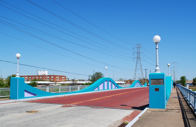
Not only is this an extremely rare example of a concrete curved chord through girder bridge, it is further unique for its continuous design. Only a few states ever built concrete curved chord through girder bridges, sometimes called concrete camelback bridges. Only Michigan and Ohio built them in significant numbers, and a handful of additional states have a few sporadic examples. This is one such sporadic example, as it is not a standard design in Texas and is the only one of its kind in the state. Actually, it is the only known concrete curved chord through girder bridge to feature a continuous design. This bridge type was normally built as simple spans when multiple spans were used. The unusual design also resulted in the deepest girder sections being over the piers, rather than in between as would be the case with simple spans. The main span is 120 feet, making it the longest known span of a concrete through girder, beating the 2nd place span of 100 feet in Michigan which itself is also unique, and 10 feet longer than the next longest known examples, which are Michigan's 90 foot standard concrete camelback spans.
This bridge is tagged with the following special condition(s): Unorganized Photos
![]()
![]()
![]()
Coordinates (Latitude, Longitude):
Search For Additional Bridge Listings:
Bridgehunter.com: View listed bridges within 0.5 miles (0.8 kilometers) of this bridge.
Bridgehunter.com: View listed bridges within 10 miles (16 kilometers) of this bridge.
Additional Maps:
Google Streetview (If Available)
GeoHack (Additional Links and Coordinates)
Apple Maps (Via DuckDuckGo Search)
Apple Maps (Apple devices only)
Android: Open Location In Your Map or GPS App
Flickr Gallery (Find Nearby Photos)
Wikimedia Commons (Find Nearby Photos)
Directions Via Sygic For Android
Directions Via Sygic For iOS and Android Dolphin Browser
USGS National Map (United States Only)
Historical USGS Topo Maps (United States Only)
Historic Aerials (United States Only)
CalTopo Maps (United States Only)

© Copyright 2003-2024, HistoricBridges.org. All Rights Reserved. Disclaimer: HistoricBridges.org is a volunteer group of private citizens. HistoricBridges.org is NOT a government agency, does not represent or work with any governmental agencies, nor is it in any way associated with any government agency or any non-profit organization. While we strive for accuracy in our factual content, HistoricBridges.org offers no guarantee of accuracy. Information is provided "as is" without warranty of any kind, either expressed or implied. Information could include technical inaccuracies or errors of omission. Opinions and commentary are the opinions of the respective HistoricBridges.org member who made them and do not necessarily represent the views of anyone else, including any outside photographers whose images may appear on the page in which the commentary appears. HistoricBridges.org does not bear any responsibility for any consequences resulting from the use of this or any other HistoricBridges.org information. Owners and users of bridges have the responsibility of correctly following all applicable laws, rules, and regulations, regardless of any HistoricBridges.org information.
![]()