

View Information About HSR Ratings
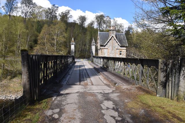
This lattice girder sits next to a notable gate lodge with turret. The exact date of construction is not known. The bridge and lodge are part of the Ardverikie Estate.
Official Heritage Listing Information and FindingsListed At: Category A Discussion: List Entry Number: LB6911 John Rhind, circa 1874-8. Rectangular gate lodge with turret. 2 storeys over raised basement. Projecting round stair turret at NE angle with bellcast conical slate roof. Coursed tooled grey granite, contrasting tooled ashlar dressings. Entrance in NW re-entrant formed by turret under slated canopy supported on elaborately carved wooden brackets on N with segmentally arched bench recess at centre. Plank door with decorative cast-iron hinges. Further entrance in raised basement on E elevation. Tripartite in raised ground floor, and bipartite in 1st floor of W gable (to driveway); 2-pane glazing. Off-set lancets encircle stair turret. Coped wallhead stack; slate roof with projecting eaves. Gate piers; pair tall square tooled grey granite ashlar piers rising from battered plinths; bracketted ashlar cornice with pyramid-finial caps. Pair case and wrought-iron carriage gates. Bridge; plain flat arched bridge supported by rubble end abutments; cast-iron lattice girder balustrade. Statement of Special Interest The lodge seems to have been built some time after the 1873-8 remodelling of the house but, with the bridge, was extant by the turn of the century. The stables and offices detached to the S of the house at NN5090 8725 were built after the construction of the bridge; prior to this horses and carriages were left at Cromra on the N shore of Loch Laggan, opposite Ardverikie, the final part of the journey being by boat. John Rhind died in 1889. References Information courtesy of Mr Chamler and Lady Feilden. |
![]()
![]()
![]()
Coordinates (Latitude, Longitude):
Search For Additional Bridge Listings:
Additional Maps:
Google Streetview (If Available)
GeoHack (Additional Links and Coordinates)
Apple Maps (Via DuckDuckGo Search)
Apple Maps (Apple devices only)
Android: Open Location In Your Map or GPS App
Flickr Gallery (Find Nearby Photos)
Wikimedia Commons (Find Nearby Photos)
Directions Via Sygic For Android
Directions Via Sygic For iOS and Android Dolphin Browser
Ordnance Survey Maps (UK Only)

© Copyright 2003-2024, HistoricBridges.org. All Rights Reserved. Disclaimer: HistoricBridges.org is a volunteer group of private citizens. HistoricBridges.org is NOT a government agency, does not represent or work with any governmental agencies, nor is it in any way associated with any government agency or any non-profit organization. While we strive for accuracy in our factual content, HistoricBridges.org offers no guarantee of accuracy. Information is provided "as is" without warranty of any kind, either expressed or implied. Information could include technical inaccuracies or errors of omission. Opinions and commentary are the opinions of the respective HistoricBridges.org member who made them and do not necessarily represent the views of anyone else, including any outside photographers whose images may appear on the page in which the commentary appears. HistoricBridges.org does not bear any responsibility for any consequences resulting from the use of this or any other HistoricBridges.org information. Owners and users of bridges have the responsibility of correctly following all applicable laws, rules, and regulations, regardless of any HistoricBridges.org information.
![]()