HistoricBridges.org Menu: HistoricBridges.org Menu:


We Recommend:
Bach Steel - Experts at historic truss bridge restoration.

HistoricBridges.org: Bridge Browser

Royal Albert Bridge

Royal Albert Bridge

Primary Photographer(s): Nathan Holth

Bridge Documented: May 10, 2018

View Photos
and Videos
View Maps
and Links

Facility Carried / Feature Intersected
Railroad (Network Rail) Over River Tamar
Location
Saltash and Plymouth: South West, England: United Kingdom
Structure Type
Metal 12 Panel Multiple-Type-Connected Lenticular Through Truss, Fixed and Approach Spans: Metal Deck Girder, Fixed
Construction Date and Builder / Engineer
1859 By Builder/Contractor: Charles John Mare and Hudson and Male and Engineer/Design: Isambard Kingdom Brunel
Rehabilitation Date
2014
Main Span Length
455.0 Feet (138.7 Meters)
Structure Length
2,187.5 Feet (666.8 Meters)
Roadway Width
16.8 Feet (5.12 Meters)
Spans
2 Main Span(s) and 17 Approach Span(s)
Inventory Number
Not Applicable

Historic Significance Rating (HSR)
View Information About HSR Ratings

Bridge Documentation

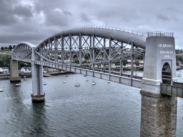
The Royal Albert Bridge is one of the most impressive bridges in the UK and indeed the world. Built in 1859, this bridge's 455 truss spans represented an unimaginable span length for metal truss bridges at the time. Even more impressive, these spans were assembled along the nearby shore, floated into position and slowly lifted into their place high above the river (100 feet of navigation clearance) as the end piers were constructed. Even today in bridge construction, moving a pre-fabricated span of 455 feet would be worthy of a news article. Imagine what an impressive feat this would have been in 1859.

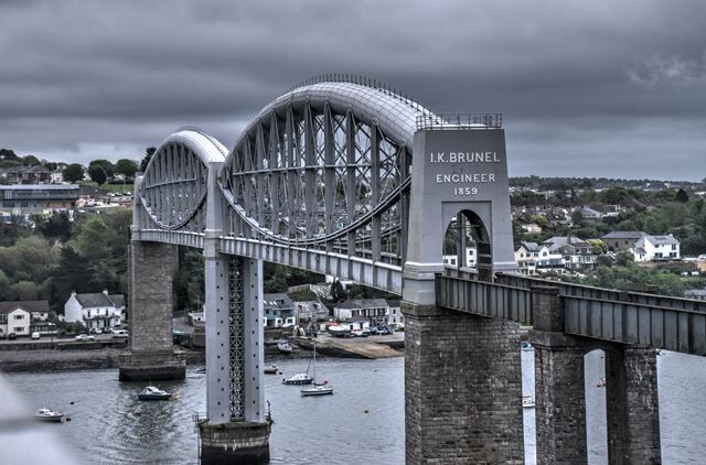
This unique bridge was one of the crowning achievements of famous engineer Isambard Kingdom Brunel. He died shortly after the bridge was completed, and the bridge had his name added to the portals in honor of him. Brunel's design here resulted in one of the first lenticular truss bridges in the world, using a unique massive tubular top chord. 

This bridge remains in good condition today and continues to serve rail traffic. It was rehabilitated in 2010-2014. The historic integrity of the two main spans is good, although some alterations have taken place care has been made to preserve and not alter the original design details created by Brunel. An exception is the approach spans of the bridge. The original Brunel designed plate girder approach spans (which were similar to the deck-level girders that remain on the main truss spans) were replaced ca. 1905 with standard looking riveted plate girders.

Above: This historical image shows the assembly of one of the truss spans along the river.

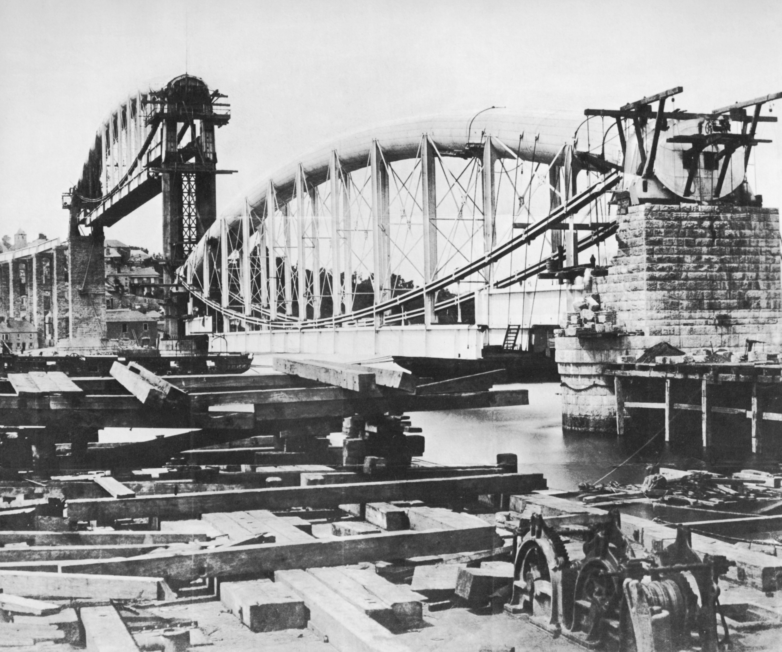
Above: This photo shows the second truss span being slowly lifted into place as the far pier was constructed.

Above: This historical photo shows the original approach plate girder spans.

Official Heritage Listing Information and Findings

Listed At: Grade I

Discussion:

List Entry Number: 1159292

Royal Albert Bridge and seventeen approach spans (formerly listed as Royal Albert Bridge (the part within the Borough of Saltash) Railway bridge over River Tamar by Isambard Kingdom Brunel for the Cornwall Railway while it was leased to the Great Western Railway. Begun 1848, restarted 1854 and completed 1859, I K Brunel, the engineer, being first across, although on the verge of death. Granite built piers, the land piers paired, the outer water piers solid on oval plinths, the central pier and group of four octagonal piers linked by trelliswork. The two main spans are 135 metres each and are carried by an ingenious form of suspension (by cast iron segmental tubes) - the only one of its kind surviving to carry a railway. In engineering terms, it is known as a bowstring tubular plate girder bridge, a combination of suspension and arches structure, the two tubular arches, with outward thrust onto the abutments, counteracting the inward drag of the chains. The portals on the outer river piers are in pylon style, ashlar faced, with tall elliptical arches in square recesses. The Cornish side has raised lettering above the arch "I K Brunel Engineer 1859". There are, in all, seventeen approach spans (on both sides), the Cornish side ones towering above what remains of the inner town on the quay, curve south-west towards the station. The bridge is 51 metres above high water mark to the top of the tubes (the Admiralty specified 30 metres mast clearance). It cost under £225,000. At the time, and now, it was regarded as a triumph of engineering.

Divider

Photo Galleries and Videos: Royal Albert Bridge


View Photo Gallery

Structure Overview

Original / Full Size Photos
A collection of overview photos that show the bridge as a whole and general areas of the bridge. This gallery offers photos in the highest available resolution and file size in a touch-friendly popup viewer.
Alternatively, Browse Without Using Viewer

Divider

View Photo Gallery

Structure Details

Original / Full Size Photos
A collection of detail photos that document the parts, construction, and condition of the bridge. This gallery offers photos in the highest available resolution and file size in a touch-friendly popup viewer.
Alternatively, Browse Without Using Viewer

Divider

View Photo Gallery

Structure Overview

Mobile Optimized Photos
A collection of overview photos that show the bridge as a whole and general areas of the bridge. This gallery features data-friendly, fast-loading photos in a touch-friendly popup viewer.
Alternatively, Browse Without Using Viewer

Divider

View Photo Gallery

Structure Details

Mobile Optimized Photos
A collection of detail photos that document the parts, construction, and condition of the bridge. This gallery features data-friendly, fast-loading photos in a touch-friendly popup viewer.
Alternatively, Browse Without Using Viewer

Divider

Maps and Links: Royal Albert Bridge

Coordinates (Latitude, Longitude):

Search For Additional Bridge Listings:

HistoricBridges.org Bridge Browser: View listed bridges within 0.5 miles (0.8 kilometers) of this bridge.

HistoricBridges.org Bridge Browser: View listed bridges within 10 miles (16 kilometers) of this bridge.

Additional Maps:

Google Maps

Google Streetview (If Available)

Bing Maps

OpenStreetMap

GeoHack (Additional Links and Coordinates)

Apple Maps (Via DuckDuckGo Search)

Apple Maps (Apple devices only)

MapQuest

HERE We Go Maps

ACME Mapper

Waze Map

Android: Open Location In Your Map or GPS App

Flickr Gallery (Find Nearby Photos)

Wikimedia Commons (Find Nearby Photos)

Directions Via Sygic For Android

Directions Via Sygic For iOS and Android Dolphin Browser

Ordnance Survey Maps (UK Only)


Divider
 
Home Top

Divider

About - Contact

© Copyright 2003-2024, HistoricBridges.org. All Rights Reserved. Disclaimer: HistoricBridges.org is a volunteer group of private citizens. HistoricBridges.org is NOT a government agency, does not represent or work with any governmental agencies, nor is it in any way associated with any government agency or any non-profit organization. While we strive for accuracy in our factual content, HistoricBridges.org offers no guarantee of accuracy. Information is provided "as is" without warranty of any kind, either expressed or implied. Information could include technical inaccuracies or errors of omission. Opinions and commentary are the opinions of the respective HistoricBridges.org member who made them and do not necessarily represent the views of anyone else, including any outside photographers whose images may appear on the page in which the commentary appears. HistoricBridges.org does not bear any responsibility for any consequences resulting from the use of this or any other HistoricBridges.org information. Owners and users of bridges have the responsibility of correctly following all applicable laws, rules, and regulations, regardless of any HistoricBridges.org information.

Admin Login

Divider